Normal view

There are new articles available, click to refresh the page.
Before yesterdayMain stream

How 2 US, European Satellites Are Studying Hurricanes During El Niño

9 September 2026 at 12:00

5 min read

Preparations for Next Moonwalk Simulations Underway (and Underwater)

Category 5 Hurricane Melissa, one of the most powerful storms to strike the Caribbean in recent history, is pictured about 50 miles south of Jamaica in this photograph from the International Space Station as it orbited 262 miles above the Yucatan Peninsula.
Hurricane Melissa is seen 50 miles south of Jamaica in this photograph taken from the International Space Station on Oct. 28, 2025.
NASA

Last November, NASA and its European partners launched the Sentinel-6B satellite to improve hurricane forecasts, help protect infrastructure, and benefit commercial industries, including shipping. The satellite now is flying 30 seconds behind its predecessor, Sentinel-6 Michael Freilich. Both satellites are providing precise sea level height measurements during what oceanographers expect to be a historic El Niño, a naturally occurring oceanic phenomenon in which warmer-than-usual Pacific waters shift global weather patterns.

The two satellites make up the Copernicus Sentinel-6/Jason-CS (Continuity of Service) mission, the latest in a series of ocean-observing radar altimetry missions that have been monitoring Earth’s changing seas continuously since the early 1990s.

The data each satellite is collecting will not only allow scientists to better understand this year’s El Niño but will also help them create more accurate hurricane predictions.

“This El Niño was a late-bloomer,” said Josh Willis, Sentinel-6B’s project scientist at NASA’s Jet Propulsion Laboratory in Southern California. “It didn’t kick off until the middle of the year and is just now reaching a strength similar to what we’ve seen in the satellite record during significant El Niños in 1997 and 2015. We expect it to be big, and it’s already having big impacts.”

El Niños generally scramble weather patterns tied to rainfall and storms, including hurricanes. They also redistribute heat in the ocean, which affects sea level. Normally, Earth’s warmest ocean waters sit along the equator in the western Pacific. During El Niño, weakened winds, which usually blow westward along the equator, result in heat spreading east toward South America. The change in ocean heat shifts hurricane activity from the Atlantic to the Pacific Ocean.

Predicting hurricane strength

On July 15, Sentinel-6B began delivering low-latency data to scientists that could be used for weather predictions. That data will take some time to work its way into the research models on which meteorologists and climate scientists rely, but when it does, those improved models could save lives.

Data from Sentinel-6 satellite missions feeds into hurricane tracking algorithms used by federal and state agencies. Those predictions can activate disaster response efforts, mobilizing resources ranging from sandbag placement to National Guard activation. They also can lead to evacuation orders that require quick but well-informed decisions about logistics at a local level. More severe events may require engaging larger organizations, such as the Federal Emergency Management Agency.

A tropical storm can take a week or more to become a hurricane and make its way to a coastline, but a hurricane can rapidly intensify in the 48 hours prior to landfall, leaving planners little time to prepare.

“Hurricanes have been known to speed up quickly at the last moment, so the window in which to decide what to do is short,” said Deirdre Byrne, an oceanographer and altimetry expert with the National Oceanic and Atmospheric Administration (NOAA). “The goal is to forecast how much and how rapidly intensification will happen so that officials can make the right calls.”

Byrne oversees one of the country’s most crucial hurricane forecasting algorithms, NOAA’s Satellite Ocean Heat Content Suite, which has been operating since 2012.

Each Sentinel-6 satellite measures ocean height, as well as the size of waves and marine wind speed, using a radar altimeter, which bounces thousands of radar pulses a second off the crests and troughs of waves. Ocean height varies from place to place and provides insight into the ocean’s heat content, since warm water expands. That, in turn, helps forecast how fast hurricanes will grow.

The satellites each carry a second instrument, called the Global Navigation Satellite System – Radio Occultation (GNSS-RO), which measures atmospheric properties, such as humidity, pressure, and temperature.

Among the measurements Sentinel-6 is gathering, Byrne is most anticipating the ocean height data, which she plans to begin incorporating into the current Satellite Ocean Heat Content Suite algorithm by the end of the year.

“In terms of data quality, the Sentinel-6 missions are unparalleled,” Byrne said.

Together, the missions are also extending a precise dataset deep into its fourth decade. This record of sea level observations traces back to the TOPEX/Poseidon mission, which launched in 1992, and continues through to the present day with Sentinel-6 Michael Freilich. Sentinel-6B will take over for its predecessor as the reference satellite for global sea level measurements later this year.

“The key is consistency, measuring the same way, every time,” said Severine Fournier, Sentinel-6B deputy project scientist, JPL. “That’s what lets us predict hurricanes, and, in turn, protect coastal communities and infrastructure.”

More about Sentinel-6B

Sentinel-6 Michael Freilich, named after a former director of NASA’s Earth Science Division, is one of two satellites that compose the Copernicus Sentinel-6/Jason-CS mission.

Sentinel-6/Jason-CS, a part of the European Union’s Earth observation program called Copernicus, was jointly developed by ESA (European Space Agency), EUMETSAT (European Organisation for the Exploitation of Meteorological Satellites), NASA, and NOAA, with funding support from the European Commission and technical support on performance from the French space agency CNES (Centre National d’Études Spatiales). Spacecraft monitoring and control, as well as the processing of all the altimeter science data, is carried out by EUMETSAT on behalf of the European Union’s Copernicus Programme, with the support of all partner agencies.

NASA JPL, a division of Caltech in Pasadena, contributed three science instruments for each Sentinel-6 satellite: the Advanced Microwave Radiometer, the GNSS-RO, and the Laser Retroreflector Array. NASA also contributed launch services, ground systems supporting operation of the agency’s science instruments, the science data processors for two of these instruments, and support for the United States members of the international Ocean Surface Topography Science Team.

For more about Sentinel-6B, visit:

https://science.nasa.gov/mission/sentinel-6B

-end-

Media Contacts

Andrew Good / Andrew Wang
Jet Propulsion Laboratory, Pasadena, Calif.
818-393-2433 / 626-379-6874
andrew.c.good@jpl.nasa.gov / andrew.wang@jpl.nasa.gov

2026-060

Without new landers or rovers, it's helicopters or bust for NASA's Mars program

1 September 2026 at 07:00

For the first time in more than 30 years, NASA has no firm plans to send any new landers or rovers to Mars. Instead, the agency's near-term focus at the red planet is on aerial drones, a pioneering mode of exploration that didn't seem realistic until a few years ago.

The first real use of drones for science at Mars will come with the SkyFall mission, a fleet of three helicopters set for launch as soon as late 2028. SkyFall's helicopters will ride to the red planet with NASA's Space Reactor-1 "Freedom" mission, which has the primary objective of demonstrating nuclear electric propulsion in deep space.

The launch schedule is aggressive for SR-1 Freedom and SkyFall, projects that didn't even exist in NASA's portfolio six months ago. NASA's plan for the SR-1 Freedom mission, estimated to cost $2.1 billion, calls for repurposing the core module of the canceled Gateway lunar space station into a testbed for nuclear electric propulsion. SkyFall will build on NASA's success with the Ingenuity helicopter, an experimental vehicle that became the first rotorcraft to fly on another world in 2021.

Read full article

Comments

© AeroVironment

NASA’s Dark Universe-Seeking Nancy Grace Roman Space Telescope Launches

30 August 2026 at 09:18
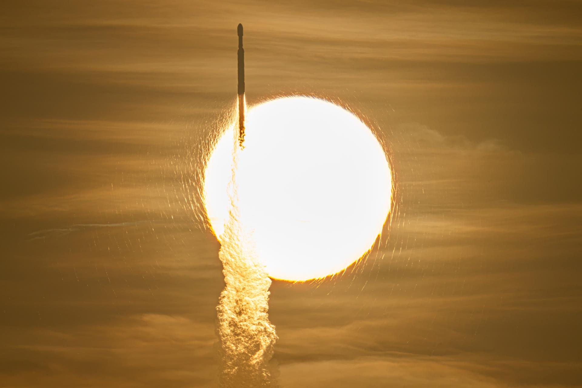
A SpaceX Falcon Heavy rocket with NASA’s Nancy Grace Roman Telescope on board is seen transiting the sun during launch from Launch Complex 39A, Sunday, Aug. 30, 2026, at NASA’s Kennedy Space Center in Florida.
NASA/John Kraus

Now on a three-month, million-mile journey to its final orbit, NASA’s Nancy Grace Roman Space Telescope will soon reveal the universe’s darkest secrets. The mission launched at 7:26 a.m. EDT Sunday aboard a SpaceX Falcon Heavy rocket from Launch Complex 39A at the agency’s Kennedy Space Center in Florida.

Roman pairs a large field of view with crisp infrared vision to explore vast swaths of the sky and probe deeply into cosmic history. This flagship mission will help astronomers explore dark matter, dark energy, and worlds outside of our solar system, known as exoplanets. Its surveys will support a broad range of research extending far beyond the mission’s main science goals.

“Roman is exactly the kind of success story we want to see across NASA,” said NASA Administrator Jared Isaacman. “Delivered ahead of schedule and on budget, this mission reflects more than a decade of dedication from the NASA workforce and our industry partners. Now, Roman will give us a new atlas of the universe, push the boundaries of discovery, and demonstrate what is possible when America’s space program pairs bold ambition with disciplined execution.”

The ground control team at NASA’s Goddard Space Flight Center in Greenbelt, Maryland, began receiving telemetry data from Roman seven minutes after launch. The Falcon Heavy rocket performed as expected, separating from the observatory 31 minutes into the flight. After separating from the center core, the rocket’s boosters safely returned to the launch site for refurbishment.

“Roman will be a discovery machine that will bring us closer than ever before to answering humanity’s most profound questions about our cosmic history,” said Nicky Fox, associate administrator for the Science Mission Directorate at NASA Headquarters in Washington. “With its large field of view and fast survey speeds, Roman will usher us into a new era of discovery and make the invisible visible, setting the foundation for humanity’s search for life beyond our solar system.”

During launch and early orbit, Roman uses the Near Space Network’s ground stations and relay satellites to exchange tracking, telemetry, and command data with ground controllers. About 70 minutes after launch, the Deep Space Network takes over communications and guides Roman toward the second Sun-Earth Lagrange point, or L2, about one million miles from Earth. Roman connects to that network through the Canberra Deep Space Communication Complex in Australia first. Approximately six hours later it will transfer to the Madrid Deep Space Communication Complex in Spain and then to the Goldstone Deep Space Communication Complex in California, ensuring continuous contact with Roman throughout its journey.

The Roman team also confirmed successful deployment of the observatory’s solar panels and lower instrument sun shade an hour and 23 minutes after launch. Within the upcoming days, Roman’s high-gain antenna and visor-like deployable aperture cover will deploy, ground controllers will initiate the first of two-mid-course corrections, and the Coronagraph Instrument will power on. This instrument will demonstrate the technology that future missions like NASA’s Habitable Worlds Observatory concept could use to image Earth-like planets in the search for life in the universe. Roman’s Coronagraph will take a giant step in that direction by snapping pictures of Jupiter-like planets.

A few weeks into Roman’s voyage, its primary instrument, the Wide Field Instrument, will activate. This 300-megapixel infrared camera has 18 4K detectors, each about the size of a saltine cracker. These detectors collect photons of light that will be decoded into crisp cosmic panoramas. Thanks to the observatory’s rigid design and stable optical performance, it will rapidly scan the sky without needing substantial time between separate observations. The Roman telescope is designed to survey the universe a thousand times faster than NASA’s Hubble Space Telescope.

Throughout the rest of Roman’s three-month commissioning period, scientists will run the instruments through a series of calibrations and tests. NASA anticipates releasing Roman’s first images by early 2027.

Roman will send back 1.4 terabytes of data every day, the highest data rate of any NASA astrophysics mission, so far. Machine learning, artificial intelligence, and citizen scientists will help sift through it and flag significant findings, which astronomers can then study.

“We’ve never been able to view the universe with eyes like Roman’s before,” said Julie McEnery, Roman’s senior project scientist at NASA Goddard. “There’s no telling what more we’ll know and have seen by this time next year.”

Roman is the fourth primary mission NASA has launched on a Falcon Heavy rocket. Earlier this year, the agency’s Launch Services Program worked with SpaceX to accelerate the launch date to accommodate the space telescope’s early completion.

The telescope is managed at NASA Goddard with participation by the agency’s Jet Propulsion Laboratory in Southern California; Caltech/IPAC in Pasadena, California; the Space Telescope Science Institute in Baltimore; and a team of scientists from various research institutions. The primary industrial partners are BAE Systems Inc., L3Harris Technologies, and Teledyne Scientific & Imaging. Contributions to Roman also are made by ESA, JAXA, the French space agency CNES (Centre National d’Études Spatiales), and the Max Planck Institute for Astronomy in Germany.

To learn more about the Roman mission, visit:

https://www.nasa.gov/roman

-end-

George Alderman / Alise Fisher
Headquarters, Washington
202-358-1600
george.a.alderman@nasa.gov / alise.m.fisher@nasa.gov

Claire Andreoli
Goddard Space Flight Center, Greenbelt, Md.
202-286-1940
claire.andreoli@nasa.gov

New Next-Gen Dish Adds Muscle to NASA’s Deep Space Network

By: albarne1
25 August 2026 at 18:28
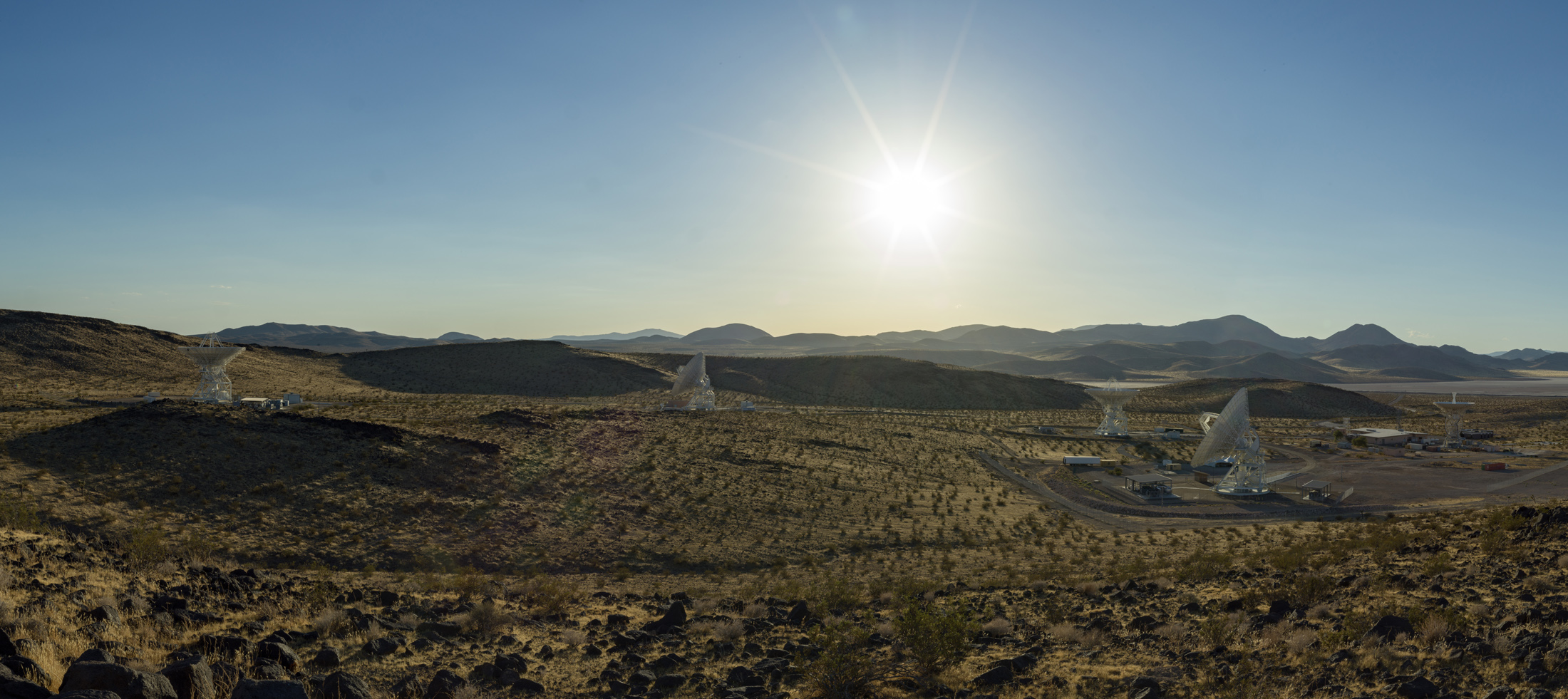
A wide desert landscape featuring several large white satellite dishes pointing toward a bright sun shining in a clear blue sky above distant mountain ranges.
Antennas soak in the summer Sun in August 2026 at the Deep Space Network’s Goldstone complex near Barstow, California, including the recently completed Deep Space Station 23 (shown in the foreground, to the right).
NASA/JPL-Caltech

NASA’s Deep Space Network facility in California is marking the addition of a brand new 34-meter-wide (114-foot-wide) radio frequency antenna to the agency’s deep space communications and navigation system. The network uses giant dish antennas located at three global facilities to support more than 40 spacecraft exploring the solar system and interstellar space.

The new Deep Space Station 23 (DSS-23) is located at the Goldstone Deep Space Communications Complex, near Barstow, and is managed by NASA’s Jet Propulsion Laboratory in Southern California.

NASA leadership and personnel as well as dignitaries gathered at the complete DSS-23 antenna for a ceremonial ribbon cutting. It’s the latest to be added as part of the Deep Space Network’s Aperture Enhancement Project, which began in 2009 to upgrade and expand the network by adding six new 34-meter multifrequency beam-waveguide antennas. These versatile dishes can enhance many missions operating over different radio frequencies.

“By expanding the Deep Space Network, we are strengthening the communications foundation NASA needs for the bold missions ahead — from exploring more of the Moon than ever before to peering deeper into the solar system,” said James Kenyon, associate administrator of the Research and Technology Mission Directorate at NASA Headquarters in Washington. “This new antenna will help us deliver on our national goals for space exploration and push beyond the limits of what once seemed impossible.”

After completing a testing campaign from May through July to demonstrate its capabilities, the new DSS-23 began operations on Aug. 3, tracking NASA’s Chandra X-ray Observatory. Since then, it has been communicating with dozens of missions such as NASA’s Mars Reconnaissance Orbiter, Psyche, Juno, Voyager 1, and other robotic spacecraft in deep space.

A massive white satellite dish antenna stands on a desert plain under a clear blue sky, bathed in warm sunlight alongside small facility structures.
Long shadows are cast by the recently completed Deep Space Station 23 at the Deep Space Network’s Goldstone complex near Barstow, California. A multifrequency beam waveguide antenna, DSS-23 will boost the DSN’s capacity and enhance NASA’s deep space communications capabilities for decades to come.
NASA/JPL-Caltech
Ten people in professional attire pose together outside under a clear blue sky, with a massive white satellite dish standing directly behind them.
NASA, Jet Propulsion Laboratory, and Deep Space Network leadership pose in front of the recently completed Deep Space Station 23 (DSS-23) antenna at the Deep Space Network’s Goldstone complex near Barstow, California, on Aug. 25, 2026..
NASA/JPL-Caltech

“The addition of this next-generation antenna brings us closer to a completely modernized network that embraces advanced technology to ensure NASA’s leadership in deep space communications,” said Dave Gallagher, director of JPL. “After over 60 years of continuous operations supporting consequential missions, these upgrades prime the network for a new era of exploration. The teams that designed, planned, and built DSS-23 should be proud.”

Enhanced capabilities

Construction of DSS-23 began in February 2020. After the 133-ton metal reflector framework was placed and bolted atop the antenna’s pedestal in December 2024, engineers installed the panels to the framework that reflect radio frequency signals transmitted to and received from spacecraft. Then came the careful process of calibrating the antenna so it can work in concert with the rest of the network.

It is the fifth antenna at Goldstone (joining three 34-meter antennas and one 70-meter, or 230-foot, antenna) and the fifth enhancement project antenna to join the network, which includes antennas at the DSN’s Goldstone, Madrid, and Canberra, Australia, complexes. Multifrequency beam waveguide antennas direct signals down to a stable, climate-controlled underground room, rather than housing heavy, sensitive electronic equipment on the moving antenna dish. In addition to offering versatility, this design allows easy access for maintenance and upgrades to the system.

“The biggest challenge wasn’t actually constructing the antenna. It was transforming a complex collection of mechanical, electrical, software, radio frequency, and infrastructure systems into a single, mission-ready asset,” said Germaine Aziz, manager of the Deep Space Network Aperture Enhancement Project at JPL. “Every subsystem must be integrated, calibrated, and verified to operate with extraordinary precision and reliability before it can support NASA’s deep space missions.”

The enhancement project will be complete when a sixth enhancement-project antenna, Deep Space Station 33, comes online at the Canberra facility in 2029, bringing the total number of 34-meter antennas across the network to 13. The 34-meter antennas can be arrayed (combined and operated together) to provide an equivalent communications backup for each facility’s single 70-meter antenna, which, after more than 50 years of near-continuous operation, are getting increasingly costly to maintain and repair.

Managed by Caltech for NASA, JPL manages the agency’s Deep Space Network with the oversight of NASA’s SCaN (Space Communications and Navigation) Program within NASA’s Research and Technology Mission Directorate. More than 100 NASA and non-NASA missions rely on the Deep Space Network and Near Space Network. They include missions that support astronauts aboard the International Space Station and future Artemis missions, monitoring Earth, exploring the Moon, and exploring the solar system and beyond. 

For more information about the Deep Space Network, visit:

https://www.nasa.gov/communicating-with-missions/dsn

NASA Sets Coverage for Roman Space Telescope Launch from Florida

24 August 2026 at 16:44
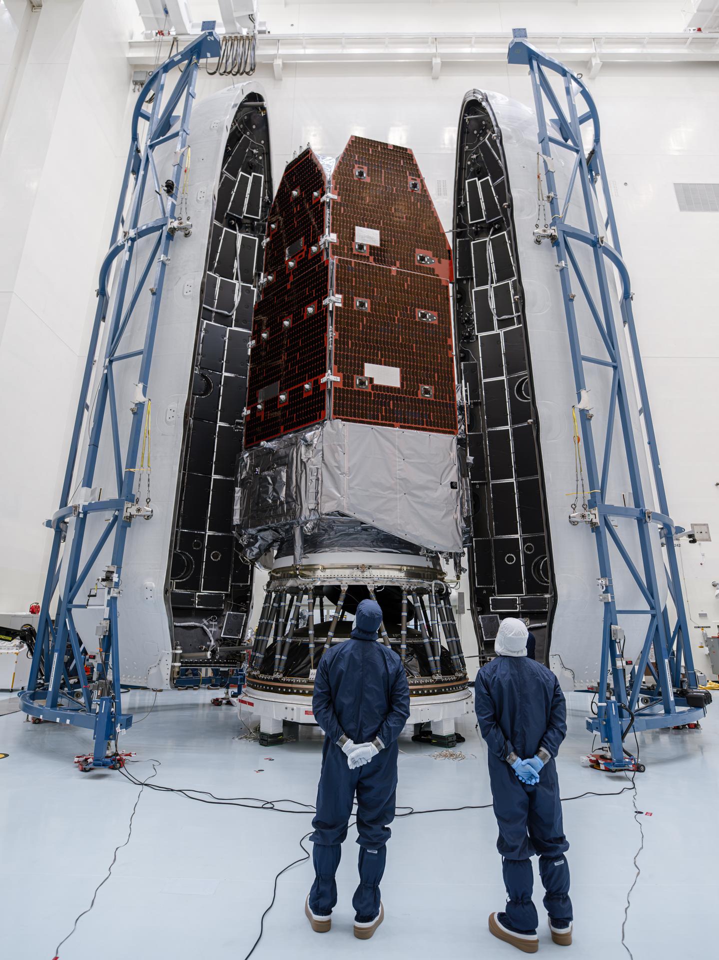
NASA’s Nancy Grace Roman Space Telescope is encapsulated within the payload fairing at the agency’s Kennedy Space Center in Florida, ahead of mating to a SpaceX Falcon Heavy rocket for launch.
Credit: NASA/Sydney Rohde (Rocz)

Coverage plans are ready for NASA’s Nancy Grace Roman Space Telescope prelaunch and launch activities. Roman is NASA’s next-generation observatory designed to explore some of the universe’s biggest mysteries, including dark energy.

NASA and SpaceX are targeting Roman’s liftoff for no earlier than 7:26 a.m. EDT Sunday, Aug. 30, aboard a SpaceX Falcon Heavy rocket from Launch Complex 39A at the agency’s Kennedy Space Center in Florida. Launch coverage begins at 6:20 a.m.

Live coverage of these events will stream through a variety of platforms. Learn where to watch online:

https://www.nasa.gov/live

Named for NASA’s first chief astronomer, the Nancy Grace Roman Space Telescope will pair sharp infrared vision with a field of view at least 100 times larger than the agency’s Hubble Space Telescope. Its crisp, sweeping surveys will help scientists investigate dark energy and dark matter, discover and characterize exoplanets, map billions of galaxies, study black holes, and explore objects from our own solar system to the edge of the observable universe.

After launch and separation from the rocket, Roman will travel to the second Sun-Earth Lagrange point, or L2, about one million miles from Earth. The mission has a five-year primary lifetime with a goal of operating for 10 years, and Roman’s science data will be publicly available after processing.

NASA’s mission coverage is as follows (all times are Eastern and subject to change based on real-time operations):

Saturday, Aug. 29

9 a.m.: NASA’s Roman Space Telescope Mission Science Briefing: The briefing will take place in the NASA Kennedy Press Site auditorium with the following participants:

  • Shawn Domagal-Goldman, director, Astrophysics Division, NASA Headquarters
  • Julie McEnery, Roman telescope senior project scientist, NASA Goddard Space Flight Center
  • Vanessa Bailey, Roman Coronagraph Instrument scientist, NASA Jet Propulsion Laboratory
  • Kristen McQuinn, Roman Science Operations Center lead, Space Telescope Science Institute
  • Lee Armus, Roman Science Support Center lead, Caltech/IPAC

Media may ask questions in person or by phone. Limited auditorium space will be available for in-person participation. For the dial-in number and passcode, media should contact the NASA Kennedy newsroom no later than one hour before the briefing at: ksc-newsroom@mail.nasa.gov.

10:30 a.m.: NASA’s Roman Space Telescope Prelaunch News Conference: The news conference will take place in the NASA Kennedy Press Site auditorium with the following participants:

  • Nicky Fox, associate administrator, Science Mission Directorate, NASA Headquarters
  • Lucas Paganini, Roman telescope program executive, NASA Headquarters
  • Jackie Townsend, Roman telescope project manager, NASA Goddard
  • Denton Gibson, launch director, NASA’s Launch Services Program, NASA Kennedy
  • Julianna Scheiman, director, NASA Science and Dragon Programs, SpaceX
  • Justin McReynolds, launch weather officer, 45th Weather Squadron, U.S. Space Force

Media may ask questions in person or by phone. Limited auditorium space will be available for in-person participation. For the dial-in number and passcode, media should contact the NASA Kennedy newsroom no later than one hour before the briefing at: ksc-newsroom@mail.nasa.gov.

11:45 a.m.: NASA Administrator Jared Isaacman is expected to fly past the Nancy Grace Roman Space Telescope and Falcon Heavy rocket on the launchpad in his jet. The flyby will be shown live on the same stream as the prelaunch news conference, with a view of the launch pad during the transition. The flyby is subject to weather and operational considerations.

12 p.m.: In-person interviews will take place in the NASA Kennedy Press News Center:

  • Nicky Fox, associate administrator, Science Mission Directorate, NASA Headquarters
  • Lucas Paganini, Roman telescope program executive, NASA Headquarters
  • Dalia Kirschbaum, acting director, Sciences and Exploration Directorate, NASA Goddard
  • Josh Schlieder, Roman telescope project scientist, NASA Goddard
  • Jason Hylan, Roman telescope flight segment and observatory manager, NASA Goddard
  • Bertrand Mennesson, Roman Coronagraph Instrument project scientist, NASA JPL
  • Jeff Hanke, president, Space Systems, Space and Mission Systems, L3Harris Technologies 
  • Wendy Minotti, program manager, Exquisite Imaging, Space and Mission Systems, L3Harris Technologies
  • Bonnie Patterson, vice president and general manager, Civil Space, Space and Mission Systems, BAE Systems
  • Sarah Lipscy, director, Strategic Operations, Space and Mission Systems, BAE Systems

Previously credentialed media interested in scheduling an interview should contact the NASA Kennedy newsroom at: ksc-newsroom@mail.nasa.gov.

Sunday, Aug. 30

6:20 a.m.: Launch coverage begins.

7:26 a.m.: Launch

9:30 a.m.: Postlaunch news conference with the following participants:

  • NASA Administrator Jared Isaacman
  • Nicky Fox, associate administrator, Science Mission Directorate, NASA Headquarters
  • Jackie Townsend, Roman telescope project manager, NASA Goddard
  • Julie McEnery, Roman telescope senior project scientist, NASA Goddard
  • Denton Gibson, launch director, NASA’s Launch Services Program, NASA Kennedy

Media may ask questions in person or by phone. Limited auditorium space will be available for in-person participation. For the dial-in number and passcode, media should contact the NASA Kennedy newsroom no later than one hour before the news conference at: ksc-newsroom@mail.nasa.gov.


Audio-only coverage

Audio-only coverage of the launch will be carried on the NASA “V” circuits, accessible by dialing 321-867-1220 or 321-867-1240. On launch day, mission audio countdown activities without NASA broadcast commentary will be carried on 321-867-7135.

Launch audio also will be available on Launch Information Service and Amateur Television System’s VHF radio frequency 146.940 MHz and KSC Amateur Radio Club’s UHF radio frequency 444.925 MHz, FM mode, heard within Brevard County on the Space Coast.

NASA website launch coverage

Launch day coverage will be available on the NASA website, including the livestream and blog updates as countdown milestones occur. On-demand streaming video and launch photos will be available shortly after liftoff. Follow mission updates on the Roman launch blog.

Attend launch virtually

Members of the public may register to attend the Roman launch virtually. NASA’s Virtual Guest Program includes curated launch resources, notifications about related opportunities or schedule changes, and a stamp for the NASA virtual guest passport following launch.

Watch, engage on social media

Let people know you’re watching the mission on X, Facebook, and Instagram by following and tagging these accounts:


The Roman telescope is managed at NASA Goddard with participation by the agency’s Jet Propulsion Laboratory in Southern California; Caltech/IPAC in Pasadena, California; the Space Telescope Science Institute in Baltimore; and a team of scientists from various research institutions. The primary industrial partners are BAE Systems Inc., L3Harris Technologies, and Teledyne Scientific & Imaging. Contributions to Roman also are made by ESA (European Space Agency), JAXA (Japan Aerospace Exploration Agency), the French space agency CNES (Centre National d’Études Spatiales), and the Max Planck Institute for Astronomy in Germany. NASA’s Launch Services Program, based at Kennedy, manages the launch service for the Roman mission.

For more information about NASA’s Roman telescope, visit:

https://www.nasa.gov/roman

-end-

Alise Fisher
NASA Headquarters, Washington
202-385-1287
alise.m.fisher@nasa.gov

Leejay Lockhart
Kennedy Space Center, Fla.
321-747-8310
leejay.lockhart@nasa.gov

Claire Andreoli
Goddard Space Flight Center, Greenbelt, Md.
301-286-1940
claire.andreoli@nasa.gov

NASA Mission Studies Air Pollution Over Ethiopia

17 August 2026 at 15:24

5 min read

Preparations for Next Moonwalk Simulations Underway (and Underwater)

A busy street in Addis Ababa, Ethiopia’s capital, which is the subject of NASA-led air quality research.
Ninaras (CC BY-SA 4.0)

A NASA-funded air pollution monitoring network has provided one of the most detailed long-term views yet of the role of black carbon, or soot produced by fires, diesel vehicles, and other combustion sources, in Ethiopia’s capital, Addis Ababa. The detailed measurements show how pollution changes by time of day and season, including increases associated with rush-hour traffic and holiday celebrations. The findings are relevant to cities around the world, including in the United States.

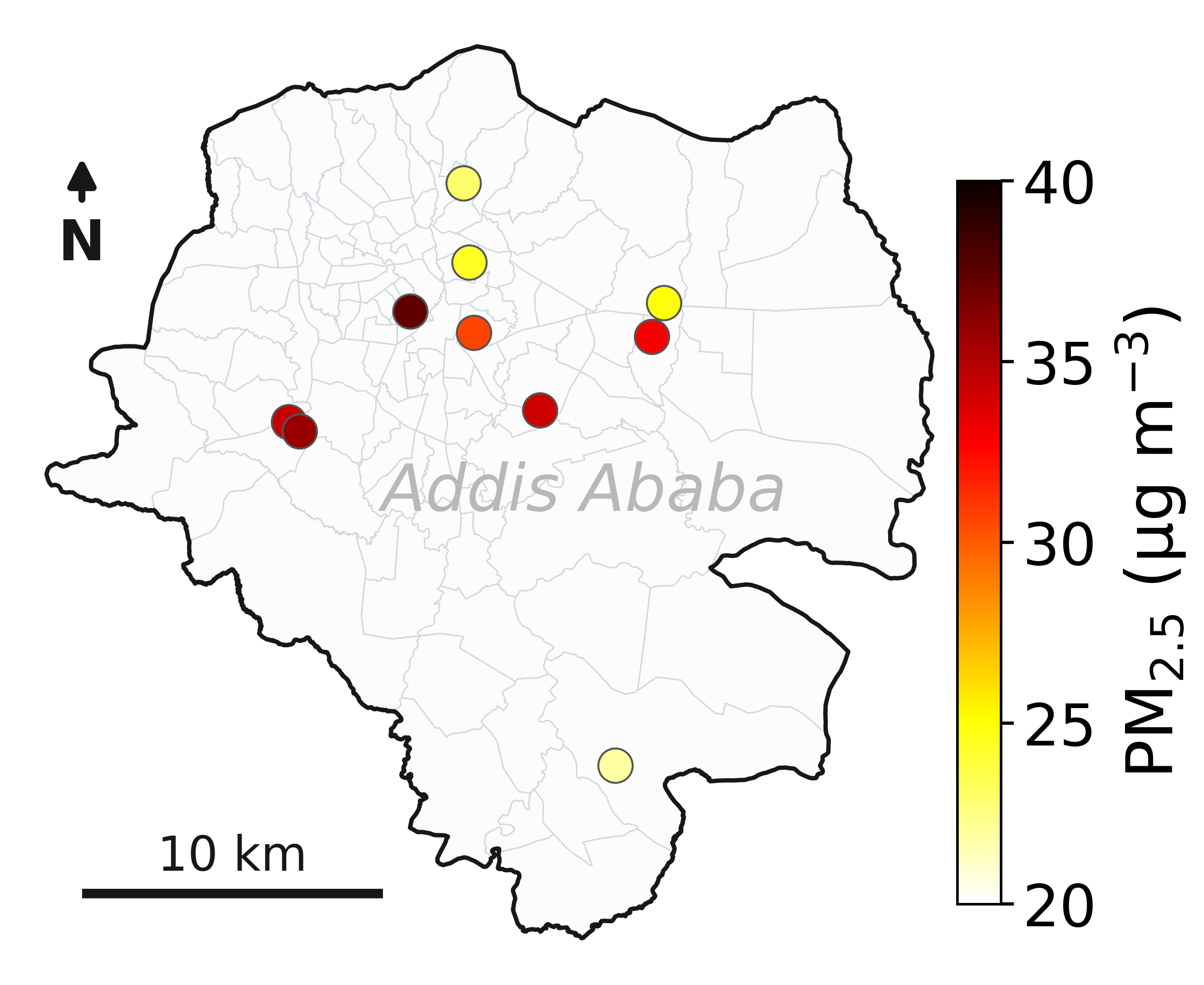
In a new paper published in ES&T: Air, scientists analyzed data collected throughout Addis Ababa between 2022 and 2025 from 10 air-quality monitoring sites deployed by NASA’s Multi-Angle Imager for Aerosols (MAIA) project.

The research comes as Ethiopia is taking steps aimed at improving air quality. In 2024, the country became the first in the world to ban the import of internal combustion engine vehicles, while cities have been adding bike lanes and electric vehicle infrastructure. The MAIA project’s measurements provide researchers with a baseline for understanding how air quality changes over time as Addis Ababa continues to grow and evolve.

The study focuses on particulate matter that is 2.5 micrometers or less in diameter, also known as PM2.5. The 2025 State of Global Air Report, cited in the paper, estimates that exposure to PM2.5 is associated with approximately 4.9 million deaths globally each year. Among the many kinds of PM2.5, black carbon has been has been studied for its potential effects on human health.

The paper found that Addis Ababa’s three-year average PM2.5 concentration was 30 micrograms per cubic meter, which is more than three times the level of the U.S. Environmental Protection Agency’s health-based annual PM2.5 standard. The new paper cites data from MAIA’s ground sensors indicating that average black carbon levels in Addis Ababa were approximately four to nine times higher than those measured in the three U.S. metropolitan areas the mission is monitoring.

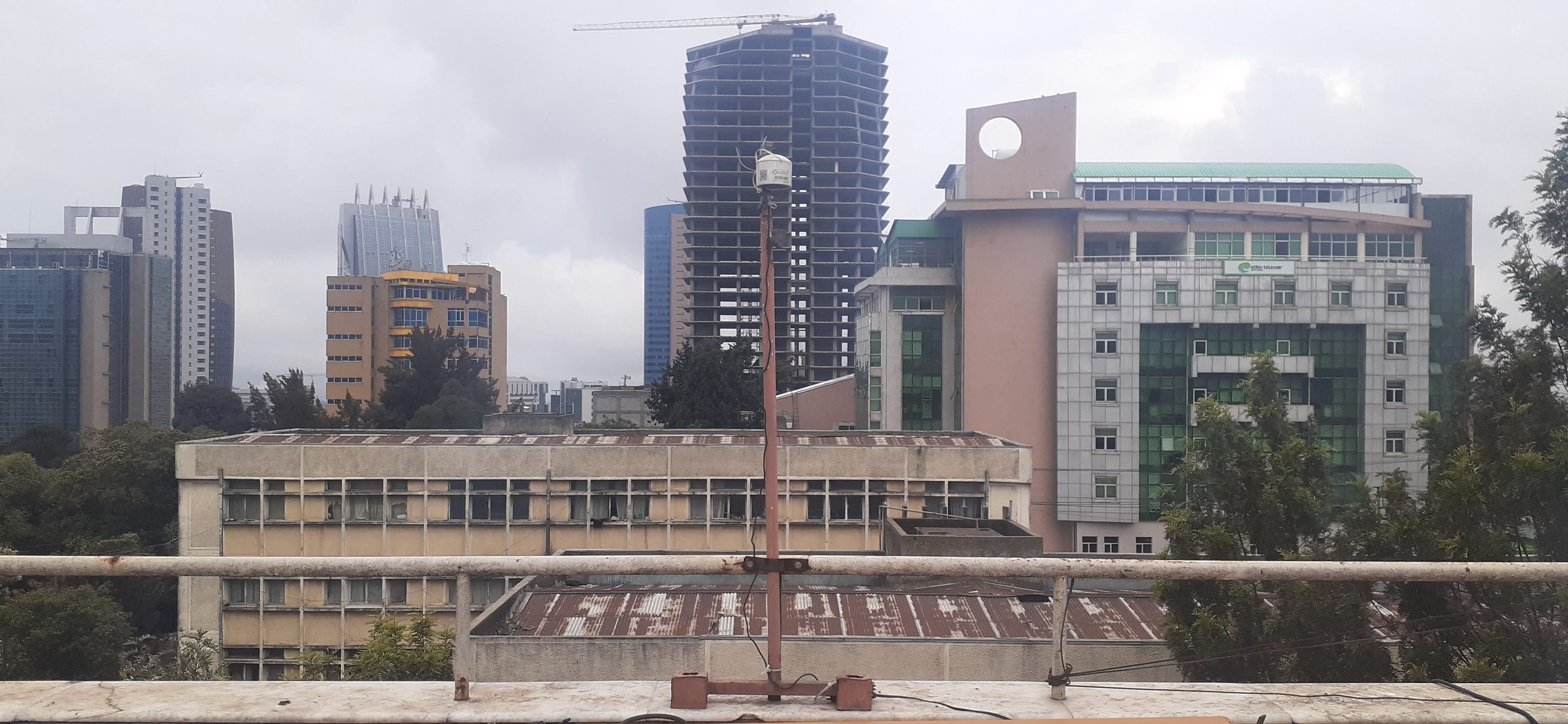
An air quality monitoring sensor mounted on a rooftop stands in front of a dense urban skyline, capturing atmospheric data. The sensor is semi-cylindrical white object several inches across, mounted on a tall rust-colored pole.
This roof-mounted air sensor in Addis Ababa, the capital of Ethiopia, is one of 10 used by NASA’s MAIA mission to study the city’s air quality. MAIA’s air sensors provide a detailed look at PM2.5, one of the world’s deadliest forms of air pollution.
NASA/JPL-Caltech

“To our knowledge, this is the first long-term, multisite study of continuous PM2.5 and black carbon measurements in Ethiopia,” said Sina Hasheminassab, a coauthor of the paper and MAIA’s deputy principal investigator at NASA’s Jet Propulsion Laboratory in Southern California. “Many rapidly growing cities have limited long-term monitoring, so these measurements provide an important baseline for understanding how pollution changes across space and time.”

The composition and sources of PM2.5 can differ substantially between cities, depending on their local geography, traffic, industries, and more. Desert cities, for example, may have more dust, while those near coal-fired power plants may have higher concentrations of sulfate. Long-term surface measurements remain limited in many parts of the world.

NASA is supporting MAIA’s air pollution research in a dozen metropolitan areas around the globe, including three in the U.S.: Los Angeles, Atlanta, and Boston. The mission consists of a ground-based network of sensors already in operation as well as a space observatory, which uses a JPL-built camera that will be launched by the Italian Space Agency (ASI) on an ASI satellite no earlier than late 2027.

The camera is designed to identify different types of PM2.5 aerosols based on how they reflect light, making it possible to map particle concentrations over each city that the mission studies. Mounted on a gimbal, the camera captures data from multiple angles using JPL-pioneered technologies that make particles stand out more prominently against the surface background to provide valuable information about their shape and size.

The MAIA mission is the first NASA project to include public health researchers among a space mission’s team. These researchers will use MAIA’s PM2.5 concentration maps alongside health data to study potential relationships between different particle types and health outcomes. By developing a better understanding of particulate matter pollution, researchers can potentially advance how air quality is studied and managed.

“This paper shows how valuable the air sensor data is on its own, but combining the sensor network and satellite observations will be a game-changer,” said, Kyan Shlipak, the paper’s lead author, who worked on the research while interning at JPL.

Tracking black carbon

The greater Addis Ababa urban area is home to nearly 6 million people, and according to United Nations projections, that figure is expected to surpass 10 million by 2050.

This map of Addis Ababa, the capital of Ethiopia, shows the locations of 10 air sensors that NASA’s MAIA mission is using to provide one of the most detailed looks ever at the city’s air pollution.
NASA/JPL-Caltech

“It’s a cosmopolitan city with many international communities,” said Araya Asfaw of Addis Ababa University, a coauthor of the paper and the MAIA project’s lead Ethiopian collaborator. “Think of it as Africa’s version of Brussels, where the European Union is based.”

“Even at night, when traffic dies down, you see high emissions from the burning of charcoal and other fuels,” Asfaw said.

The MAIA sensor network detected increases in black carbon during two major holidays in Addis Ababa that involve bonfires and was able to distinguish between particles originating from the fires and those from fossil fuel combustion. The findings demonstrate how detailed measurements can help researchers identify different sources of particulate matter and better understand how air quality varies across a city and over time.

To learn more about MAIA, visit:

https://science.nasa.gov/mission/maia/

2026-056

NASA’s Perseverance Rover Watches Earth Vanish Behind Martian Moon

5 August 2026 at 11:25

3 min read

Preparations for Next Moonwalk Simulations Underway (and Underwater)

A desolate landscape with a dark horizon sits under a hazy, gray-blue sky. A large rectangular inset in the sky, connected by lines to a smaller rectangle, shows a sequence of five faint crescent shapes with a tiny bright dot moving downward.
This annotated composite of nine images taken by Perseverance’s Mastcam-Z on July 2, 2026, shows Earth — the small bright dot moving from upper left to lower right — passing behind the Martian moon Phobos. The images in the inset were captured from the same rectangular patch of sky outlined in black.
NASA/JPL-Caltech/ASU/MSSS/SSI
A dark horizon under a hazy gray-blue sky. A red-outlined rectangular inset, connected by lines to a smaller rectangle, shows five faint crescent shapes with a bright dot moving downward. Timecodes beneath each crescent indicate a span of 40 seconds.
The timecode annotations in the inset show the local solar time on Mars during which five individual images of the occultation were captured by NASA’s Perseverance on July 2, 2026. Earth disappears — and then reappears — behind the Martian moon Phobos.
NASA/JPL-Caltech/ASU/MSSS/SSI

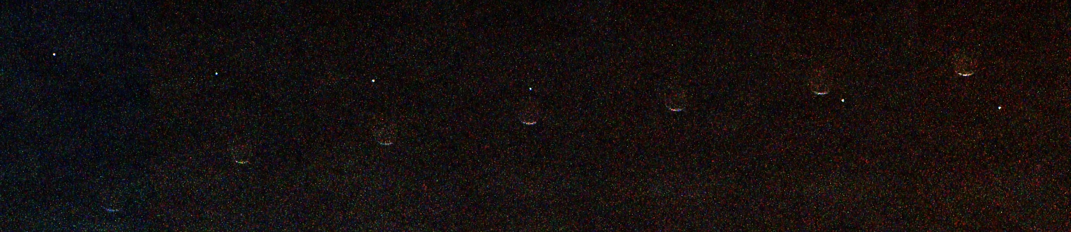
Earth and the Martian moon Phobos dance together in a series of images recently acquired by NASA’s Perseverance Mars rover. Earth appears as a point of light in the Martian sky, disappearing behind the crescent of Phobos, the larger of Mars’ two moons.

This is the first time humanity has captured from the surface of another planet an observation of Earth disappearing behind an object.

The image sequence was taken by the rover’s Mastcam-Z instrument at about 7 p.m. local solar time (the Martian evening time where the rover is located) on July 2, the 1,907th Martian day, or sol, of the mission. In the composite image, Earth travels from the upper left of the frame toward the lower right while Phobos, moving from lower left to upper right, sweeps across its path. In the third frame of the sequence, the two meet, and our planet winks out behind the little moon’s shadowed edge.

“The composite image makes for a unique Earth self-portrait, taken from the surface of another planet, with a Phobos photobomb,” said Justin Maki, the Mastcam-Z deputy principal investigator and imaging scientist for Perseverance at NASA’s Jet Propulsion Laboratory in Southern California.

From where Perseverance sits on the rim of Mars’ Jezero Crater, the two objects could hardly look more different. Phobos, a lumpy, potato-shaped moon about 17 miles (27 kilometers) across at its widest, orbits so close to Mars (4,850 miles, or 7,800 kilometers, away) that when the images were taken, Phobos appears roughly one-third the width of Earth’s Moon as seen from our planet. Some 195 million miles (314 million kilometers) away at the time, Earth is reduced to a single, pixel-size dot.

“Phobos crosses the Martian sky three times a day, and Earth is visible for months at a stretch, but catching one directly behind the other takes planning and a little luck,” said Mark Lemmon, a Mastcam-Z co-investigator at the Space Science Institute in Boulder, Colorado, who planned the observation and assembled the composite.

A grainy black image showing a horizontal sequence of seven faint crescent shapes evenly spaced from left to right. A tiny bright white dot moves diagonally from the upper left to the lower right, appearing to pass behind the crescent shapes.
This composite of seven images of Earth passing behind the Martian moon Phobos was acquired from data taken on July 2, 2026, 1,907th Martian day, or sol, of the mission. The black background is the result of image processing that removed extraneous light in the background to enhance detail.
NASA/JPL-Caltech/ASU/MSSS/SSI

Transits, occultations, eclipses

Astronomers call the event captured in this observation an occultation: when a larger-appearing body completely blocks the one behind it from the viewer’s standpoint. By contrast, an eclipse occurs when one object moves into the shadow of another. When the Moon passes through Earth’s shadow, it’s called a lunar eclipse; when one object that appears to be the same size as another blocks it, like when the Moon passes before the Sun, it’s known as a solar eclipse.

When the roles are reversed, with a smaller-looking object crossing the face of a larger-looking one, astronomers call that a transit. Perseverance has observed those, too: when Phobos or Deimos crosses the disk of the Sun as seen from Mars. These are sometimes described informally as “Martian solar eclipses.”

More about Perseverance

NASA’s Jet Propulsion Laboratory in Southern California, which is managed by Caltech, built and manages operations of the Perseverance rover on behalf of the agency’s Science Mission Directorate in Washington, as part of NASA’s Mars Exploration Program portfolio. Arizona State University leads the operations of the rover’s Mastcam-Z instrument, working in collaboration with Malin Space Science Systems in San Diego, on the design, fabrication, testing, and operation of the cameras.

For more about Perseverance:

https://science.nasa.gov/mission/mars-2020-perseverance

News Media Contacts

DC Agle
 
Jet Propulsion Laboratory, Pasadena, Calif.
818-393-9011

agle@jpl.nasa.gov 

Karen Fox / Alana Johnson
NASA Headquarters, Washington 
240-285-5155 / 202-672-4780
karen.c.fox@nasa.gov / alana.r.johnson@nasa.gov 

2026-054

❌
❌