Silicon Valley is shifting away from chatbot queries toward a future filled with resource-intensive agentic AI—and it's driving the data center buildout.
Longtime Slashdot reader fahrbot-bot shares a report from ScienceAlert: Scientists have now demonstrated one of the weirdest forms of ice yet -- under preposterous pressures up to 2.3 million atmospheres, and tremendous temperatures up to 2,630 kelvins (2,357 degrees Celsius, or 4,274 degrees Fahrenheit). [...] In their new experiments, a team led by physicist Alexis Forestier of the French Alternative Energies and Atomic Energy Commission subjected tiny samples of water to the sorts of extreme conditions expected in the interiors of ice giant planets.
They squeezed the samples between the tips of diamonds to pressures as high as 230 gigapascals, while using lasers to heat them to thousands of degrees. That's 2.3 million times Earth's atmospheric pressure at sea level â" the pressure at the center of Earth, for context, is around 360 gigapascals. Then, using an extremely narrow beam of synchrotron X-rays, they probed for changes in the crystal structure of the ice.
What emerged was a configuration predicted theoretically but never unambiguously observed in experiments: hexagonal close-packed, or hcp, ice. As the hcp crystal was heated, its expansion also showed a signature of superionic behavior, suggesting it entered the superionic state at around 1,700 kelvins. [Superionic ice is thought to exist deep inside Uranus and Neptune, where its unusual properties may play a role in generating the planets' equally unusual magnetic fields.] The findings have been published in Physical Review Letters.
Launched in 1976, LAGEOS-1 (LAser GEOdynamic Satellite) is unusual in that it contains no instrumentation, no electronics, no power supply, and no means of propulsion. It’s spherical, weighs just under 407 kg, and looks a bit like a disco ball. It may not be accurate to say it does nothing, but unlike most satellites its role is entirely passive. It’s also one of the oldest scientific satellites still in service.
The lens-like objects covering the surface of LAGEOS-1 are corner cube retroreflectors, which have the nifty effect of always reflecting incident light right back towards its source.
Ground stations fire short laser pulses at it and measure the time it takes for the light to return, a form of time-of-flight ranging. Since LAGEOS-1’s orbit is highly stable, it provides a reliable reference point for measuring even tiny changes in the Earth itself. The size, shape, rotation, and more of our planet can be measured as a result. LAGEOS data (LAGEOS-2 was launched in 1992) has also been used in tests of general relativity.
Its orbit and construction were deliberately chosen so that atmospheric drag and other disturbances would be minimal. The simple, maintenance-free design combined with an extraordinarily stable orbit means LAGEOS is expected to circle our world for millions of years to come.
LAGEOS-1 also contains a message to the future in the form of two identical plaques prepared by Dr. Carl Sagan just in case there’s anyone around to find it some day. Check out the short 1975 video from NASA, embedded just below.
Steven Strogatz coauthored a book about how math is moving beyond human understanding. He spoke with WIRED about the seismic impact artificial intelligence has had on his life’s work.
If you ask most satellite companies aside from SpaceX, they will tell you the world doesn't have enough capacity for launching payloads into orbit. This is despite the blistering launch cadence we've seen around the world in recent years, led by SpaceX's Falcon 9 rocket.
Customers in any sector will, of course, usually welcome competition. Theoretically, competition will lead to lower prices and allow the best to rise to the top. It seems like the customers buying launch services were right. SpaceX is dialing back its Falcon 9 launch program, and there is no certainty about when SpaceX's reusable next-generation super-heavy-lift rocket, Starship, will carry anything to orbit besides the company's own Starlink satellites.
So it's no surprise satellite operators are cheering the success of a new launch provider. This was especially the case a few days ago, when Germany's Isar Aerospace reached orbit for the first time with its Spectrum rocket. The launcher delivered a batch of CubeSats to low-Earth orbit from a spaceport in northern Norway, and Isar tasted success after its first test flight ended in failure last year.
Games may be life with all the hard bits removed, but they provide a way to study why people make the choices they make. Traditional games are usually played against a static background: the rewards per outcome are constant. That limits their relevance to behavior because, in real life, the rewards and consequences of strategic choices are ever changing. Now, researchers have used a mathematical model to study a series of games that include evolving strategies and randomly varying returns.
A bit of history
Perhaps the most famous game-theory contest is the prisoner’s dilemma. In the prisoner’s dilemma, a pair of thieves have been captured and are being separately interrogated by the police. If both clam up, they will be punished for a lesser crime. If one prisoner makes a deal (defects) then that prisoner gets to go free and the other gets a heavier sentence. If both make a deal, they both get an in-between punishment.
The person running the game can start it with different rewards for cooperating and defecting to explore how the optimum strategy varies with reward and risk, which the players can figure out by varying the strategies across multiple rounds. Depending on the balance between the reward for staying silent (cooperating) and betrayal, the game stabilizes with everyone betraying everyone. In this simple situation, everyone loses.
The use of coal to generate electricity on the US grid has been plunging for nearly two decades, and the first Trump administration was unable to affect the trend. So his second administration has attempted more aggressive interventions to prop up coal use. One of its most direct means of doing so is to order coal plants that were scheduled to close to remain open, even if there is no need for them.
The administration's justification for these orders is a statute that allows the Department of Energy (DOE) to declare an emergency in the case of wartime or a sudden shortfall in generation. A number of parties, including states where coal plants have been slated to close, have challenged this declaration. And on Friday, in the first of these cases to make its way through the courts, the declaration was judged to be contrary to the statute. While this only affects a single coal plant in Michigan, the reasoning of the decision will apply to every coal plant closure that has been blocked by the DOE.
No emergency
The decision was issued by a unanimous three-judge panel from the DC Circuit's Court of Appeals. It focuses on the J.H. Campbell Generating Plant, which was scheduled to close last year but has been kept open by a total of five emergency declarations by the DOE, each limited to 90 days by the Federal Power Act. At issue was section 202(c) of that Act, which allows the DOE to declare emergencies when the US is at war or when “an emergency exists by reason of a sudden increase in the demand for electric energy, or a shortage of electric energy.”
How do scientists studying space with data from a telescope hundreds of thousands of miles away know that what they are seeing is real? A new NASA project, Artifact InSPECtor, invites you to find out – and by doing so, to help missions like Euclid and NASA’s new Nancy Grace Roman Space Telescope answer fundamental questions about our universe.
“It’s really cool that we can help teach computers new skills,” said nine-year-old Maeve F. after trying out Artifact InSPECtor. Participants of all ages, including those as young as Maeve, can visit the project to learn how they can contribute to science by training artificial intelligence to remove errors in telescope data.
Here’s how it works.
The Euclid space telescope, a powerful observatory built by ESA (European Space Agency) with critical contributions from NASA, is collecting light from millions of distant galaxies across the universe. It will soon be joined by NASA’s Nancy Grace Roman Space Telescope, a complementary observatory that will capture a similar number of galaxies after it begins science operations, but at different distances and densities across the sky. Together, these telescopes promise to help scientists answer questions about the expansion of the universe and dark energy – the mysterious force causing this expansion.
To collect data to answer these questions, each telescope uses a special instrument called a spectrograph that works like a prism: it splits the light from each galaxy, even very distant ones, into a rainbow of colors. By studying these rainbow patterns, called spectra, scientists can figure out how far away each galaxy is, what kinds of stars it contains, and even information about the supermassive black holes at their centers.
But before that can happen, there’s a problem to solve.
Telescope data contains many “artifacts” – the general name scientists use for signals that come from things other than real astronomical objects like galaxies or stars. Artifacts can be created by light glinting off the telescope’s housing, cosmic rays striking the detector, quirks in the camera or electronics, or other sources. It’s a bit like when a smudge on your phone’s camera lens shows up in a photo, or when a glare from the Sun blocks part of your picture.
To find and remove these artifacts, astronomers have created artificial intelligence (AI) tools that learn to recognize them, similar to how your phone recognizes faces in photos. But recognizing artifacts in data from relatively new instruments is challenging work for the AI, which doesn’t always distinguish them accurately
That’s where you come in! As a volunteer with Artifact InSPECtor, you’ll look at real space telescope data from Euclid and, starting in early 2027, the Nancy Grace Roman Space Telescope. The project will teach you how to recognize artifacts in data from these telescopes. The work you do will then be used to improve the instructions guiding the AI tool. Working together, you, the AI, the scientists, and these powerful space telescopes will learn more than ever before about how our universe works.
If you want to teach computers new skills and help discover the mysteries of dark energy, use your smartphone, tablet, or computer to visit Artifact InSPECtor and begin today: https://go.nasa.gov/3Uyrguy.
Examples of what artifacts can look like in space telescope data. The blue areas indicate pixels that the AI model thinks are invalid. Artifact InSPECtor volunteers will learn how to verify whether the machine got it right.
Credit: Image data from the ESA/Euclid Q1 Data release. Image processing by Aimee Schechter and Bharath C. Nagam.
Learn More and Get Involved
Artifact InSPECtor
Train the tools used to remove artifacts from the data collected by space telescopes. For anyone with a smartphone or laptop.
Credit: Museum of Mediterranean and Near Eastern Antiquities, Stockholm
The precise composition of ancient Egyptian paints, binders, adhesives, and similar materials used to make artifacts is largely unknown, in part because a full analysis would require taking samples that would damage those valuable artifacts. The development of cutting-edge, non-destructive techniques has been helping to unlock those secrets, aiding conservation efforts.
Most recently, researchers have used mass spectrometry-based proteomics to analyze the glues and adhesives in a broad set of Egyptian artifacts, according to a new paper published in the journal Science Advances. They found plenty of expected sources, such as animal collagens and egg proteins, but also plant proteins, specifically from sesame and drumstick tree (moringa) cereals.
As previously reported, the ancient Egyptians had a highly formalized (and easily recognizable) painting style, and there has been considerable interest in gaining insights into the specific pigments and painting techniques employed. Common pigments included hematite and realgar for red; goethite and orpiment for yellow; Egyptian blue; Egyptian green; carbon-based black; and calcite, gypsum, anhydrite, and huntite for white. (Just last year, Washington State University researchers were able to re-create Egyptian blue by mixing together silicon dioxide, copper, calcium, and sodium carbonate in varying proportions and heating them at very high temperatures akin to those of ancient kilns.)
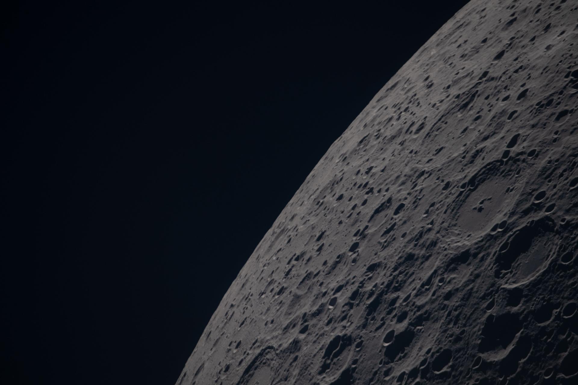
Poynting crater and Keeler crater are visible side by side in the lower right portion of this image of the Moon’s far side highlands. Poynting, positioned above, is a large impact crater with a well-defined rim and relatively smooth interior, indicative of material that has settled following the initial impact. Just below it, Keeler crater appears slightly smaller, with a sharply outlined rim and a more textured interior shaped by subsequent impacts and ejecta. Both features lie within the densely cratered far side highlands, preserving a record of ancient impacts that have shaped the lunar surface over billions of years.
NASA
The science from every Moon rock sample, lunar dataset, and discovery produced through NASA’s Artemis program will be shared by the agency with the global scientific community. That commitment is upheld by all 71 countries that have signed the Artemis Accords, a set of principles for safe and transparent civil space exploration.
NASA put those principles into practice by hosting a two-part virtual workshop series that began July 28 and concluded Sept. 8, focusing on one key tenet of the Artemis Accords: the timely release of scientific data to the public and the international scientific community.
“As we return humans to the Moon, our Artemis efforts will help us unlock the full potential of scientific discovery through transparency, collaboration, and accessibility,” said Jacob Bleacher, chief exploration scientist at NASA. “We are making data, tools, and results freely available, and inviting the Artemis Accords partners to innovate with us and share their data as well, accelerating our understanding of lunar processes and laying the groundwork for human space exploration for the Moon, Mars and beyond.”
The two recent workshops added to discussions led by the ISRO (Indian Space Research Organisation) in May, when signatories first explored ways to advance open data practices and created common ground for deeper conversations on open data. NASA split its follow‑on discussion about data sharing into two virtual sessions, so technical experts around the world could take part.
The agency hosted its first session on open science principles and implementation practices. It promoted interoperability and collaboration among signatories and advanced reproducibility, accessibility, and transparency in scientific work, including in NASA’s Artemis program.
The second session focused on tools for open science, providing Artemis Accords signatories with a working model to reference as they build or refine their own data-sharing frameworks.
“NASA is committed to leading by example when it comes to open science,” said Andrew Mitchell, deputy chief science data officer for NASA’s Science Mission Directorate, whose office leads the agency’s open science efforts. “These workshops gave our Artemis Accords partners practical tools and a shared foundation to build on as we move forward together.”
NASA presented the Planetary Data System, one of the agency’s primary archives for planetary science data, openly available lunar data, data visualization and analysis tools, and the system’s data information model standard, offering a real-world example of how NASA structures, curates, and shares scientific data with the world.
Across both sessions, NASA shared practices developed over years of stewarding scientific data and opened the floor to technical experts across the Artemis Accords community, reflecting a deliberate effort to build alignment at the working level.
“Advances in technology help enable open science, but technology alone is insufficient,” said Mitchell. “Open science requires a shift to a more transparent and collaborative scientific process, which will increase the pace and quality of scientific progress. Scientific processes and results should be as open and repeatable as possible to encourage further study.”
In 2020, NASA and the State Department joined with seven other founding nations to establish the Artemis Accords in response to the growing interest in lunar activities by both governments and private companies. They introduced the first set of practical principles aimed at enhancing the safety and coordination between like-minded nations as they explore the Moon, Mars, and beyond, committing nations to:
explore peaceably and transparently
render aid to those in need
enable access to scientific data
ensure activities do not interfere with those of others
preserve historically significant sites and artifacts by developing best practices
By signing the Artemis Accords, nations open the door to opportunities for future lunar exploration with NASA, advancing humanity’s return to the Moon, and shaping the Golden Age of space exploration and innovation.
Almost a hundred years ago, physicists theorized out what free fall should do to a quantum wave. If the solution they came up with is wrong, quantum mechanics and Einstein's theory of gravity flatly contradict each other. But testing it has been impossible because nobody has managed to build an interferometer that could perform the necessary measurement.
Now, a team led by Ron Folman, a physicist at Ben-Gurion University of the Negev, with collaborators in Germany, the UK, and the US, including Nobel laureate Roger Penrose, has done it. They built a new interferometer that gives a single atom two possible paths at once: one that involves a free fall, and another where it is held perfectly still. Both paths end at the same place at the same moment, allowing the team to measure what the fall does to a wave-like property of the atom.
Long time coming
Ever since Galileo, physicists have known how to describe a falling object—where it is, how fast it goes, or how quickly it accelerates. Quantum mechanics, though, insists that every object is also a wave. “Every particle, doesn't matter if it's a car or a spaceship or an atom, is a wave,” Folman says. “Everything that is a wave, like sea waves or sound waves, goes up and down. And if you're up or down, this is measured by something called a phase. A phase just tells you if you are at the top of the wave or at the bottom.”
The European Space Agency is moving "full steam ahead" with development of a robotic mission to Venus after NASA officials determined they were unlikely to fulfill a commitment to provide a US-built radar instrument for the spacecraft, the mission's project scientist said.
The European orbiter, named Envision, will map the Venusian surface at 10 times higher resolution than the last radar mission sent to Venus by NASA in the 1990s. The planet is enshrouded in a blanket of thick clouds of sulfuric acid, rendering its mysterious surface unseen by optical cameras in orbit. Radar is the most effective way to penetrate the clouds of Venus to reveal the terrain below, and scientists will use Envision to look for signs of active volcanism.
NASA and ESA signed a memorandum of understanding in 2024 outlining their partnership on Envision. NASA agreed to supply a US-made synthetic aperture radar instrument, Envision's primary means of mapping the surface of Venus, along with providing tracking and communications support through NASA's Deep Space Network. In exchange, ESA would include US researchers on Envision's science team. Europe would build the Envision spacecraft and the rest of its science instruments and provide the launch on an Ariane 6 rocket.
It turns out Jean-Luc Picard was an even better starship helmsman than the writers knew. A physicist has gone through the details of a warp-speed trick from the first season of Star Trek: The Next Generation and found a subtlety the show missed. But instead of a plot hole, the detail he found actually makes the maneuver more impressive… as well as a great opportunity to teach about a lesser-known feature of the theory of relativity.
Níckolas de Aguiar Alves, a physicist at the Federal University of ABC in Brazil, first watched Next Generation as a master’s student. When he got to the episode "The Battle" in the show’s first season, the plot reminded him of his relativity coursework.
In "The Battle," a Ferengi leader reminds Picard of a battle he fought years ago as captain of a ship called the Stargazer. Under fire from a mysterious attacker, Picard’s ship’s shields were down. He had to get closer without taking a hit, so he made a gamble. Picard ordered the Stargazer to charge the enemy ship at warp speed (meaning faster than light), then stop abruptly and fire. By going faster than light, Picard anticipated that the other ship would see two images of the Stargazer: where it reached warp speed and where it stopped. If they fired on the wrong image, they would miss the Stargazer, and Picard could win the battle.
Scientists have an indisputable playful side, evidenced by frequent allusions to popular culture in their research publications. That includes popular song lyrics. And the most popular musical group, in terms of how frequently their songs and lyrics appear in the scientific literature, is The Beatles, according to a new paper published in the journal PLoS ONE.
“Some of these are genuinely brilliant," said co-author Gabriel Budel of Delft University of Technology in the Netherlands of the more than 3,000 references they found to The Beatles. "'The lung and winding road' is a paper on Long COVID that changes one vowel. 'Here comes the SU(N)' turns 'Here Comes the Sun' into a quantum computing paper about mathematical groups. Someone was having a very good day at their desk.”
Back in 2014, scientists at the Karolinska Institute in Sweden revealed that they had been deliberately inserting Bob Dylan lyrics into their papers as part of a long-running bet, starting with a 1997 Nature review entitled "Nitric Oxide and inflammation: The answer is blowing in the wind." That resulted in a 2015 study on whether Dylan lyrics appeared elsewhere in the biomedical literature; the most frequently referenced were "The Times They Are A'Changin'" and "Blowing in the Wind."
 Login
Login


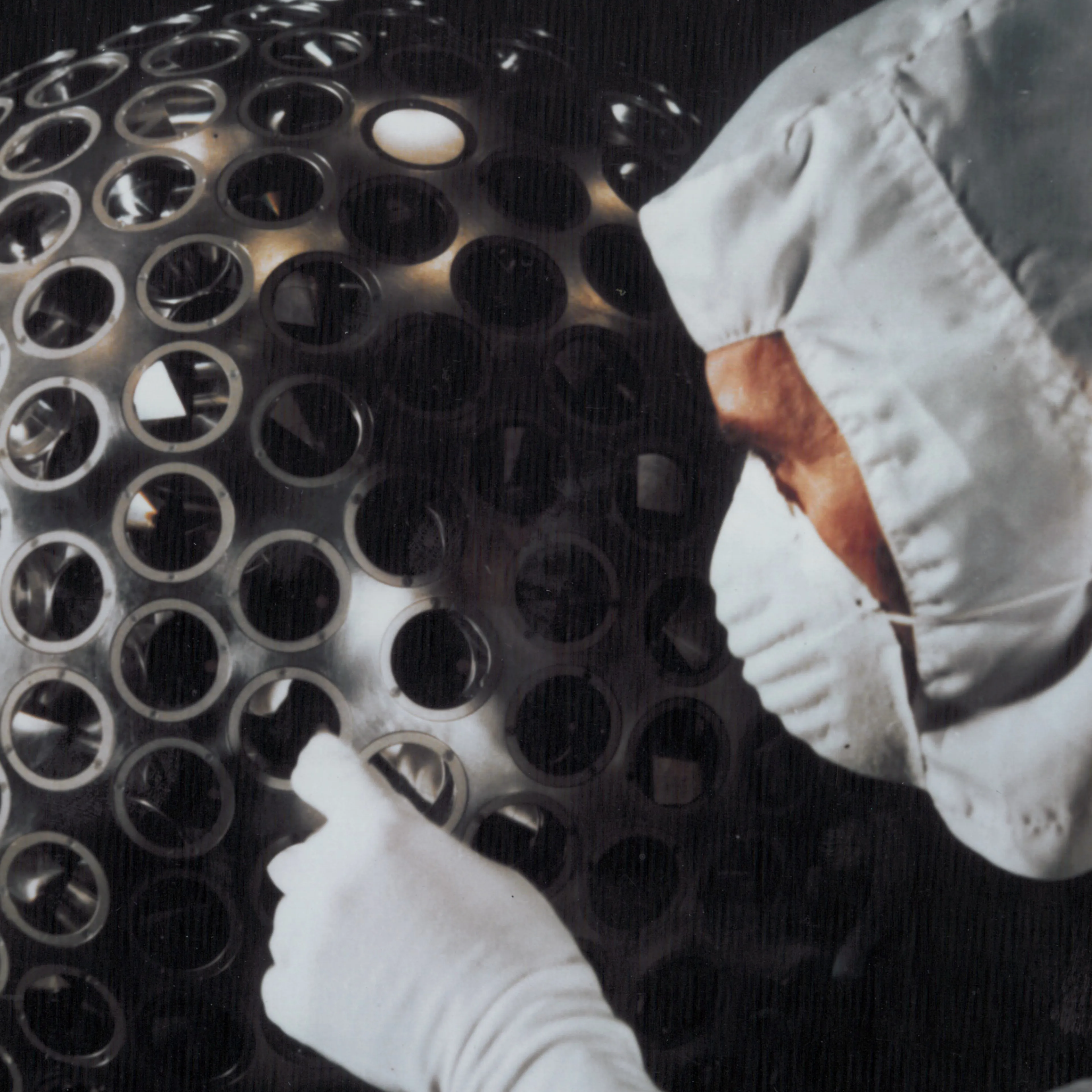 The lens-like objects covering the surface of LAGEOS-1 are corner cube retroreflectors, which have the nifty effect of always reflecting incident light right back towards its source.