Normal view

There are new articles available, click to refresh the page.
Before yesterdayMain stream

Monterrey Amid Mountains

11 September 2026 at 00:01
The light-colored urban development of Monterrey, Mexico, fills most of the top half of the photo, and green parallel mountain ridges arc across the bottom of the frame.
August 26, 2026

The curving, parallel mountain ridges of the Sierra Madre Oriental are an eye-catching feature of northeastern Mexico’s landscape. The spot where these folds nestle up against Mexico’s second-largest metropolitan area captured the attention of an astronaut aboard the International Space Station, who took this photo on August 26, 2026.

Monterrey, the capital of the state of Nuevo León, is an industrial hub supporting heavy industries such as ironworks and steelworks, as well as manufacturing facilities for goods ranging from textiles to processed foods to glass and plastics. The metropolitan area is home to 5.3 million people, according to the 2020 census. And while the city has seen overall population growth since 1990, the number of people living within 5 kilometers (3 miles) of the city center has declined, researchers have found—a trajectory shared with many of Mexico’s metropolitan areas.

In Monterrey’s case, urban expansion runs up against some unforgiving terrain. Along the city’s southern edge, layers of limestone, deposited in the late Mesozoic era and then folded between about 80 and 50 million years ago, form the Sierra Madre Oriental. Over millions of years, weaker rock layers have eroded away, leaving behind the distinct ridgelines that bound Monterrey today.

The Río Santa Catarina carves through the mountains and onto the semiarid floodplain where the city lies. Because of the dry environment, the river carries little to no water for much of the time. But its channel is crucial for collecting runoff from summer rains and serves as an important natural area for plant and animal life within the city.

The river runs through Monterrey’s urban core and between several island-like protrusions of folded rock. One of these is the Sierra Las Mitras, a state nature reserve established in 2000. The mountain ridge rises approximately 1,500 meters (4,900 feet) over the city and provides a haven for wildlife. As conditions become cooler and wetter with higher elevations, vegetation turns from cacti and thorny shrubs on lower rocky slopes to oak and pine forests higher on the ridge. Cerro de la Silla (Mount Silla or Saddle Hill) is another prominent feature of the landscape, contrasting with the built environment.

Near the city’s border with the Sierra Madre Oriental sits Universidad de Monterrey, a host venue for the NASA Space Apps Challenge. This annual hackathon will take place in November 2026 in person and virtually at sites around the world. Participating teams use NASA and partner agency data to tackle challenges in fields such as software development, astrophysics, space exploration, and agriculture.

Astronaut photograph ISS075-E-70481 was acquired on August 26, 2026, with a Nikon Z9 digital camera using a focal length of 400 millimeters. It is provided by the ISS Crew Earth Observations Facility and the Earth Science and Remote Sensing Unit at NASA Johnson Space Center. The image was taken by a member of the Expedition 75 crew. The image has been cropped and enhanced to improve contrast, and lens artifacts have been removed. The International Space Station Program supports the laboratory as part of the ISS National Lab to help astronauts take pictures of Earth that will be of the greatest value to scientists and the public, and to make those images freely available on the internet. Additional images taken by astronauts and cosmonauts can be viewed at the NASA/JSC Gateway to Astronaut Photography of Earth. Story by Lindsey Doermann.

Downloads

The light-colored urban development of Monterrey, Mexico, fills most of the top half of the photo, and green parallel mountain ridges arc across the bottom of the frame.

August 26, 2026

JPEG (14.83 MB)

References & Resources

You may also be interested in:

Stay up-to-date with the latest content from NASA as we explore the universe and discover more about our home planet.

Great Balls of Fire

4 min read

An astronaut on the International Space Station was surprised to photograph a shower of light streaking through the darkness while…

Article

The World Cup From 250 Miles Up

4 min read

Over the years, astronauts aboard the International Space Station have photographed several of the cities hosting the 2026 FIFA World…

Article

The Birthplace of the United States

3 min read

It was here the founders shaped the future of American government.

Article

The Otherworldly Geology of Vasquez Rocks

8 September 2026 at 00:01


false color
natural color

In this false-color image, areas with more extensive vegetation on the Sierra Pelona retain more moisture than the hills surrounding Agua Dulce, making the Sierra Pelona appear dark green in comparison to the rusty brown coloration of the lower hills. Vasquez Rocks appears as a patch of curved gray stripes near the center of the image.
NASA Earth Observatory/Michala Garrison

This natural-color image shows the same area, but there is less difference in colors between higher-elevation and lower-elevation vegetation. Most features in the image are shades of brown.
NASA Earth Observatory/Michala Garrison

In this false-color image, areas with more extensive vegetation on the Sierra Pelona retain more moisture than the hills surrounding Agua Dulce, making the Sierra Pelona appear dark green in comparison to the rusty brown coloration of the lower hills. Vasquez Rocks appears as a patch of curved gray stripes near the center of the image.
NASA Earth Observatory/Michala Garrison
This natural-color image shows the same area, but there is less difference in colors between higher-elevation and lower-elevation vegetation. Most features in the image are shades of brown.
NASA Earth Observatory/Michala Garrison

false color

natural color


A patchwork of chaparral and sage scrub vegetation shades the hills and mountain ranges surrounding Agua Dulce and Vasquez Rocks in this pair of images captured by the OLI (Operational Land Imager) aboard Landsat 9 on July 28, 2026. The false-color image (bands 6-5-4) on the left incorporates shortwave-infrared and near-infrared observations that accentuate differences in vegetation and soil moisture in comparison to the natural-color image on the right. NASA Earth Observatory images by Michala Garrison.

Editor’s Note: Today’s story is the answer to the September Puzzler.

Several of the outcrops at Vasquez Rocks Natural Area in Southern California jut from the arid landscape of the Soledad Basin at remarkable angles. Geologists estimate that the tilt of sedimentary rock strata found in the area averages 50 degrees, steep enough that many of the otherworldly formations appear to point toward the stars.  

That’s fitting, in some ways, because the rocks have served as one of the Star Trek franchise’s favorite backdrops ever since the show’s inaugural season, when Captain James T. Kirk scrambled up the jagged terrain during an iconic battle with a member of a reptilian alien species.

Viewed from space, the Vasquez Rocks are considerably less dramatic, but they show up clearly as bands of gray nestled between mountain ranges in these false-color (left) and natural-color (right) images captured by the OLI (Operational Land Imager) on Landsat 9. The false-color view (bands 6-5-4) incorporates shortwave-infrared and near-infrared observations that accentuate differences in the landscape’s vegetation in comparison to the natural-color image on the right.

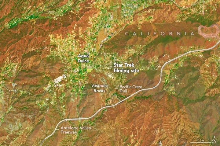
A zoomed-in view of the Vasquez Rocks part of the image highlights a sandy parking lot where Star Trek scenes were filmed, the Antelope Valley Freeway, and the nearby community of Agua Dulce.
Proximity to Los Angeles and the freeway is among the reasons the tilted strata at Vasquez Rocks have long been a popular filming location for television producers. This false-color image (bands 6-5-4) was captured by the OLI (Operational Land Imager) aboard Landsat 9 on July 28, 2026.
NASA Earth Observatory/Michala Garrison

The Vasquez Rocks didn’t start out pointing skyward. When they were forming 25 million years ago, sediment was spread across alluvial fans—cone-shaped deposits that develop as fast-moving streams empty onto relatively flat plains. The sediment likely hadn’t traveled far, much of it eroding from nearby uplands. Over time, the alluvial fan deposits were buried and cemented into thick layers of sandstone and conglomerate rock.

Over millions of years, the region was then reshaped by the interaction of tectonic plates just to the east. Two plates grind past each other along a boundary that includes the San Andreas Fault, a strike-slip fault where the North American plate moves southeast and the Pacific plate northwest, contributing to the powerful tectonic forces that ripple throughout the region.

Eventually this tectonic activity led to the uplift and deformation of the Soledad Basin, with sedimentary layers gradually tilting, folding, and rotating. Once they were exposed at the surface, millions more years of weathering and erosion sculpted the formations further, removing softer material and leaving the more resistant sandstone and conglomerate fins and ridges that wow visitors today.

The rock formations represent far-flung moons and planets in several other Star Trek episodes and Vulcan, Spock’s home planet, in two Star Trek movies. Other productions have highlighted the Vasquez Rocks as well. They make appearances in dozens of other television shows and movies, including the science fiction series Westworld, For All Mankind, and Battlestar Galactica.

NASA Earth Observatory images by Michala Garrison, using Landsat data from the U.S. Geological Survey. Story by Adam Voiland.

Downloads

In this false-color image, areas with more extensive vegetation on the Sierra Pelona retain more moisture than the hills surrounding Agua Dulce, making the Sierra Pelona appear dark green in comparison to the rusty brown coloration of the lower hills. Vasquez Rocks appears as a patch of curved gray stripes near the center of the image.

July 28, 2026: False color (bands 6-5-4)

JPEG (22.57 MB)

This natural-color image shows the same area, but there is less difference in colors between higher-elevation and lower-elevation vegetation. Most features in the image are shades of brown.

July 28, 2026: Natural color

JPEG (19.33 MB)

References & Resources

You may also be interested in:

Stay up-to-date with the latest content from NASA as we explore the universe and discover more about our home planet.

Digging Back in Time in the UAE

5 min read

Once below a shallow sea, Jabal al Fāyah now stands above the desert in the United Arab Emirates as a…

Article

What Lake Bonneville Left Behind

5 min read

The drying of the massive lake exposed playas that became the setting for feats of engineering and technological ingenuity, as…

Article

Pumice Rafts Encroach on Admiralty Islands

4 min read

Buoyant volcanic rock fragments from an underwater eruption drifted across the Bismarck Sea and choked island coasts.

Article

How the Tide Turns at the Mouth of the Elbe

6 August 2026 at 00:01


August 15, 2025
May 11, 2025

The Elbe river in Germany into the North Sea on the left side of the image. Low tide exposes wide, light-colored tidal flats interrupted by branching channels of dark water.
The ocean’s ebbs and flows reveal dynamic tidal flats and a well-traveled shipping route along the German coast.
NASA Earth Observatory/Lauren Dauphin

The Elbe river in Germany into the North Sea on the left side of the image. At high tide, a handful of small islands and crescent-shaped sandbars remain exposed above the water level near shore. Ships are visible as small, bright specks on the water.
The ocean’s ebbs and flows reveal dynamic tidal flats and a well-traveled shipping route along the German coast.
NASA Earth Observatory/Lauren Dauphin

The Elbe river in Germany into the North Sea on the left side of the image. Low tide exposes wide, light-colored tidal flats interrupted by branching channels of dark water.
The ocean’s ebbs and flows reveal dynamic tidal flats and a well-traveled shipping route along the German coast.
NASA Earth Observatory/Lauren Dauphin
The Elbe river in Germany into the North Sea on the left side of the image. At high tide, a handful of small islands and crescent-shaped sandbars remain exposed above the water level near shore. Ships are visible as small, bright specks on the water.
The ocean’s ebbs and flows reveal dynamic tidal flats and a well-traveled shipping route along the German coast.
NASA Earth Observatory/Lauren Dauphin

August 15, 2025

May 11, 2025


One of the major rivers of Europe, the Elbe flows more than 1,000 kilometers (600 miles) across the continent before reaching the North Sea. At its mouth, the low-lying landscape is continually reshaped by the rise and fall of the tides. These dynamic tidal flats are a boon to biodiversity while sometimes posing challenges for those navigating its waters and for communities living along its shores.

The images above illustrate how the area changes with the tides. They were acquired on August 15, 2025, at low tide (left) and on May 11, 2025, at high tide (right) with the OLI (Operational Land Imager) on Landsat 9. The mean tidal range at Cuxhaven is 2.9 meters (9.5 feet), which is considered intermediate, or mesotidal. The tides are also asymmetrical, meaning the flood period is shorter than the ebb. This causes the incoming current to run faster and typically carry more sediment up the 140-kilometer-long (87-mile-long) estuary than it does out.

The low tide exposes complex channels, sandbars, and mudflats around the river mouth. This wide zone of coastal wetlands is part of the Wadden Sea, which stretches from the Netherlands to southern Denmark and represents the largest continuous system of intertidal sand and mud flats in the world. Its habitats serve as important staging, molting, and wintering grounds for migratory birds, with more than 10 million passing through every year.

A channel cuts through these natural features near the river’s mouth, allowing ships to reach Cuxhaven and Hamburg—the third-largest container port in the European Union—farther upriver. Dredging is required to remove accumulated sediment in the channel, and some ships can only pass through when the tide is high enough. The Elbe’s mouth also provides access to the Kiel Canal, which connects the North Sea and Baltic Sea and is the world’s busiest human-made waterway navigable by seagoing ships. 

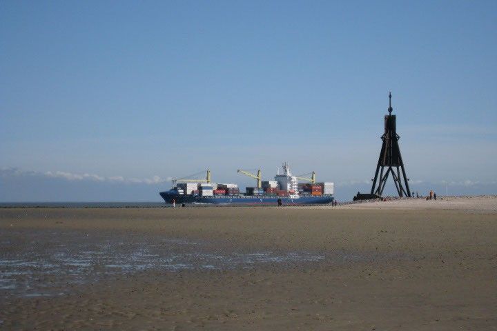
A broad tidal mudflat fills the foreground of this photo.  A sliver of deeper water is visible on the horizon, where a cargo ship loaded with shipping containers and cranes appears to be traveling to the left.
A cargo ship passes by mudflats at the mouth of the Elbe.
Thomas Gölles, April 5, 2009.

At high tide (right), only a handful of small islands and sandbars remain above the waves. One of these islands, Neuwerk, is a tranquil tourist destination that is home to a few dozen inhabitants and the oldest building on the German coast. A brick tower, completed in 1310 and later converted to a lighthouse, was built to protect shipping on the Elbe from pirates and wreckers.

These images show normal tidal variation in the area, but storms can push water levels much higher than a typical high tide. The highest water level measured at Cuxhaven—5.1 meters (16.7 feet) above Europe’s official sea level reference—occurred on January 3, 1976, when a fast-moving storm swept across the North Sea and slammed the coast with high winds. Researchers who reconstructed historical storms noted that the storm surge was worsened by its timing relative to the tide. The strongest winds arrived around low tide, preventing water that had propagated upstream at high tide from flowing back out to sea and causing further inundation inland.

Scientists study past extreme events like this to better understand how future storms might affect low-lying coastal areas and how flood protection could be improved. Flooding risks can be exacerbated by rising sea levels, which at Cuxhaven have trended upward by 2.12 millimeters per year, or 0.70 feet per century.

Two new Earth-observing satellites are making it possible to measure water levels in coastal areas in greater detail. The dual-band radar on the NISAR (NASA-ISRO Synthetic Aperture Radar) satellite is expected to track long-term phenomena such as sea level changes, as well as to map flood inundation and other ephemeral events. In addition, early data from NASA’s SWOT (Surface Water and Ocean Topography) satellite has demonstrated the potential to accurately measure water levels around complex coastlines and to improve tidal models.

NASA Earth Observatory images by Lauren Dauphin, using Landsat data from the U.S. Geological SurveyPhoto by Thomas Gölles. Story by Lindsey Doermann. 

Downloads

The Elbe river in Germany into the North Sea on the left side of the image. Low tide exposes wide, light-colored tidal flats interrupted by branching channels of dark water.

August 15, 2025

JPEG (6.33 MB)

The Elbe river in Germany into the North Sea on the left side of the image. At high tide, a handful of small islands and crescent-shaped sandbars remain exposed above the water level near shore. Ships are visible as small, bright specks on the water.

May 11, 2025

JPEG (6.02 MB)

References & Resources 

You may also be interested in:

Stay up-to-date with the latest content from NASA as we explore the universe and discover more about our home planet.

A Tide-Fueled Trove of Biodiversity in Guinea-Bissau

3 min read

The expansive mudflats, sandy beaches, and mangrove forests of the Bijagós archipelago support an array of migratory shorebirds and large…

Article

Signs of Thaw in the Bering Sea

3 min read

Drifting sea ice fragments near Alaska’s Saint Lawrence and Nunivak islands and colorful water around the Yukon Delta heralded the…

Article

Barents Sea Tied to Low Arctic Sea Ice

4 min read

Patches of open water in the region contributed to low sea ice extent across the Arctic in March 2026, which…

Article
❌
❌