Having watched some fun videos on repurposed satellite dishes on YouTube, [Melan] wanted to get in on the action, managed to source an Intellian i4 — a dish built for marine use — and set about hacking it.
[Melan] first needed to convince the antenna that it was still on a boat by using an RP2040 microcontroller and an RS-422 module to send NMEA sentences. This was necessary to tell the i4 the “heading” of the “boat”, even though [Melan] was really using the rig stationary on land. From there, a simple email to the company itself sufficed to get the Intellian software running on the antenna.
But could it be controlled without the software?. Sniff the communications between the software and the Antenna Control Unit, and decompile the code. This done, it was relatively straightforward to put together a protocol description and figure out how to command the antenna where to point simply by issuing commands for azimuth and elevation.
Two satellites from Russia’s Rassvet broadband constellation, the country’s answer to SpaceX’s Starlink, are expected to fall back into the atmosphere and burn up within the next day or two after failing to raise their orbits, Harvard-Smithsonian astrophysicist and satellite tracker Jonathan McDowell said, while most of the other Rassvet-3 satellites have now settled into […]
Sea levels are higher than normal across the central and eastern equatorial Pacific in October 2026 (right), a hallmark of El Niño. The pattern closely resembles October 1997 (left), during another one of the strongest El Niño events in the satellite altimetry record.
NASA Earth Observatory / Lauren Dauphin
october 13, 1997
october 12, 2026
October 13, 1997 – October 12, 2026
Sea levels are higher than normal across the central and eastern equatorial Pacific in October 2026 (right), a hallmark of El Niño. The pattern closely resembles October 1997 (left), during another one of the strongest El Niño events in the satellite altimetry record. Maps by NASA Earth Observatory/Lauren Dauphin using altimetry data provided by NASA/JPL-Caltech.
El Niño is part of a natural climate pattern that occurs roughly every two to seven years, bringing warmer-than-normal water to parts of the equatorial Pacific. The most recent very strongEl Niño events, in 1997-98 and 2015-16, upended weather patterns. Impacts spanned the planet, from fires in Indonesia and the Amazon, to crop failures due to drought in southern Africa, to heavy rain and coastal flooding in Southern California. The current El Niño rivals these past heavyweights.
Every El Niño grows from a feedback loop between the atmosphere and the ocean. Trade winds normally keep warm water piled up in the western Pacific, where it stands higher than in the east. When those winds weaken, that warm water begins to pulse eastward, which further weakens and sometimes reverses the winds, allowing even more warm water to move east. The cycle intensifies as waters continue to warm and pile up in the central and eastern Pacific.
But each El Niño has its own character, shaped by where in the Pacific the warmth builds and how the atmosphere responds. “The search for the ‘typical’ El Niño is very elusive,” said Josh Willis, project scientist for sea level missions at NASA’s Jet Propulsion Laboratory (JPL). “They’re all different in terms of where they land and how their impacts play out.”
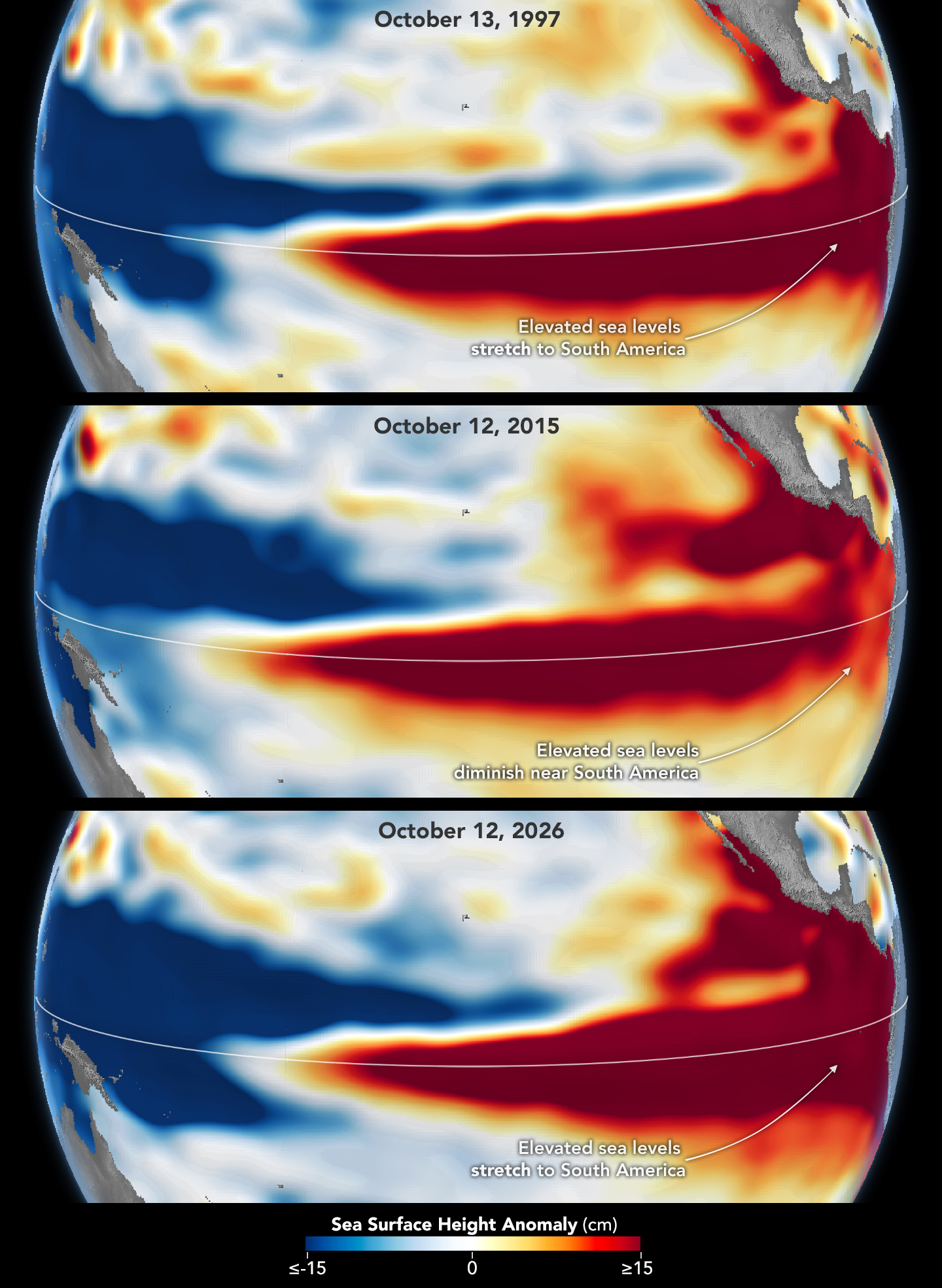
Altimetry satellites can track those differences by measuring the height of the sea surface. Because water expands as it warms, higher-than-normal sea levels in the central and eastern equatorial Pacific signal the buildup of heat associated with El Niño. The maps above depict sea surface height anomalies across the Pacific Ocean on October 13, 1997 (left), and on October 12, 2026 (right). Data are from the TOPEX/Poseidon satellite and the Sentinel-6 Michael Freilich satellite, respectively, and were processed by scientists at JPL.
Shades of red indicate where sea levels were higher than average. Normal sea level conditions appear white, and lower areas are blue. Signals related to seasonal cycles and long-term trends have been removed to highlight sea level anomalies associated with El Niño and other short-term natural phenomena.
“What’s unique about altimetry is that we have a 35-year record from nearly identical satellites flying almost the same ground track, with each mission overlapping the next,” Willis said. “That lets us look back in time and compare this El Niño to what happened in 1997. And right now, this one is on track to be even bigger.”
Compared with the 1997-98 event, El Niño in 2026 came on much more suddenly. But as of October, the two events appear similar in character—the tilt of sea level (low in the west and high in the east) and high, warm water extending all the way to South America—so Willis thinks the impacts could be similar as well. In 1997-98, that meant, for instance, lots of rain in California and across the southern tier of the U.S.
The 2015-16 El Niño was also very strong, as elevated sea levels in October 2015 (middle) show. But its pattern differed from those in October 1997 (top) and October 2026 (bottom): less of the elevated water reached the coast of South America, which contributed to different weather patterns that year.
The 2015-16 El Niño was another heavy hitter but differed in its character. Sea surface height anomalies on October 12, 2015, based on altimetry data from the Jason-2 satellite, are shown above in context with maps from around the same time in 1997 and 2026. In 2015, the exceptionally warm, high water along the equator didn’t push up against South America to the extent it did in the other years. Rainfall impacts that winter concentrated more over Central America and the southeastern U.S., with significant flooding in Mexico.
NOAA’s El Niño outlook on October 8, 2026, called for an 83 percent chance of a strong-to-very strong El Niño through the first three months of 2027. But exactly how the impacts will play out in winter 2026-27 and beyond remains to be seen. Willis noted that El Niño’s influence propagates through a chaotic atmosphere, and the signal can get muddled as it extends beyond the tropics. “There’s always a bit of a dice roll here,” Willis said. “Just because this El Niño looks like 1997 doesn’t mean it will be exactly the same—it’s just our best guess at the moment.”
NASA Earth Observatory maps by Lauren Dauphin, using NASA-SSH altimetry data provided by Josh Willis, Severine Fournier, and Kevin Marlis, NASA/JPL-Caltech. Story by Kathryn Hansen.
Portal Space Systems’ Starburst-1 spacecraft is shown in orbit aboard a SpaceX Falcon 9 rocket prior to deployment. (SpaceX Webcast Image)
Portal Space Systems has reached Earth orbit for the second time this year, successfully launching the startup’s first free-flying spacecraft, Starburst-1, aboard a SpaceX Falcon 9 rocket.
Portal’s Starburst-1 lifted off Tuesday at 7:04 a.m. EDT from Space Launch Complex 40 at Cape Canaveral Space Force Station. The spacecraft separated from SpaceX’s Falcon 9 on the Bandwagon-5 rideshare mission about 57 minutes later.
Within hours of deployment, the Bothell, Wash.-based company reported that the desk-sized craft had established ground communications, stabilized itself, and successfully deployed its solar array to become power positive.
It marks the second significant milestone for Portal this year, following the March debut of Mini-Nova — a tissue-box-sized technology demonstration payload that flew on a SpaceX Falcon 9 mission to test critical control and power systems in orbit.
SpaceX’s Bandwagon-5 mission lifts off from Cape Canaveral, Fla., carrying Portal Space Systems’ Starburst-1 satellite. (SpaceX Webcast Image)
Portal self-funded Starburst-1 to accelerate its flight timeline and prove out hardware for prospective customers, achieving orbit in less than a year since introducing the Starburst vehicle concept in November 2025.
Co-founder and CEO Jeff Thornburg emphasized that urgency is baked into the startup’s operational philosophy, noting that customers require spacecraft that can shift rapidly in orbit.
“Speed can’t just be part of the product. It has to be part of the company building it,” Thornburg said in a statement. “Our customers need spacecraft that move quickly in orbit and a company that moves with the same urgency to get them there. We put our own capital behind Starburst-1 because proving hardware in flight is how we earn their confidence.”
Thornburg shared video of the launch and deployment of Starburst-1 on LinkedIn.
Starburst is an ESPA-class spacecraft designed to execute rapid maneuvers within a specific orbital regime, giving commercial and defense operators greater operational flexibility. The vehicle shares the majority of its core systems and manufacturing processes with Supernova, Portal’s larger upcoming spacecraft built for rapid travel across different orbital regimes, with flight data from Starburst-1 directly informing both platforms.
Portal Space Systems co-founders Jeff Thornburg, left, the startup’s CEO, and Prashaanth Ravindran, VP of engineering, call fellow co-founder Ian Vorbach from Kennedy Space Center immediately after the launch of Starburst-1. (Portal Space Systems Photo)
Starburst-1 is carrying experimental technologies from three partner companies to test in orbit:
Zenno Astronautics’ Supertorquer: A superconducting magnetic attitude-control system designed to orient the spacecraft using Earth’s magnetic field — conserving onboard propellant — while testing whether its magnetic field can shield sensitive electronics from radiation.
TRL11’s Fovea M1: A specialized camera system providing live video of Starburst-1 and its surroundings, including visual confirmation of the solar array deployment.
Atomic-6’s Space Armor: Protective tiles engineered to shield the spacecraft from high-speed orbital debris without creating additional secondary debris.
Since emerging from stealth in 2024, Portal has raised $75 million in funding — including a $50 million round in April — from investors including Geodesic Capital, Mach33, Booz Allen Ventures, AlleyCorp, and FUSE, alongside receiving critical SBIR and STRATFI support from the U.S. military.
GeekWire got an inside look at Portal’s 8,000-square-foot Bothell development and testing lab earlier this year. To prepare for future demand — including a dedicated 2028 Falcon 9 mission known as Motus Via Sol that will carry multiple Starburst spacecraft and the first Supernova — Portal has been expanding its footprint.
The company — No. 107 on the GeekWire 200 index of top-ranked Pacific Northwest startups — is in the process of transitioning its satellite manufacturing operations into a new 65,000-square-foot facility in Bothell, which is slated to be fully operational by next year and capable of producing up to 16 Starburst and 12 Supernova spacecraft annually.
When most radio enthusiasts start trying to pick up signals from satellites, they might put together a quick-and-dirty Yagi antenna and try to catch a repeater as is passes overhead, or they might grab a small unused dish from a satellite TV service and point it up at a weather satellite by hand to try to decode some of the data coming down. But [Cranktown City] had a different approach. He found an eight-foot dish online and built a massive articulating base station out of it as his first exploration into the world of satellites.
The first problem that needs to be solved with a dish of this size is its mounting location. This installation uses a large post and concrete foundation with a custom-fabricated metal base at the bottom. The metal base houses all of the electronics not just for receiving signals from the dish, but also for orienting it properly. That includes a large metal gear driven by a wheelchair motor to control its azimuth and a linear actuator to take care of its elevation. Getting the large dish onto the frame was its own ordeal, complicated by the fact that it’s not uniform in its shape and has to be mounted in a specific orientation.
With everything assembled, the circularly-polarized antenna installed, and the computers up and running, the dish is able to track satellites across the sky and download data from things like GOES weather satellites. [Cranktown City] also built in a system that detects wind and points the dish vertically when it goes above a certain speed. This level of effort is impressive, and absolutely not required to listen in on plenty of sattelite activity out in the sky, but this installation will certainly give [Cranktown City] a lot of mileage and possibly even work for some radio astronomy.
This visualization compares three ocean data products, sea surface temperature anomaly, apparent visible wavelength, and sea surface height anomaly, over the same months in 2025 and 2026. Signals of El Niño in each map are highlighted with pop-up labels.
Credits: NASA’s Scientific Visualization Studio
A phenomenon rarer than a solar eclipse and more powerful than any single storm system is unfolding this fall, and NASA is tracking it closely.
El Niño is a natural climate pattern that emerges roughly every two to seven years marked by warmer-than-normal water temperatures in parts of the equatorial Pacific. NASA scientists are keeping watch as it flips trade winds, redistributes ocean heat, scrambles rain patterns, and raises sea surface height across parts of the Pacific.
As of October, the National Oceanic and Atmospheric Administration (NOAA) has said that there’s an 83% chance that the strongest El Niño since 1950 is currently unfolding. People around the world, including farmers, firefighters, and coastal communities, are already experiencing the effects in different ways.
Follow along with these maps as NASA tracks El Niño from its epicenter in the equatorial Pacific Ocean.
Sea surface height in flux
Lower-than-normal sea level conditions appear blue, and higher areas are orange and red in this map, which compares the ocean in 2025 (a weak La Niña year) and 2026. The map was created using altimetry data from the Sentinel-6 satellites, which measure water height for the entire ocean every 10 days, down to fractions of an inch.
Credit: NASA’s Scientific Visualization Studio
One of the first clues appeared in satellite imagery in January 2026, when a swell of warm water called a Kelvin wave was spotted near Micronesia in the western Pacific. Kelvin waves are slow-moving pulses of water thousands of miles long. Like underwater freeways, they transfer heat from west to east across the Pacific. The warm water heats the air directly above it, making it rise. The change in air pressures weakens or even reverses the trade winds that typically blow in the opposing direction, from the Americas toward Asia, causing sea levels in the eastern Pacific to rise further, and waters to warm even more. This chain reaction signifies the start of an El Niño.
The map above shows that by early April, those Kelvin waves had reached the eastern Pacific, and sea surface temperatures had begun to warm. Warm water expands in volume, elevating local sea levels in some areas by as much as 1 to 1.3 feet (30 to 40 centimeters). The higher-than-normal water can be seen sloshing toward South America then moving up the coast to California. Sea levels that are six to eight inches (15 to 20 centimeters) lower than normal are visible around Indonesia and northern Australia.
“Kelvin waves are like the heartbeat of El Niño,” said Josh Willis, project scientist for sea level missions at NASA’s Jet Propulsion Laboratory in Southern California. “And our sea level satellites let us peer into the ocean and watch every beat.”
Scientists have used satellite altimetry to track the height of the ocean with ultraprecision since 1993. That unbroken data record continues today with the Sentinel-6 satellites. State-of-the-art radar altimeters aboard these satellites survey millions of square miles of ocean in a single day, complementing NOAA’s fleet of ocean sensors and buoys drifting and diving through the water below.
Warming Pacific waters
The map above compares sea surface temperatures in 2025 (a weak La Niña year) and 2026. Data are acquired from satellite instruments, buoys, and ship sensors.
Credit: NASA’s Scientific Visualization Studio
Warmer-than-normal seawater is one of the best-known indicators of El Niño. Already, sea surface temperatures in the eastern Pacific are about 3 degrees Fahrenheit (1.7 degrees Celsius) warmer than the long-term average and could jump another fraction of a degree in the coming months, Willis said.
Satellites carrying microwave and infrared radiometers can see through and around clouds to measure heat energy at the sea surface. Satellites in 2026 mapped the band of warmer-than-normal water as it expanded throughout the spring. The band, seen in dark red, stretches for millions of square miles from the heart of the Pacific to the coast of South America. Ocean temperatures can influence weather patterns around the world. Air above the water’s surface carries heat and moisture into the atmosphere, seeding rainstorms and rearranging weather patterns across the globe.
Ocean gets bluer
The map above compares Apparent Visible Wavelength from 2025 (a weak La Niña year) and 2026. Apparent Visible Wavelength is a data product from NASA’s PACE satellite utilizing ocean color data from the Ocean Color Instrument.
Credit: NASA’s Scientific Visualization Studio
El Niño’s warm waters also change the color of the ocean. A NASA satellite is tracking these subtle shifts in hues, as equatorial Pacific waters have become measurably more blue over the last several months.
“Some people think of water as being just blue, but it’s amazing the multitude of colors the ocean can be,” said Matthew Kehrli, a lead research scientist for the PACE (Plankton, Aerosol, Cloud, ocean Ecosystem) satellite team at NASA’s Goddard Space Flight Center in Greenbelt, Maryland.
This spectrum is in part thanks to microscopic plants called phytoplankton, which form the basis of the marine food web. There are thousands of different species of phytoplankton, which come in shades like teal, brown, or green. This year, in areas of the Pacific Ocean along the equator that are typically lush with phytoplankton and greener as a result, these hues are waning.
This is an expected effect of El Niño. Phytoplankton thrive in cool, nutrient-rich waters, but during an El Niño, the weakening trade winds reduce the upwelling of nutrient-rich deep water to the ocean surface. With limited food supply, phytoplankton abundance drops. This decline can trigger cascading effects across the marine food web, forcing other marine life to relocate to new feeding grounds.
This year’s El Niño is the first since PACE launched in 2024, providing new views of the phenomenon. The Ocean Color Instrument aboard PACE observes the ocean in hyperspectral color — across several hundred different wavelengths of visible, near-infrared, and ultraviolet light — monitoring phytoplankton and other ocean-color changes in near-real time. With PACE data, researchers calculate the average color of the ocean, simplifying spectra of light into a single number, known as apparent visible wavelength.
The 2026 map above shows the green area along the equator in the western Pacific Ocean shrink as a bluer shade fills in, indicating fewer phytoplankton. In contrast, the map from 2025 shows how the green-hued section stays steady over time.
“You have expectations of what you would think would happen,” Kehrli said. “But to visually see the results with the data products that you’re working with in real time is gratifying.”
NASA scientists will continue to monitor the signs and impacts of this El Niño with its fleet of Earth-observing satellites.
“El Niño touches almost all of us in some way every time it occurs,” Willis said. “While many have seen what it can do, we look to the ocean to understand why.”
SpaceX’s Falcon 9 rocket rises from its California launch pad, sending 130 payloads into orbit. (Credit: SpaceX via X)
Starfish Space’s first full-scale Otter satellite servicing vehicle went into orbit today, marking a major milestone for the Tukwila, Wash.-based startup.
The Otter spacecraft was among 130 payloads launched from Vandenberg Space Force Base in California aboard a SpaceX Falcon 9 rocket. Otter is roughly the size of a kitchen oven, with solar arrays that were folded up for launch.
Other payloads on the satellite rideshare mission, known as Transporter-18, included Cowboy Space’s first power-beaming satellite, a prototype for Google’s AI data-center constellation, and a NASA-funded probe that will track the energy released by galaxies and supernovas.
Today’s liftoff through surface-level fog — and the return of the Falcon 9’s first-stage booster to a nearby landing pad — proceeded like clockwork. A little more than an hour after launch, Otter separated from the rocket’s upper stage and powered up for orbital operations.
Once Otter is fully commissioned, it will rendezvous with and inspect a series of inoperable satellites for a $15 million NASA mission known as Small Spacecraft Propulsion and Inspection Capability, or SSPICY for short. The capabilities demonstrated by SSPICY could be used during future missions to check the health of active satellites, or dispose of defunct satellites.
SSPICY may not be the only mission that Otter takes on during its operating lifetime.
“Success in the mission is to actually go and provide this commercial inspection service on a number of these different spacecraft, and that will be a huge win in and of itself,” Starfish co-founder Trevor Bennett told GeekWire last week. “But we’re also bringing Otter along to provide servicing well beyond that, so we could go and inspect more spacecraft, or potentially do some additional docking past the initial mission.”
This inaugural Otter mission follows up on two orbital flight tests involving smaller-scale Otter Pup prototypes. The first test fell short of linking up with its target satellite but was able to demonstrate Starfish’s satellite-tracking system. The second Otter Pup went into orbit last year and is currently closing in on its target.
The blue circle highlights the placement of Starfish Space’s Otter spacecraft inside the Falcon 9 rocket’s upper stage prior to launch. (Credit: Starfish Space / SpaceX)
Google’s Project Suncatcher M1 prototype, built by Planet Labs, will test the tensor processing units that Google plans to use for its orbital AI data-center constellation. The prototype is “designed to gather in-orbit data on how our TPUs handle the physical stress of spaceflight and the radiation and thermal extremes of space,” Google said in a blog post.
Star Catcher’s Protostar satellite will be involved in an experiment to beam power from the main spacecraft to a smaller deployable satellite equipped with off-the-shelf solar panels. The Protostar mission is meant to blaze a trail for the orbital power grid that Star Catcher hopes to create.
The SPRITE CubeSat is part of a $4 million mission funded by NASA and led by the University of Colorado that will study how stars and galaxies shaped the evolution of the early universe. The satellite is equipped with a far-ultraviolet imaging spectrograph. SPRITE stands for Supernova Remnants and Proxies for Reionization Testbed Experiment.
An artist’s conception shows Starfish Space’s Otter spacecraft in orbit. (Starfish Space Illustration)
Tukwila, Wash.-based Starfish Space is ready for the first launch of its full-size Otter space servicing vehicle, following two orbital tests of scaled-down prototypes.
Otter is due to lift off from California’s Vandenberg Space Force Base no earlier than Oct. 1, riding into orbit alongside other payloads on SpaceX’s Transporter-18 satellite rideshare mission. The 660-pound (300-kilogram) spacecraft, roughly the size of a kitchen oven (plus solar arrays), will demonstrate technologies for inspecting inoperable satellites during NASA’s $15 million Small Spacecraft Propulsion and Inspection Capability mission (SSPICY).
“This is the moment Otter becomes real,” Starfish co-founder Austin Link said today in a news release. “It’s no longer something we’re designing for the future. The first Otter is built, it has a customer and a mission, and it’s going to space.”
After it separates from its SpaceX Falcon 9 rocket and undergoes commissioning, the spacecraft will maneuver to approach and observe multiple satellites up close.
“We have a series of candidates that we can go to,” Starfish’s other co-founder, Trevor Bennett, told GeekWire. “We’ve actually studied a number of these satellites as potential candidates, and those will be selected once we’re in orbit. … These are spacecraft that are in family with satellites that NASA would be interested in servicing, and by being decommissioned satellites, there is no concern about trying to maintain the operational mission while we do our mission.”
Insights gained during the SSPICY mission will be applied to future missions that would involve docking with other satellites. Otter is built to service satellites for extended operations, or to dispose of them if they’re no longer operable.
“Success in the mission is to actually go and provide this commercial inspection service on a number of these different spacecraft, and that will be a huge win in and of itself,” Bennett said. “But we’re also bringing Otter along to provide servicing well beyond that, so we could go and inspect more spacecraft, or potentially do some additional docking past the initial mission.”
Bennett said the satellites on the list range in size from hundreds of kilograms to multiple tons.
“What’s really interesting about some of these spacecraft is that they have not been seen in a long time,” he said. “And so there is not only value in doing the commercial mission that we set out to do, but we provide some of that data back to NASA and say, ‘This is how your spacecraft have held up over the years in orbit’ — which is an interesting learning for them as well.”
How long will the SSPICY mission last? Bennett said that’s an open question. “Depending on how long each inspection takes, and how long the transit is to subsequent spacecraft, it’s probably a couple of years that we would be operating around multiple clients with this mission,” he said. “There’s always an opportunity for an extended mission here.”
The Otter spacecraft is maneuvered into position in a clean-room setting. (Starfish Space Photo)Workers carefully position the Otter spacecraft in their workshop. (Starfish Space Photo)Starfish Space’s first Otter spacecraft sits on a platform with its solar arrays folded during preparations for launch. (Starfish Space Photo)
This won’t be the first Starfish spacecraft to go into orbit. The startup, which Bennett and Link founded in 2019 after working at Jeff Bezos’ Blue Origin space venture, launched an Otter Pup prototype that was about the size of a microwave oven in 2023. Although technical difficulties prevented the spacecraft from docking with its target satellite, it successfully demonstrated Starfish’s satellite-tracking system.
A second Otter Pup was launched last year and is currently closing in on a different target satellite. “We have been in the vicinity with it since about June, and we’re consistently flying quite close to that spacecraft with the intention of Otter Pup 2 actually being a docking mission,” Bennett said.
That means Starfish is working on at least six Otters, including the unit due for launch in October. “Now it’s all about how many Otters can we build, and how quickly can we get them up there for folks, because the demand is there,” Bennett said.
He said it currently takes about a year and a half for each Otter to go through the entire manufacturing process. “Part of our goal is to speed that process up and build toward a fleet strategy,” Bennett said.
Expanding the workforce is central to that goal. Just a few months ago, Starfish Space reported having more than 90 employees. “We’ve grown to over 120 people now, which is pretty large for where we have been over time, but it’s still a really focused team,” Bennett said.
To celebrate Otter’s upcoming debut, Starfish Space put on a party for its employees and for invited guests at the Seattle Aquarium on Wednesday night. The spacecraft itself couldn’t be there, because it’s already in California awaiting launch. But an Otter mockup was on display at the party — and nearby, the Seattle Great Wheel was illuminated in Starfish’s corporate shades of coral and azure.
“This is a big deal for Seattle,” Bennett said. “Anytime a Seattle space company is able to make a meaningful difference in the larger space ecosystem, that’s worth celebrating. If we can splash other companies’ colors on there when they have their great moments, why not make that a tradition going forward? We’re happy to be the first, and hopefully not the last, that gets to splash colors on a Ferris wheel and show off what the Seattle space community has to offer.”
Check out these snapshots from Wednesday night’s celebration:
Starfish Space co-founder Austin Link shows off a replica of the Otter servicing spacecraft. (GeekWire Photo / Alan Boyle)A crowd gathers around Starfish Space’s Austin Link to get a closer look at the Otter replica. (Starfish Space Photo)Starfish Space co-founder Trevor Bennett talks about the future of the Otter space program. (GeekWire Photo / Alan Boyle)Hans Koenigsmann, a veteran of SpaceX who now serves on the board of Kent, Wash.-based Stoke Space and serves as an adviser to other space companies, talks about the early days of SpaceX at Starfish Space’s celebration at the Seattle Aquarium. The launch of a SpaceX Falcon 1 rocket is shown on the screen behind him. (GeekWire Photo / Alan Boyle) Seattle’s Great Wheel is lit up in Starfish Space’s corporate colors, coral and azure, during the space company’s celebration at the Seattle Aquarium. (Starfish Space Photo)
An artist’s conception shows Gravitics’ Diamondback orbital carrier, which is due to make its debut as early as 2027. (Gravitics Illustration)
Marysville, Wash.-based Gravitics, which is developing orbital carriers for government and commercial customers, is getting ready for a reverse takeover that could lead to a $125 million public offering.
The two ventures have been discussing the deal for months. The terms for the public offering were announced last month, and this week, a notice filed with the Securities and Exchange Commission revealed a previously unreported $17 million funding round that was completed earlier this year. The filing appears to be part of the preparations for the reverse takeover.
Similar to a SPAC merger, a reverse takeover offers a faster route for a private company to go public by acquiring a less active shell company and taking control of the combined operations. Non-Invasive Monitoring Systems is a prime example: It stopped manufacturing motorized therapeutic platforms in 2019 but retained its OTC listing. The plan envisions “uplisting” the merged company from OTC to Nasdaq.
The reverse takeover strategy has been used by several prominent companies, including Berkshire Hathaway, Burger King and Bellevue, Wash.-based T-Mobile US. Gravitics plans to follow up on the merger with an offering of 8.1 million shares priced between $14 and $17, which averages out to $125 million.
Because the offering has been registered with the SEC, the parties to the transaction are in a quiet period that restrains them from commenting on the arrangements.
Gravitics was founded in 2021 by CEO Colin Doughan, chief architect Gary Hudson and chief marketing officer Michael DeRosa. Over the past five years, it has secured some high-profile contracts for the design and manufacture of orbital carriers and space station modules.
Although Gravitics hasn’t yet put any spacecraft in orbit, several projects are underway. In 2024, the company won a $125 million contract from Axiom Space to provide a pressurized module for Axiom’s yet-to-be-launched space station. Last month, NASA said it would issue an award of up to $225,000 to support Gravitics’ work on a hangar facility for orbital cargo vehicles.
An artist’s conception shows several Sophia Space satellites in orbit. (Sophia Space Illustration)
Sophia Space and SLI, an aerospace leasing venture based in Washington, D.C., say they’ve agreed on a $300 million asset-financing framework that will support the creation of a 10-satellite constellation for high-performance computing.
The details of the arrangement are as notable as the bottom line: Sophia Space will build the satellites, leveraging the startup’s patented TILE technology for modular in-space data processing. SLI will purchase the satellites under the terms of a financing agreement.
“SLI as the lessor will purchase the satellites from Sophia, hold title to the assets, and lease them to the end user on a long-term basis in exchange for fixed monthly or quarterly payments,” Max Yergan, the company’s senior vice president for investments, explained in an email. “Full control and operational responsibility for the assets sit with Sophia and the end user, who will determine between them how operations are handled.”
Sophia’s satellites are designed to deliver on-orbit edge data services for a wide variety of applications. “The demand we are underwriting exists today,” Yergan said. “Earth observation, weather and supply-chain analytics, disaster response and defense ISR [intelligence, surveillance and reconnaissance] users all face the same constraint now: They collect far more data than they can bring to the ground, and its value decays while it waits to be downlinked. Processing on orbit addresses that directly.”
The constellation’s first launch is targeted for as early as 2028. SLI would pay out funds linked to development and launch milestones, all the way through verification that the on-orbit network performs to pre-agreed standards.
The arrangement is laid out in a non-binding letter of support. “The non-binding nature is a reflection of where we are in the process, and is typical of large asset financings,” Yergan explained. “It sets the commercial framework so both parties can commit resources while definitive documentation is negotiated.”
Leasing arrangements are often seen in aviation and the maritime industry, but this is a relatively new concept for satellite ventures.
“This is the first time that this approach has been applied to this kind of constellation, but not the first time for in-space assets,” said Gareth Zundel, SLI’s senior vice president for communications. “In December 2025 we announced the acquisition of two AscendArc satellites that will be offered to operators on leasing terms. Then, in March this year, we did a similar deal with ReOrbit. We do believe, however, that we are the first leasing company to specialize in the space sector.”
Rob DeMillo, Sophia Space’s CEO and co-founder, said the arrangement demonstrates how far the commercial space industry has come.
“Asset financing didn’t invent aviation or shipping, but it accelerated them at scale,” he said in a news release. “We’re doing the same for orbital computing. This approach with SLI signals that Sophia Space’s space infrastructure is mature enough to attract the capital structures that have historically built terrestrial infrastructure.”
The approach also gives Sophia Space — which is headquartered in Pasadena, Calif., but also has strong ties to the Seattle area — access to capital without diluting the equity held by current investors, including Unlock Venture Partners in Seattle.
“Sophia has the technology, the team and the vision. What had been missing was access to scalable, non-dilutive capital,” said Praveen Vetrivel, SLI’s CEO. “This framework provides it, giving them the capacity and flexibility they need to build the next layer of digital infrastructure.”
Each of the 10 satellites in the constellation will link together six of Sophia’s TILE (Thermal Integrated LEO Edge) modules, with four Nvidia Jetson processors on each module. That adds up to 240 edge computing servers in orbit.
“These 10 spacecraft are dedicated to this transaction,” Yergan said. “Sophia’s other programs and partnerships involve separate spacecraft and separate funding and are not directly affected by this facility.”
Sophia Space has previously said that it plans to start selling TILE systems and related components to customers in 2028. The company is also collaborating with Axiom Space, Armada and Kepler Communications on separate in-space computing initiatives.
In June, Sophia Space announced the conclusion of a $7 million financing round that brought the company’s total funding to $22 million. That round took advantage of an arrangement known as a Simple Agreement for Future Equity, or SAFE, in which investors provide cash to a startup in exchange for the right to receive stock later.

 Login