❌

Normal view

There are new articles available, click to refresh the page.
Yesterday — 28 October 2026NASA Breaking News

NASA Selects 19 New Citizen Science Proposals in 2026

28 October 2026 at 12:25

So far, 2026 has seen a flood of successes for volunteers who do NASA science, exemplifying NASA’s commitment to gold-standard science—transparent, reproducible and intrinsically collaborative. The Backyard Worlds: Planet 9 project announced that their project volunteers have now discovered most of the known brown dwarfs, celestial objects that are similar to planets. The Zooniverse platform, with grant from NASA, reached a milestone of 1 billion classifications. Several projects have come online that leverage new super intelligence (SI) techniques to amplify or extend the work of volunteers. More NASA volunteers are using SI to build their own data tools and help write scientific papers than ever before.

Even with all of those achievements, our science community is already working on the next round of new volunteer projects and innovations. NASA’s Science Mission Directorate has selected nineteen proposals from research teams in 2026 that will result in new opportunities for you to do NASA science.

The Citizen Science Seed Funding Program

The Citizen Science Seed Funding Program (CSSFP-25) of NASA’s Science Mission Directorate aims to support scientists and other experts to develop citizen science projects and expand the pool of professional scientists who use citizen science techniques in their science investigations. Twelve new proposals to this program were selected.

Astrophysics

“The Rogue Worlds Project: Activating volunteers to uncover the hidden population of super Jupiters with SPHEREx” led by Principal Investigator Jacqueline Faherty from the American Museum of Natural History. This project will invite you to search data from NASA’s SPHEREx (Spectro-Photometer for the History of the Universe, Epoch of Reionization and Ices Explorer) mission to find free-floating planets and brown dwarfs in clusters of young stars. The SPHEREx space observatory mapping the entire sky in near-infrared wavelengths.

“Quantifying the calibrations between intrinsic galaxy merger timescales with visual pair/tidal-feature classifications” led by Principal Investigator Kameswara Bharadwaj Mantha of the University of Missouri. This project will investigate galaxy mergers, helping astronomers understand how galaxies evolve through time. You will be invited to classify realistic mock images of galaxies to help probe the statistics and dynamical evolution of galaxy mergers.

“Overlap Zoo; cosmic light tables for galaxy transparency” led by Principal Investigator Benne Holwerda of the University of Louisville. Galaxies, which glow with the light of the billions of stars they contain, also contain dust. This dust is easiest to see and quantify when it overlaps, or is backlit by, another galaxy. Help spot and characterize these rare overlapping galaxy pairs to help reveal how much dust they contain. Overlap Zoo is live! Follow this link to learn more and join the project.

“Planet Hunters Roman: Extending Citizen Science to Planetary Microlensing” led by Principal Investigator Bernard Gaudi of the Ohio State University. Exoplanets are planets orbiting stars other than our Sun. Their gravity can bend the light that travels around them. This project will invite you to spot exoplanets in data from NASA’s new Nancy Grace Roman Space Telescope data by the way they bend starlight.

Heliophysics

“Space Weather UnderGround: Deploying a low-cost Magnetometer Array with Citizens for Heliophysics Research” led by Principal Investigator Hyunju Connor at NASA’s Goddard Space Flight Center. Along with sunshine, our Sun produces the solar wind, an unrelenting flow of charged particles. Earth’s protective magnetic field shield deflects most of these particles, but not all, and not during extreme events. Help scientists monitor the subtle disturbances of Earth’s magnetosphere by the solar wind by setting up and monitoring your own magnetometer in Alaska.

“A Citizen Science Initiative for Sonified Plasma Wave Characterization” led by Principal Investigator Lauren Blum of the University Of Colorado, Boulder. “Plasma” is the name given to the ionized gases at the edge of Earth’s magnetosphere. Solar wind, the rain of charged particles that flows out from the Sun, can interact with and generate waves in the plasma. This project will turn data from this dynamic zone into sound signals. You will be invited to listen in to identify waves in the Earth’s magnetosphere.

“Revealing the Consequences of Foreshock Transients for Earth’s Magnetospheric System Through Participatory Science” led by Principal Investigator Wenli Mo at the Johns Hopkins University. This project will invite you to examine data from NASA’s MMS (Magnetospheric Multiscale) mission to identify “foreshock transients,”  phenomena that have a critical but poorly understood role in space weather. The resulting dataset will help reveal how foreshock transients form, their properties, and their impacts.  

“IMPACT: Interactive Magnetospheric Particle Analysis and Citizen Technology” led by Principal Investigator Muhammad Fraz Bashir at the University of California, Los Angeles. Energetic particles rain down from the magnetosphere into the upper ionosphere, heating and perturbing the ionosphere, disrupting the scatter of radio waves and GPS operations. This project will invite you to help match patterns between two types of data: measurements from satellites flying overhead that detect energetic particles raining down from space and measurements from ground-based instruments that detect electromagnetic waves. By comparing these patterns, volunteers will help scientists figure out which types of space waves are causing different kinds of particle precipitation, and in turn, help scientists better understand and predict disruptions to GPS and increased radiation risks during space weather events.

“Unlocking Clues About Particle Acceleration and Transport Using Particle Distributions” led by Principal Investigator Gang Kai Poh at the Catholic University Of America. NASA’s Advanced Composition Explorer, Parker Solar Probe, and Solar Orbiter are complementary missions gathering data to help scientists improve understanding of the Sun, solar wind, and space weather. Examine data from these missions to contribute to the study of the complicated flow of energetic particles from the Sun.

“Data Fusion in Space: Combining Citizen Observations to Classify Solar Wind Tracers” led by Principal Investigator Cynthia Lopez-Portela of the University of Maryland, Baltimore County. This project will invite you to use their pattern-recognition skills to spot features in images of the Sun’s corona, where the solar wind begins. These features can be used as tracers to help scientists track the movement of the solar wind and build better models of how it behaves.

Planetary Sciences 

“Mapping Lunar Iron Abundance Hotspots to Enable In-Situ Resource Utilization of Regolith Consolidation Technologies” led by Principal Investigator Karen Martirosyan at the University of Texas, Rio Grande Valley. Building a base on the Moon will require creative use of Moon materials. So what materials will future teams of astronaut base-builders have to work with? This project will invite you to help locate iron deposits in data from NASA’s Moon Mineralogy Mapper mission to help understand how the Moon formed and to aid future exploration.

“Small Body Discovery and Outburst Monitoring with a Worldwide Citizen Science Telescope Network” led by Principal Investigator Ariel Graykowski at the SETI Institute. This project proposes to activate a global network of citizen scientists, each equipped with a standardized small-aperture telescope, to conduct follow-up observation of cometary outbursts and small moving bodies (comets, near-Earth asteroids, and main-belt asteroids). With their global distribution and a program of twilight observations, amateurs will complement professional surveys. The project will develop systems to automate processing of contributed images and to distribute alerts for objects of interest to the network.

The Science Activation Program

The Science Activation Program (SciAct) from NASA’s Science Mission Directorate supports a portfolio of competitively selected, collaborative project teams that extend the impact of NASA science. These “SciAct Teams” accomplish this by connecting people and communities – many of whom would not otherwise meaningfully engage – with NASA science data and experts, local partnerships, and authentic science experiences. Seven teams selected in the latest round of competition will engage learners with citizen science efforts directly related to NASA research priorities. Several other selected teams plan to incorporate citizen science projects or community science projects (research efforts led by and focused on specific communities) into their work. 

The selected proposals include: 

“Growing Beyond Earth: Science Activation Through Distributed Space Crop Research” led by Principal Investigator Carl Lewis at Fairchild Tropical Botanic Garden, Inc. To travel or live in space, humans will need to eat. Growing Beyond Earth trains and equips middle- and high-school classrooms to conduct growth experiments with seeds and crops being evaluated for use as space food.

“Sungrazer 2.0: From Armchair Discovery to Data-Driven Comet Science” led by Principal Investigator MaryKay Severino of the ARISA Lab and science lead Karl Battams of the Naval Research Laboratory. The original Sungrazer Project launched in 2006 in response to requests from citizen scientists for verification of comet discoveries. Since then, project volunteers have identified 5,204 comets and counting – the majority of known comets. Sungrazer 2.0 will bring the thrill of comet discovery to new audiences who will join the hunt for comets in images from NASA’s SOHO (Solar and Heliospheric Observatory) and STEREO (Solar Terrestrial Relations Observatory) missions.

“Discovering the SPARC: Space Physics through Amateur Radio Communications” led by Principal Investigator Nathaniel Frissell of the University of Scranton. Since 2017 amateur radio operators have worked together in the Ham Radio Science Citizen Investigation (HamSCI) community to study Earth’s ionosphere through carefully designed and conducted investigations of how their signals bounce off this high, ionized layer of Earth’s atmosphere. This project will bring hands-on space weather science to communities nationwide through amateur radio equipment and enroll high schools in a national research network.  

“Telescopes for All: Promoting audience engagement with NASA science via participatory data experiences using robotic telescopes” led by Principal Investigator Mary Dussault of the Smithsonian Astrophysical Observatory. This project will expand public access to a suite of 22 user-friendly, professional robotic telescopes. This access will allow people to observe, analyze, and contribute to NASA-aligned research, including the search and study of exoplanets and other citizen science projects. 

“Researchers Inspiring Public Participation in Lake Education and Science (RIPPLES)” led by Principal Investigator Sarah Yelton and science lead Tamlin Pavelsky, both at the University Of North Carolina, Chapel Hill. This project will collaborate with the Lake Observations by Citizen Scientists and Satellites (LOCSS) project to expand participation in lake and reservoir level monitoring. Submitted data will be used to validate observations such as those made by NASA’s SWOT (Surface Water and Ocean Topography) mission. 

“ARK (Antarctic Resilience and Knowledge): A Collaborative Network for Discovery and Education of Antarctica’s Iconic Species and their Changing Habitats” led by Principal Investigator Sharon Stammerjohn at the University of Colorado, Boulder. This project will invite you to examine NASA’s very high-resolution satellite images of Antarctica to study and monitor habitat changes affecting penguin, seal, and whale populations. With validation by scientists and integration of machine-assisted detection tools, this project will expand the analytical capacity of Antarctic researchers and build public literacy in polar ecosystem science. 

“Arctic Learning and Engagement with NASA Data for Community Solutions (Arctic LENS)” led by Principal Investigator Katie Spellman of the University of Alaska Fairbanks. This project will invite Alaskans to contribute seasonal environmental monitoring (snow, ice, aurora, spring ice-out, and green-up) in support of NASA missions including FORTE (Arctic Coastlines: Frontlines of Rapidly Transforming Ecosystems), SWOT (Surface Water and Ocean Topography), PACE (Phytoplankton, Aerosol, Cloud, ocean Ecosystem), and Landsat. 

Explore citizen science awards from previous years: 

For more information on NASA’s citizen science programs, visit https://science.nasa.gov/citizen-science.

Nine NASA citizen science project logos arranged in a three-by-three grid on a white background. The colorful designs feature stylized galaxies, swirling spiral patterns, celestial objects, a rain gauge, a telescope, and a cartoon detective, representing the nine projects launched in 2026.
New NASA citizen science projects launched in 2026. Top row, l-r. Galaxy Zoo: Tidal Tails, Artifact Inspector, CoCoRaHS. Middle row. Spiral Graph: Cluster Buster, Backyard Worlds: Binaries, Galaxy Zoo: Clump Scout Two. Bottom row. Overlap Zoo, Impact Flash! and Shock Detectives.
Facebook logo
Instagram logo
Linkedin logo
Before yesterdayNASA Breaking News

NASA SEES Interns Tackle Real-World Challenges in Lunar Exploration

26 October 2026 at 15:28

4 min read

NASA SEES Interns Tackle Real-World Challenges in Lunar Exploration

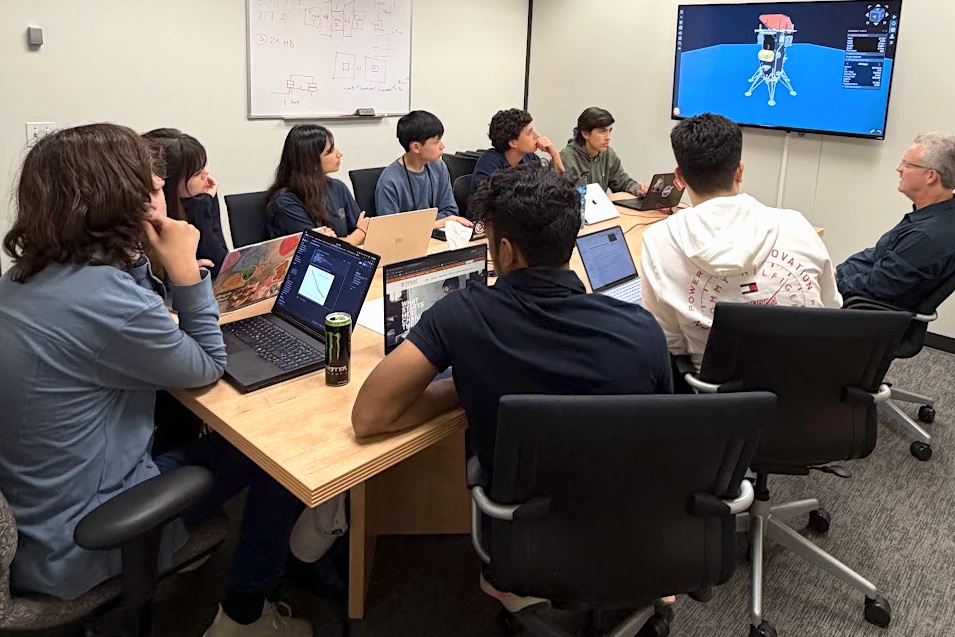
A group of people seated at a wooden table, gathered around a screen on the wall, reviewing the interactive dashboard they built.
The Matrix Team developed a sophisticated interactive dashboard for the IM-3 mission that allows users to vary engine, spacecraft, and orbital parameters to investigate the effect on propellant margins and landing zone availability.

The NASA STEM (Science, Technology, Engineering, and Mathematics) Enhancement in Earth Science (SEES) Internship Program at the University of Texas Center for Space Research places high school students on small, mission-focused research teams mentored by NASA, academic, and industry experts. During summer 2026, the SEES Mission Architecture Tool for Research, Integration, and eXploration (MATRIX) team focused on applying a method for measuring propellant mass in microgravity, where liquid fuel clings to tank walls instead of settling – a challenge central to NASA’s Artemis missions.

The MATRIX team was mentored by Dr. Kevin Crosby, who, along with colleagues at NASA, developed the Modal Propellant Gauging (MPG) approach to microgravity propellant mass gauging at Carthage College in Kenosha, WI. MPG uses the acoustic response of propellant tanks to estimate the mass of fuel inside a tank. The method has been used successfully in several spaceflight experiments and is scheduled for demonstration on the Intuitive Machines IM-3 mission. The IM-3 lander, Trinity, is scheduled to touch down on the Moon in the Reiner Gamma region in 2027. The team developed models for predicting when MPG can take reliable readings during the mission, giving the interns direct experience with a technology preparing for spaceflight and lunar surface operations.

Reconstructing a Lunar Mission from Public Data

The MATRIX team relied entirely on publicly available sources, including Intuitive Machines’ published mission data. The NASA Jet Propulsion Laboratory’s Navigation and Ancillary Information Facility (NAIF) provided detailed trajectory records for the IM-1 and IM-2 missions. By comparing the IM-2 spacecraft’s reconstructed flight path with a model of its motion without engine thrust, the team identified engine burns and estimated the change in velocity associated with each burn.

Because a complete IM-3 trajectory is not public, the team wrote a reconstruction algorithm using published IM-1 and IM-2 flight data. To model fluid behavior, the team ran computational fluid dynamics (CFD) simulations to estimate slosh dynamics within the tanks and conducted Monte Carlo simulations to predict the range of possible propellant states.

Identifying Windows for Measurement

The team’s analysis showed that MPG can take reliable readings during the two primary burns, Lunar Orbit Insertion (LOI) and Powered Descent, and in some cases during Descent Orbit Insertion. The spacecraft’s starting mass had the greatest effect on how long each gauging window lasts. The MATRIX team also identified candidate IM-3 launch opportunities for 2027 and produced a landing analysis for the Reiner Gamma site that showed the distribution of possible landing sites near the target.

Presenting to the Scientific Community

The team briefed the Intuitive Machines propulsion group, walking the engineers through their methods and results and demonstrating that a rigorous analysis of an active lunar mission could be built from public data. The students presented their research, “Computational Models to Estimate Modal Propellant Gauging (MPG) Windows on the Intuitive Machines IM-3 Mission,” at the SEES Annual Symposium and the Wisconsin Space Grant Consortium Annual Conference. The team will present again at the American Geophysical Union (AGU) Annual Meeting in San Francisco in December 2026.

“This high school team, in a period of less than a month, developed a depth of understanding and facility with advanced methods that rivals advanced graduate students in the field,” said Crosby. “Their work product is exceptional, and their presentation to Intuitive Machines engineers impressed everyone with the sophistication and creativity of their work. The SEES program has consistently provided a unique environment for students to demonstrate they can achieve far more than what is asked of them, even in the most advanced classes.”

The SEES program gives 11th and 12th grade students direct experience with the data, tools, and analytical methods used across the aerospace industry. By applying NASA and commercial mission data to an active lunar mission, the MATRIX team contributed analysis relevant to propellant management, a capability needed for in-space refueling, fuel depots, and sustained exploration of the Moon and beyond. Thank you to all the mentors, project assistants, and volunteers who have made SEES possible for over a decade. 

The SEES Mission Architecture (MATRIX) Team:
Raiymbek Abdy, The Woodlands, TX
Emmanuel Bravo, Boca Raton, FL
Winston Huang, San Francisco, CA
Adrianna Krajnovic, Dallas, TX
Marco Lo Cicero, Tomball, TX
Henry Martin, Milwaukee, WI
Reva Paul, Bethlehem, PA
Swayam Sahoo, North Chelmsford, MA

Project Mentor: Dr. Kevin M. Crosby, Carthage College and Wisconsin Space Grant Consortium
Project Assistant: Mauro Esquivel, mathematics teacher, McAllen, TX

For more information, visit: https://www.csr.utexas.edu/sees-internship/

The SEES project is supported by NASA cooperative agreement award number NNH15ZDA004C and is part of the NASA Science Activation Program portfolio, which connects learners with authentic NASA science experiences through partnerships with educators and community organizations.

Share

Details

Last Updated
Oct 27, 2026
Editor
NASA Science Editorial Team
Location
Jet Propulsion Laboratory

NASA’s CASALS Instrument Bridges Gaps in 3D Maps of Earth’s Surface

21 October 2026 at 08:17

From orbit, today’s space-based laser instruments measure Earth’s forests and terrain one narrow line at a time. Between those lines are enormous gaps that include millions of acres of land scientists never directly measure. NASA’s CASALS instrument will blend machine learning with an ultra-compact lidar instrument to adaptively ‘sweep’ large swaths of Earth’s surface. This new capability for space-based remote sensors allows CASALS to create truly three-dimensional (3D) topographical renderings. 

Video from a CASALS flight over the Great Cypress Swamp in Delaware on Nov. 12, 2024, showing tree canopy tops in green, the ground in purple, and near-ground vegetation in blue.
Credit: NASA

A team of researchers at NASA’s Goddard Space Flight Center (GSFC) has developed a new instrument designed to eliminate blind spots between lines of lidar data on the Earth’s surface. Built with support from NASA’s Earth Science Technology Office (ESTO), the Concurrent Artificially-intelligent Spectrometry Lidar System (CASALS) could help researchers map the features of Earth’s surface with unprecedented detail. Rather than mechanically steering a laser with moving mirrors, CASALS steers light using wavelength itself, generating a continuous, 3D swath of the ground below. 

John Yorks, a physical research scientist at GSFC and Principal Investigator for CASALS, explained that the instrument features a novel transmitter and optical grating system that manipulates laser pulses without heavy, failure-prone motorized mirrors. 

Instead, CASALS uses a fast-pulsing, tunable “seed” laser centered at 1040 nanometers, rapidly cycling through 256 unique wavelengths as it pulses through an optical component with a microscopic pattern of ridges called a transmission grating. 

At this point, the physics of diffraction takes over. Because light bends at slightly different angles depending on its exact wavelength, the grating naturally “steers” each of the 256 pulses into a distinct position across the flight path. 

This non-mechanical approach paints a continuous 3D swath of the ground. Not only does this eliminate the large unmapped gaps left between the isolated tracks of legacy spaceborne lidars, but stripping away moving parts drastically reduces the instrument’s size, weight, and power (SWaP) requirements. This makes it more reliable for the harsh environment of space. 

Another key innovation within CASALS is its detector array. This component features a uniquely high Quantum Efficiency (QE), a variable that describes how effectively a detector converts incoming light (photons) into an electrical signal. CASALS operates at 80% QE. This means CASALS wastes almost none of the light that makes it back to the sensor. 

With QE that high, CASALS can detect much weaker return signals, allowing it to collect useful measurements from darker surfaces or through denser vegetation. 

This technology isn’t limited to a laboratory environment. In November 2024, an airborne CASALS prototype flew aboard NASA’s B200 King Air aircraft. The instrument produced science-quality datasets on its first campaign, exceeding the team’s expectations. 

“I’m very impressed with Guang Yang, Jeffrey Chen, and all our engineers, and how well CASALS performed. This worked really well from the first time we flew it, which is pretty impressive,” said Yorks. 

Flying at an altitude of roughly five kilometers, CASALS can distinguish individual tree branches and subtle changes in ground elevation, thanks to its 22-centimeter horizontal resolution. 

“We’re able to see really fine details of vegetation structure and changes in the topography of the surface,” Yorks said. 

The team aims to fly CASALS again as part of the Airborne Surface, Cryosphere, Ecosystem, and Nearshore Topography (ASCENT) campaign, scheduled for summer 2027. 

But there’s more work to do to prepare the technology for space. The team plans to make several improvements to CASALS before creating a space-ready prototype. Specifically, they’re widening the instrument’s swath and adding onboard data processing software. 

Transitioning from a successful airborne prototype to a fully realized space mission is a challenge, but the CASALS team is up to the task. 

“The team’s really done a great job of sticking together and keeping on task and on schedule. We are being funded to optimize and improve the performance, and we’re also then looking at ways to take the technologies used in the airborne instrument and mature them and prepare them for a spaceborne version in the future,” said Yorks. 

If successful, CASALS could become the first spaceborne lidar capable of mapping Earth’s forests and terrain as continuous three-dimensional swaths rather than isolated profiles, giving scientists a dramatically more complete picture of our changing planet. 

For additional details, see the entry for this project on NASA TechPort. 

Project Lead(s): John Yorks, NASA’s Goddard Space Flight Center 

Sponsoring Organization(s): NASA’s Decadal Survey Incubation (DSI) program; NASA’s Instrument Incubation Program (IIP); NASA’s Goddard Space Flight Center; University of California, Santa Barbara; Virginia Polytechnic Institute and State University 

Share

Details

Last Updated
Oct 21, 2026
Editor
NASA Science Editorial Team
Location
Goddard Space Flight Center

NASA Welcomes All Ages, Experience Levels for Space Apps Challenge

15 October 2026 at 12:13

Registration is open for the 2026 NASA Space Apps Challenge, a two-day global event on Saturday, Nov. 14 and Sunday, Nov. 15, where teams work to create solutions inspired by NASA’s most ambitious exploration goals and making use of the agency’s free and open data. The annual challenge, often called a hackathon, is an intensive, collaborative problem-solving experience where participants tackle real-world challenges created by NASA subject matter experts.

This year’s Space Apps Challenge collectively supports three major focus areas: returning humans to the Moon, preparing for missions deeper into the solar system, and expanding understanding of the universe. Participants do not have to be programmers. Students, scientists, engineers, designers, storytellers, technologists, and space enthusiasts of all ages and experience levels can contribute their skills.

“At NASA, science is for everyone, and we’re inviting the next generation to help tackle some of humanity’s most critical challenges in space through the NASA Space Apps Challenge,” said Nicky Fox, associate administrator, Science Mission Directorate, NASA Headquarters in Washington. “Everything in NASA Science is interconnected, and this year, students from around the world can use NASA’s powerful data sets to help us build the ultimate interplanetary survival guide – supporting the science that will enable astronauts to thrive on the Moon and, eventually, Mars, while also inspiring ideas that improve everyday life on Earth and in space for the benefit of all.”

Supporting lunar exploration, Artemis planning

NASA continues to advance plans for a sustained human presence on the Moon through the Artemis program and Moon Base. Several of this year’s Space Apps challenges relate to analytical tools, operational considerations, and human‑system needs relevant to lunar missions. These include work related to surface operations at the Moon’s South Pole, the management of environmental constraints such as sunlight and communications windows, as well as approaches for evaluating the logistical and scientific demands of long‑duration lunar stays. Broader system‑level modeling challenges, such as those that simulate outpost operations or consider astronaut health and safety, mirror the complexity of planning for human activity on the lunar surface.

Strengthening readiness for Mars, deep space

NASA’s exploration strategy includes continued robotic exploration of the outer solar system and preparing for future human missions to Mars. Several challenges involve operational concepts for Martian surface activities, integrating data from multiple Mars missions, or reflecting the mission‑design trade‑offs required for deep‑space exploration. Others address fundamental concerns for long‑duration travel, such as monitoring physiological and behavioral health indicators, or examining how engineering and scientific choices shape mission execution in environments far from Earth.

Some of these challenges also align with NASA’s broader exploration portfolio, which includes ongoing work on future missions to destinations such as Jupiter’s moon Europa and Saturn’s moon Titan. By simulating mission‑design decisions or evaluating environmental analogs on Earth, certain challenges offer frameworks related to how NASA prepares for complex operational scenarios throughout the solar system.

Enhancing access to astrophysics

NASA’s astrophysics missions contribute to understanding the structure and history of the universe. In 2026, this includes active missions like Spectro-Photometer for the History of the Universe, Epoch of Reionization and Ices Explorer (SPHEREx), which is conducting a full‑sky spectral survey, as well as the continued development and deployment of observatories designed to investigate cosmic evolution and exoplanet, which are planets outside our solar system, populations.

Challenges associated with these efforts focus on improving public access to mission data, designing tools that help visualize changes in the sky over time, and supporting broader engagement with the scientific products derived from these missions.

Broader impact across NASA’s mission landscape

Together, these challenges illustrate how NASA’s open data ecosystem enables gold standard science, by freely offering such a wide breadth of information and research. By engaging with the Space Apps event, the entire nation can interact with the kind of real‑world needs defined by the agency.

Registration is available at the NASA Space Apps Challenge. Participants can join in one of 500+ local events, join a team, and select the challenge that they are most interested in addressing during the November hackathon.

NASA’s Curiosity Rover Catches Stunning Martian Dawn

6 October 2026 at 11:30

3 min read

Preparations for Next Moonwalk Simulations Underway (and Underwater)

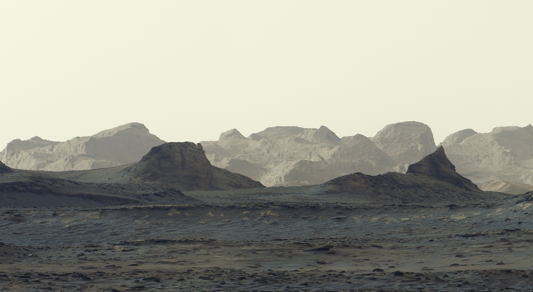
A stark, grayish-tan Martian landscape features jagged rock formations and rolling mountain ridges beneath a pale, hazy sky.
The captivating shapes of wind-carved crags called yardangs are revealed in this zoomed-in crop of a broader panorama captured by NASA’s Curiosity Mars rover on Aug. 11, 2026. Scientists are eager to learn more about how the yardang layer formed.
NASA/JPL-Caltech/MSSS

A newly released panorama captured by NASA’s Curiosity rover offers the most detailed view yet of distant, wind-carved Martian cliffs, highlighting features the mission’s scientists have long been waiting to see up close. The scene was snapped at 8:30 a.m. local Mars time, showing striking blue hues in the foreground as bright morning light illuminates crags known as yardangs on the horizon.  

The panorama was captured by Curiosity’s Mastcam on Aug. 11, the 4,982nd Martian day, or sol, of the mission, and comprises six individual images that were stitched together after being sent to Earth. Unlike most of Curiosity’s Mastcam images, this one was processed without white balancing, preserving the early morning appearance.  

A broad, panoramic view of a stark, grayish-tan Martian landscape features jagged rock formations and rolling mountain ridges beneath a hazy sky. Features in the front are darker while distant rock formations are washed in pale light.
The six shots that make up this panorama, captured by NASA’s Curiosity on Aug. 11, were stitched together after being sent back to Earth. Unlike most images from the rover’s Mastcam, this one was processed without the usual white balancing — an artistic choice that preserves the early morning appearance.
NASA/JPL-Caltech/MSSS

The yardang layer extends roughly 10 miles (16 kilometers) across the northwestern reaches of Mount Sharp, a 3-mile-tall (5-kilometer-tall) mountain that Curiosity has been ascending since 2014. In fact, the rover recently passed another milestone in its ascent, reaching 0.6 miles (1 kilometer) of elevation — the most ever climbed on Mars. As it draws ever-closer to the yardangs, mission scientists expect to get even more amazing imagery — and, they hope, answers to how these cliffs were created. 

Mount Sharp is made up of layers, each recording a distinct period of Mars’ history. By studying them, scientists have been able to learn more about lakes and streams that covered this part of the Red Planet billions of years ago. Eventually, the water dried up and left salty minerals behind. After new material stopped settling on the mountain, some of it may have been stripped away by wind, giving rise to the yardangs. 

A 3D topographical map shows a large Martian crater with a prominent central mountain peak, encircled by a black oval highlighting a specific region near the base of the mound.
This artist’s concept shows Mount Sharp, the 3-mile-tall (5-kilometer-tall) mountain that NASA’s Curiosity has been ascending since 2014. The location of the yardang layer, which the rover recently captured from a distance, is indicated by an ellipse annotation on the mountain’s northwestern shoulder.
NASA/JPL-Caltech/ESA/DLR/FU Berlin/MSSS
A wide panoramic view of a rocky, reddish-brown Martian valley framed by rugged hills under a hazy sky, with a portion of NASA’s Curiosity Mars visible on the far right.
NASA’s Curiosity Mars rover captured this view looking back at the floor of Gale Crater on Sept. 5, 2026. Just nine days prior, the rover had marked 1 kilometer of elevation gain above the crater floor since beginning its ascent of Mount Sharp in 2014.
NASA/JPL-Caltech/MSSS

“The yardang layer looks out of place. It’s the wrong color, the layers tilt at an odd angle, and it almost appears plastered on,” said Ashwin Vasavada, Curiosity project scientist of NASA’s Jet Propulsion Laboratory in Southern California. “But that’s what makes it exciting to reach. No one is sure exactly what created this layer, but one idea is it may be ash deposited by ancient volcanic eruptions.” 

Curiosity is in the second year of its fifth extended mission, which started with an exploration of the spiderweb-like boxwork ridges. The rover will spend most of the next year or so driving through layers enriched with sulfates and carbonates, both signs of ancient drying on the surface. Sometime in 2027, scientists hope to reach the base of the yardangs, where Curiosity will be able to use its robotic arm to collect one-of-a-kind data on these mysterious features. 

More about Curiosity 

Curiosity was built by NASA JPL, which is managed by Caltech in Pasadena, California. NASA JPL leads the mission on behalf of the agency’s Science Mission Directorate in Washington as part of its Mars Exploration Program portfolio. Malin Space Science Systems in San Diego built and operates Mastcam. 

To learn more about Curiosity, visit:

https://science.nasa.gov/mission/msl-curiosity

News Media Contacts

Andrew Good
Jet Propulsion Laboratory, Pasadena, Calif.
818-393-2433
andrew.c.good@jpl.nasa.gov


Karen Fox / Alana Johnson
NASA Headquarters, Washington
240-285-5155 / 202-672-4780
karen.c.fox@nasa.gov / alana.r.johnson@nasa.gov

2026-067

❌
❌
