❌

Normal view

There are new articles available, click to refresh the page.
Yesterday — 30 October 2026Space

Vega Island Frozen in Fright

30 October 2026 at 00:01


March 22, 2025
October 10, 2026

Part of an ice-covered Antarctic island has the appearance of a grinning skull in profile, with a rock outcrop as an eye socket and lateral moraine as a mouth.
NASA Earth Observatory / Lauren Dauphin

Part of an ice-covered Antarctic island has the appearance of a grinning skull in profile. Some of the face has a gray appearance where seasonal snow is gone and bare ice is exposed.
NASA Earth Observatory / Lauren Dauphin

Part of an ice-covered Antarctic island has the appearance of a grinning skull in profile, with a rock outcrop as an eye socket and lateral moraine as a mouth.
NASA Earth Observatory / Lauren Dauphin
Part of an ice-covered Antarctic island has the appearance of a grinning skull in profile. Some of the face has a gray appearance where seasonal snow is gone and bare ice is exposed.
NASA Earth Observatory / Lauren Dauphin

March 22, 2025

October 10, 2026


Shrouded in ice in the lonely Weddell Sea, Vega Island is an eerie sight to behold. On this speck of land east of the Antarctic Peninsula, ice, rock outcrops, and glacial moraines combine to create the appearance of a smirking skull in profile looking toward Devil Island.

These images show Vega Island’s creepy countenance at the start of austral autumn (left) and in spring (right). They were acquired with the OLI (Operational Land Imager) on Landsat 9 on March 22, 2025, and October 10, 2026, respectively. (Clouds obscured the island in March 2026.) A nunatak jutting out of the ice has the appearance of an eye socket, a lateral moraine forms a mouth, and Bahía del Diablo (Devil’s Bay) Glacier constitutes a jawbone. In the March 2025 image, a layer of snow coats the ice, which is typical of the region’s wettest month. That contrasts with the October 2026 image, when snow is absent from large areas and darker ice surfaces are visible.

Above-average temperatures in winter 2026—particularly in June—were partly responsible for so much bare ice in October, said glaciologist Mauri Pelto of Nichols College. The ice exposed on Vega and nearby islands indicates limited new snow accumulation over the winter, further reduced by sublimation and wind scouring, he said. “The winter season was no treat for these glaciers.”

The melt season ahead may also be more trick than treat. Bare ice is darker than snow and absorbs more solar energy, meaning that melting is poised to speed up as the days grow longer and warmer. “Even a thin cover of new snow from a spring storm would be helpful in the short run,” Pelto said. “When entombed in snow and ice, the skull is preserved. But when exposed to melt, it weathers away, which will lead to a changing jawline and expanding eye socket.”
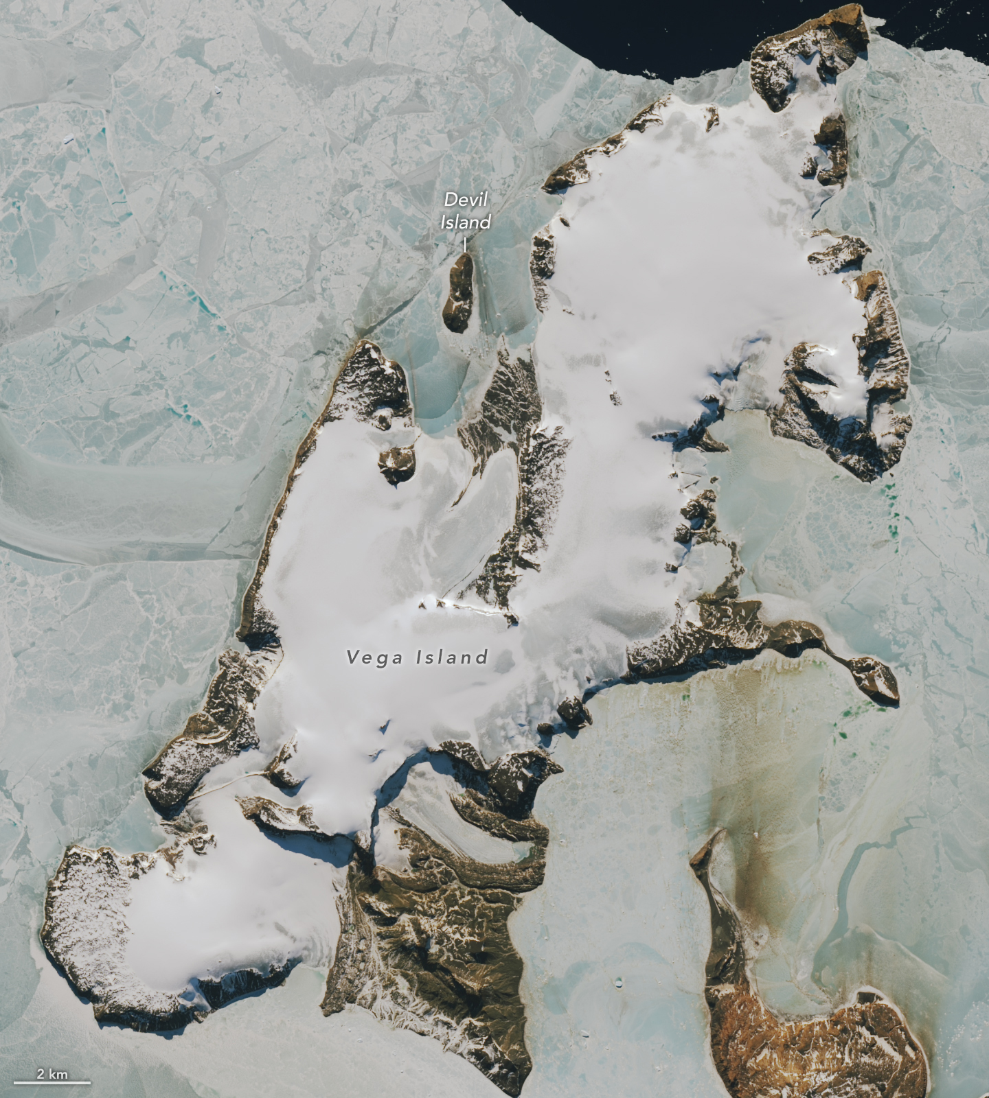
Part of an ice-covered Antarctic island has the appearance of a grinning skull in profile. Some of the face has a gray appearance where seasonal snow is gone and bare ice is exposed.
October 10, 2026
NASA Earth Observatory/Lauren Dauphin

The first comprehensive mapping of Vega Island’s ice was aided by Landsat imagery. In a study published in 1982, scientists described the island’s four ice caps with protruding rocky cliffs and outlet glaciers. They leveraged early Landsat observations along with aerial photos and topographic maps to catalog 29 glaciers on Vega.

Of those glaciers, Devil’s Bay Glacier has been closely monitored since the austral summer of 1998-1999, with researchers measuring an overall decline in its mass. Satellite images acquired in recent decades show ice loss from other glaciers on the island as well, with increased areas of exposed bedrock.

Long before scientists began tracking its glaciers, Vega was a bright spot in a tale of terror born out of early exploration of the area. The Swedish Antarctic Expedition of 1901-1903 set out to study the geography, geology, climate, and wildlife on and around the eastern Antarctic Peninsula. The party became split into three groups during their explorations, isolated for a winter in different locations. Adding to the horror, they lost their ship to the pack ice. Cape Well-met, as it would come to be known, off the “forehead” of the Vega Island skull, was the site of a happy reunion of two of the groups in spring 1903. Soon thereafter, an Argentinean expedition rescued the survivors of the ordeal.

NASA Earth Observatory images by Lauren Dauphin, using Landsat data from the U.S. Geological Survey. Story by Lindsey Doermann.

Downloads

Part of an ice-covered Antarctic island has the appearance of a grinning skull in profile, with a rock outcrop as an eye socket and lateral moraine as a mouth.

March 22, 2025

JPEG (303.91 KB)

Part of an ice-covered Antarctic island has the appearance of a grinning skull in profile. Some of the face has a gray appearance where seasonal snow is gone and bare ice is exposed.

October 10, 2026

JPEG (383.70 KB)

References & Resources

You may also be interested in:

Stay up-to-date with the latest content from NASA as we explore the universe and discover more about our home planet.

Ice Island Survives Run-In With Joe Island

5 min read

In summer 2026, a substantial iceberg calved from Petermann Glacier in northwest Greenland and swiftly drifted into Nares Strait, colliding…

Article

A Bare Summer for Barnes Ice Cap

4 min read

The expanse of glacial ice on Canada’s Baffin Island lost its snow cover quickly and early in summer 2026, revealing…

Article

Pasterze Hangs on as Austria’s Largest Glacier

4 min read

One narrowing icefall remains the linchpin for the Alpine glacier—and it may not be long for this world.

Article
Before yesterdaySpace

A-81 Reaches South Georgia

27 October 2026 at 00:00
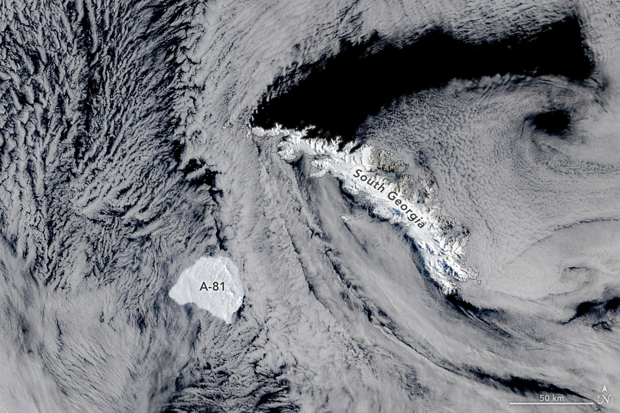
A large, blocky iceberg sits in dark ocean water just southwest of a long, narrow, snow-capped island. Thin clouds partly veil the scene.
Iceberg A-81 slows its drift near the edge of South Georgia’s shallow underwater shelf in this image, acquired on October 20, 2026, by the MODIS (Moderate Resolution Imaging Spectroradiometer) on NASA’s Terra satellite.
NASA Earth Observatory/Michala Garrison

Some Antarctic icebergs linger close to home for decades, running aground near the ice shelves that spawned them or circling partway around the continent on coastal currents. Others, like Iceberg A-81, make a faster exit, heading north out of the Weddell Sea along a route well-traveled by the region’s bergs.

Fast is relative, though. After breaking from the Brunt Ice Shelf in January 2023, the roughly 1,550-square-kilometer (600-square-mile) berg spent more than three years in the Weddell Sea, carried along the coast by the clockwise-flowing Weddell Gyre. By May 2026, it reached the tip of the Antarctic Peninsula. It then moved north into the Scotia Sea, and by late October 2026, it approached the remote island of South Georgia in the South Atlantic Ocean, 2,300 kilometers (1,400 miles) north-northwest of the Brunt Ice Shelf.

This image, acquired by the MODIS (Moderate Resolution Imaging Spectroradiometer) on NASA’s Terra satellite, shows the berg on October 20. In the days before, its progress slowed noticeably, and it appeared to be bumping along the edge of the island’s underwater shelf, according to Jan Lieser of Australia’s Bureau of Meteorology and Christopher Shuman of the University of Maryland (retired). South Georgia has slowed and even stopped icebergs before. In 2025, for instance, Iceberg A-23A ran aground on the shelf and later broke apart.

Though Iceberg A-81 was a steadfast traveler once it broke free, it took its time in becoming an iceberg in the first place. For about 35 years, one of the Brunt Ice Shelf’s rifts known as Chasm 1 was relatively stable. Then, around 2012, it began growing again, and by 2019, it was advancing quickly enough that a break seemed imminent. But the floating glacial ice held on for several more years until finally, in January 2023, the berg let go.

Calving is a normal part of the life cycle of ice shelves, but scientists keep a close eye on Brunt, which has recently shed several large icebergs in quick succession and is home to the British Antarctic Survey’s Halley Research Station, a major base for Earth, atmospheric, and space science research since the 1950s. Besides A-81, the ice shelf calved Iceberg A-74 from the North Rift in 2021 and Iceberg A-83 from the Halloween Crack in 2024. A-74 has since broken up, while A-83 remains intact and is trailing A-81 northward, along with a handful of other icebergs that appear to be clearing out of the Weddell Sea.

NASA Earth Observatory image by Michala Garrison, using MODIS data from NASA EOSDIS LANCE and GIBS/Worldview. Story by Kathryn Hansen.

Downloads

A large, blocky iceberg sits in dark ocean water just southwest of a long, narrow, snow-capped island. Thin clouds partly veil the scene.

October 20, 2026

JPEG (2.14 MB)

References & Resources

You may also be interested in:

Stay up-to-date with the latest content from NASA as we explore the universe and discover more about our home planet.

An Uncommon Drifter in the Denmark Strait

4 min read

A large iceberg, observed in summer 2026, had drifted more than 1,000 kilometers south from the northeastern Greenland bay where…

Article

A Changing World for Emperor Penguins

7 min read

Experts are analyzing decades of images from Landsat satellites for clues about how the iconic birds have responded to sea…

Article

Antarctic Sea Ice Grows to Its 2026 Maximum

3 min read

The ice reached its third-lowest maximum extent since satellite observations began.

Article

Uncovering the Valleys Hidden Below Greenland’s Ice

28 September 2026 at 00:00
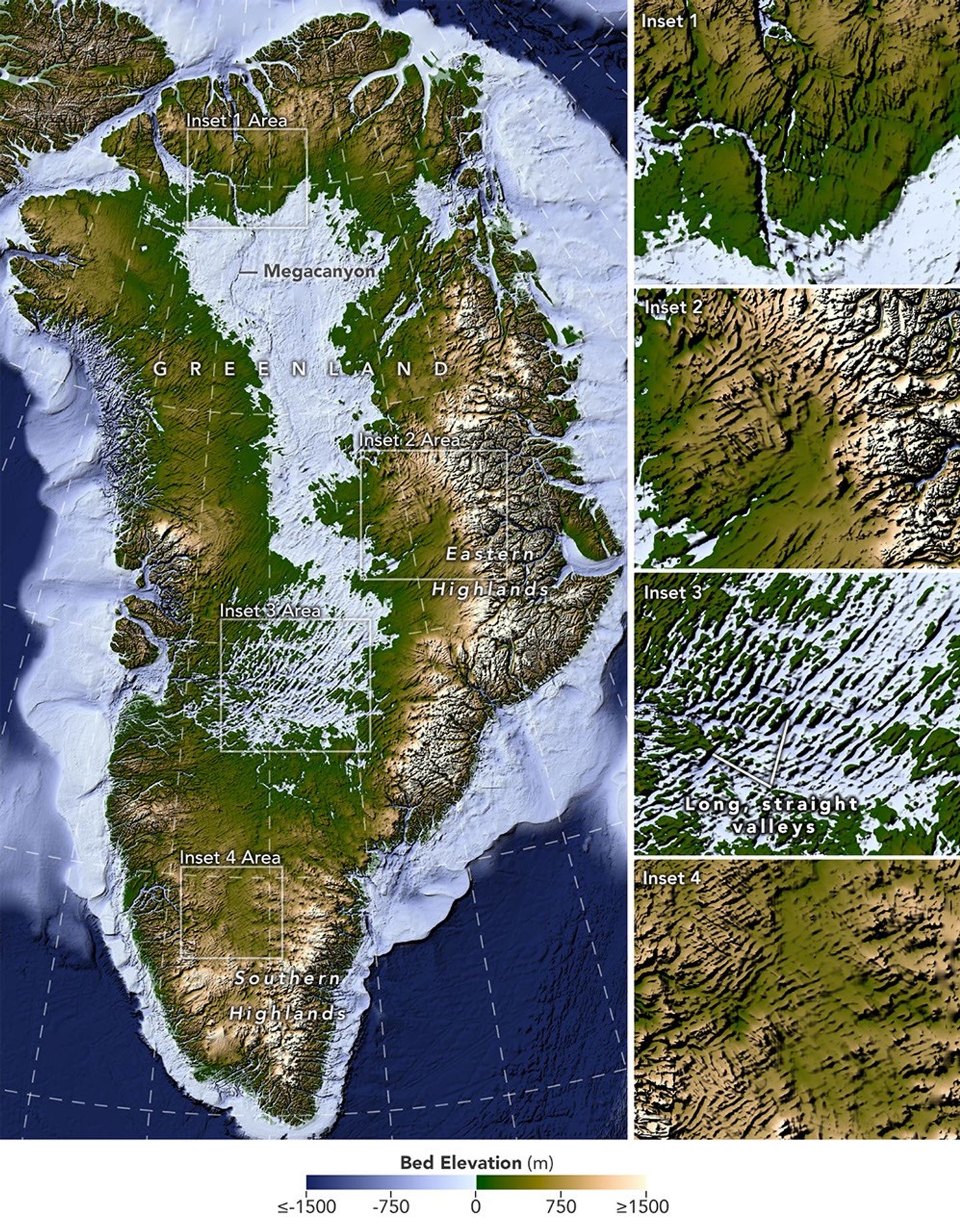
A large map on the left shows Greenland’s bedrock topography that lies below the ice sheet. A column of smaller maps on the right zooms in on several features, including long, straight valleys on the west-central part of the island. Other insets show a megacanyon, as well as valleys radiating outward from the highlands.
A newly developed method for mapping the bedrock beneath Greenland’s ice sheet reveals the island’s hidden topography. Among the most striking finds are long, straight valleys in the west-central region, some mapped for the first time and others extending farther inland than previously known (inset 3).
NASA Earth Observatory/Lauren Dauphin, based on data from Chartrand et al.

Greenland is capped with a vast ice sheet that spans 1.7 million square kilometers (656,000 square miles) and measures more than 3 kilometers (1.9 miles) at its thickest point. Below all this ice lies a landscape human eyes have never seen directly. But a newly developed method for mapping this hidden bedrock has produced the most detailed and accurate view of it yet.

The new map reveals an expansive network of valleys carved into the surface beneath the Greenland Ice Sheet. Many of the features formed well before most of the ice above them existed, offering new context for the island’s geologic history—and potentially helping scientists refine projections of the ice sheet’s future. Scientists described the newly mapped valleys in a NASA-led paper published in Geophysical Research Letters.

The map, shown above, was derived from a method called Ice Flow Perturbation Analysis. As ice flows over a valley or ridge, the topography leaves a faint signature on the ice surface. Satellites map the ice surface in fine detail, and scientists can use these subtle bumps and dips to infer the shape of the landscape buried below. The work aims to improve future versions of BedMachine Greenland, a high-resolution dataset of the terrain beneath the ice sheet.

Using the technique, researchers manually mapped 1,943 subglacial valleys beneath the Greenland Ice Sheet, about a third of which are newly identified. About half of the valleys included in BedMachine Greenland, primarily near the ice sheet’s edge, are now known to extend farther inland than that map indicates, in some cases by hundreds of kilometers.

Some aspects of the new map align with the current understanding of how Greenland’s landscapes formed. For instance, many of the valleys appear to begin in the southern and eastern highlands, where the ice sheet is thought to have first formed. Near the eastern highlands, the map reveals a mountain range beneath the ice, with interconnected valleys and relief that increases toward the coast. These alpine-style landforms may have survived under the ice since at least the Pliocene.

Other aspects of the topography are more puzzling. The analysis indicates numerous valleys, especially in the west-central region, that are long, straight, and consistently aligned in a southwest-northeast direction. This orientation suggests a tectonic influence, generating preferential pathways along which water could flow and valleys could form. “That’s a riddle to us,” said Joe MacGregor, a NASA cryospheric scientist and co-author of the study. “Greenland is justifiably usually treated as a rigid block of old rock that is simply translated as needed to accommodate the motion and interactions of other tectonic plates.”

Separately, the angles at which the valleys branch offer another insight into their origin. Their relatively wide branching angles suggest that surface water didn’t act alone; instead, a widespread groundwater network—seeping upward and eroding the surrounding rock—likely helped carve the valleys before the ice sheet formed.

Mapping these valleys matters for understanding the ice sheet, which has continued to dramatically reshape the landscape. Ice flow concentrates in valleys, where it forms glaciers that eventually calve into fjords at the periphery of the ice sheet. This creates a reinforcing cycle: ice funneling through a valley gets thicker, thicker ice flows faster, and faster flow carves the valley even deeper.

This carving power is especially evident along western Greenland. MacGregor likened it to the glacially incised landscape at Yosemite, with Greenland’s western coast resembling, as he put it, “El Capitan after El Capitan.”

Studying the valleys also matters for the ice sheet’s future. Because the relationship between ice flow and valleys is well understood, scientists expect that as the ice sheet retreats, flow will continue to concentrate wherever the valleys already are. “The better we understand the topography now,” MacGregor said, “the better sense we’ll have of what it will look like in the longer term—beyond the next decade or two—as faster ice flow propagates into Greenland’s interior.”

NASA Earth Observatory map by Lauren Dauphin using data from Chartrand et al. Story by Kathryn Hansen.

Downloads

A large map on the left shows Greenland’s bedrock topography that lies below the ice sheet. A column of smaller maps on the right zooms in on several features, including long, straight valleys on the west-central part of the island. Other insets show a megacanyon, as well as valleys radiating outward from the highlands.

Bedrock Map

JPEG (11.10 MB)

References & Resources

You may also be interested in:

Stay up-to-date with the latest content from NASA as we explore the universe and discover more about our home planet.

An Uncommon Drifter in the Denmark Strait

4 min read

A large iceberg, observed in summer 2026, had drifted more than 1,000 kilometers south from the northeastern Greenland bay where…

Article

A Bare Summer for Barnes Ice Cap

4 min read

The expanse of glacial ice on Canada’s Baffin Island lost its snow cover quickly and early in summer 2026, revealing…

Article

Pasterze Hangs on as Austria’s Largest Glacier

4 min read

One narrowing icefall remains the linchpin for the Alpine glacier—and it may not be long for this world.

Article
❌
❌