❌

Normal view

There are new articles available, click to refresh the page.
Today β€” 29 July 2026Space

Sizing Up theΒ SargassumΒ Belt

29 July 2026 at 00:00
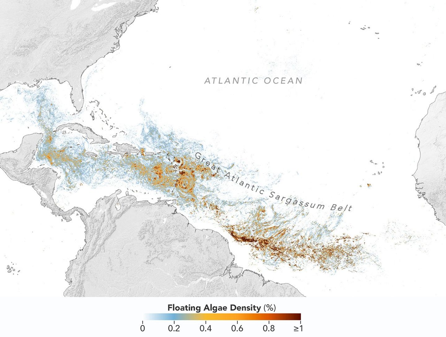
Map of the Atlantic Ocean showing Sargassum density from low (blue) to high (red) in June 2026, with the highest concentrations in the tropical Atlantic.
This map, based on data from the OCI (Ocean Color Instrument) on NASA’s PACE (Plankton, Aerosol, Cloud, ocean Ecosystem) satellite, shows Sargassum highly concentrated in the tropical Atlantic in June 2026.
NASA Earth Observatory/Lauren Dauphin

Sargassum, a type of brown floating algae, has shifted its range in recent decades, thinning out in the North Atlantic’s Sargasso Sea while proliferating in the tropical Atlantic. That trend, underway since 2011, continued in 2026 as the algae, commonly known as a type of seaweed, reached its annual peak in June across a stretch of ocean known as the Great Atlantic Sargassum Belt.

The belt’s Sargassum abundance in June 2026 made it the second-highest Sargassum year in the satellite record, slightly behind 2025, according to scientists at theΒ University of South FloridaΒ (USF) College of Marine Science. Regionally, the Caribbean Sea and the Gulf of America (Gulf of Mexico) both hit record highs, according to USF’s June 2026 Sargassum outlook. The western and eastern Caribbean saw 3.6 and 9 million metric tons, respectively, while the Gulf saw 5 million metric tonsβ€”nearly double its previous record, also set in 2025.Β 

β€œThe belt is a basin-scale phenomenon that can have devastating local-scale impacts throughout the Caribbean and Gulf, and satellite observations are the only method that captures both scales on a daily basis,” said Brian Barnes, a marine scientist at the Optical Oceanography Laboratory at USF. β€œThe tracking done by our lab helps communities know the current extent of Sargassum and prepare for what’s to come.”

In moderate amounts in the open ocean, Sargassum provides habitat for turtles, invertebrates, fish, and birds, and adds oxygen to the water through photosynthesis. But too much of it near shore can tangle and suffocate marine life, and mats that sink can smother corals and seagrasses. On beaches, decomposing Sargassum releases hydrogen sulfide, a rotten-egg-smelling gas that’s a potential problem for both ecosystems and tourism.

The map above showsΒ SargassumΒ density in the tropical Atlantic Ocean in June 2026. Red and orange areas are where Sargassum densities were the highest. Note that although the β€œbelt” appears continuous, discrete Sargassum mats are scattered across the ocean surface. The map is based on satellite measurements of how much of the ocean surface was covered by the seaweed, averaged per pixel across all observations made in June by the OCIΒ (Ocean Color Instrument) on NASA’s PACEΒ (Plankton, Aerosol, Cloud, ocean Ecosystem) satellite.
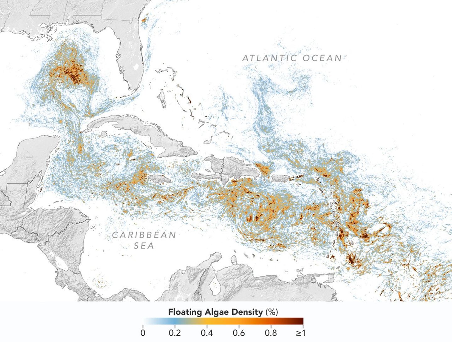
A detailed map of the Atlantic Ocean centered on the Caribbean Sea shows Sargassum density from low (blue) to high (red) in June 2026.
This detailed view of the same PACE OCI map highlights Sargassum concentrations across the Caribbean Sea and Gulf of America, both of which saw record-high amounts of the floating algae in June 2026.
NASA Earth Observatory/Lauren Dauphin

Ocean currents and winds shape the Sargassum belt, which, despite the patchiness, stretches nearly continuously from West Africa to the Gulf and holds a fairly steady β€œwidth” from the western tropical Atlantic westward, explained Chuanmin Hu, also an optical oceanographer at USF. The ocean currents have also spared Florida’s west coast from inundation this summer, while delivering large amounts of seaweed to the Florida Keys and the state’s east coast. The bulk of the Sargassum, however, is visible in the Caribbean Sea, shown in detail above, where problems associated with inundation have been more severe, Hu said.

Data for the maps were provided by Lin Qi, an oceanographer at NOAA’s Center for Satellite Applications and Research, who has been working to generate Sargassum maps based on data from PACE, which was launched in February 2024. The work extends that of Qi and colleagues at USF’s Optical Oceanography Laboratory. This team first developed Sargassum detection techniques using MODISΒ (Moderate Resolution Imaging Spectroradiometer)Β on NASA’s long-running Terra and Aqua satellites and VIIRS (Visible Infrared Imaging Radiometer Suite) on the NOAA-20 satelliteβ€”data that have been a key component of USF’s Sargassum Watch System and of research into the seaweed’s longer-term trends.

Satellites detect Sargassum by its signals in reflected sunlight. Because of its plant structure and chlorophyll pigments, Sargassum reflects more near-infrared light than water. Scientists flag pixels where the reflectance spikes above the levels produced by plain seawater, and then they use the strength of this spike to estimate Sargassum density, which refers to the fraction of ocean surface covered by the seaweed in each pixel. Density estimates can then be converted into biomass, or the total weight of Sargassum present within a pixel, which is how the longer-term trends in the chart below are tracked.
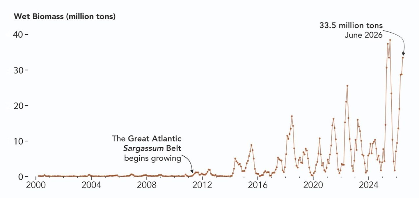
A chart of Sargassum biomass detected by MODIS since the early 2000s, showing amounts increasing beginning in 2011, with progressively higher spikes through summer 2025 and 2026.
NASA Earth Observatory/Lauren Dauphin

The chart above uses the continuous MODIS record since March 2000 to show how Sargassum biomass across the Great Atlantic Sargassum Belt has changed through June 2026. Notice the uptick beginning around 2011, when the belt was first developing, and the seasonal dips in winter and peaks in spring and summer. The record high in July 2025 stands out, followed by the quick rise in early 2026β€”especially in the first four months of the yearβ€”that culminated in the year’s peak in June. More recent observations, not yet reflected in the chart, indicate Sargassum biomass declined through the following month of July.

β€œSince the initial appearance of the Great AtlanticΒ SargassumΒ Belt in 2011, the totalΒ SargassumΒ amount in the Atlantic Ocean has increased substantially, more than doubling every five years,” Hu said. He added that the exact mechanism is still being investigated, but it’s possibly related to ocean warming, multiple nutrient sources, and the fact that large Sargassum mats attract other organismsβ€”such as nitrogen-fixing bacteriaβ€”that can supply additional nutrients to sustain further growth.

Alongside data from MODIS and VIIRS, OCI data from PACE now feeds into the Sargassum Watch System’s near-real-time daily and weekly composite maps. A recent study of the central-west Atlantic led by Qi, spanning May through August 2024, found that OCI offers several advantages over its predecessors, observing more of the ocean and detecting Sargassum with greater sensitivity.Β Β 

Hu noted that the added pixels from OCI can improve near-real-time monitoring and analyses of short-term fluctuations. And its higher sensitivity, he said, will also lead to improved maps during winter months, β€œthus helping understand Sargassum changes over time.”

Additionally, the study’s authors found that OCI’s hyperspectral capability makes it the only sensor able to spectrally discriminate SargassumΒ pixels across the Atlantic Ocean β€œwithout ambiguity,” adding confidence to the interpretation of detected image featuresβ€”especially in parts of the Atlantic where another type of floating algae, Trichodesmium, has been reported.

β€œI think I can speak for all project members, past and present, in sharing how rewarding it is to see the promise of PACE’s advancements come to life,” said Jeremy Werdell, PACE project scientist at NASA’s Goddard Space Flight Center. β€œOCI has started a true renaissance in aquatic ecosystem monitoring from space.”

NASA Earth Observatory maps and chart by Lauren Dauphin, using PACE and MODIS data courtesy of Lin Qi (NOAA), and Brian Barnes and Chuanmin Hu (University of South Florida, Optical Oceanography Laboratory). Story by Kathryn Hansen.

Downloads

Map of the Atlantic Ocean showing Sargassum density from low (blue) to high (red) in June 2026, with the highest concentrations in the tropical Atlantic.

June 2026

JPEG (2.43 MB)

References & Resources

You may also be interested in:

Stay up-to-date with the latest content from NASA as we explore the universe and discover more about our home planet.

Color Off the Mid-Atlantic Coast

4 min read

Something is brewing in shallow waters offshore of Delaware, New Jersey, Maryland, and Virginia.

Article

A Turquoise Tint for the Black Sea

3 min read

Phytoplankton added a milky blue hue to the waters of the Black Sea and nearby waterways in spring and summer…

Article

El NiΓ±o Is Underway

4 min read

Satellite observations of sea surface height indicated that the 2026 event continued to strengthen in early June.

Article
Before yesterdaySpace

Examining Algal Blooms in Blue Mesa

6 July 2026 at 00:01


November 15, 2017
November 17, 2021

The first of a pair of satellite images shows the reservoir in November 2017, when water levels were relatively high and its color was mostly blue.
Cyanobacteria blooms turned Blue Mesa Reservoir green from September through November 2021, when water levels were among the lowest on record. The OLI (Operational Land Imager) on Landsat 8 captured this image (right) of a bloom on November 17, 2021, when the water was near its lowest level; the left image shows the same area on November 15, 2017, when water levels were closer to normal.
NASA Earth Observatory / Lauren Dauphin

The second image in the pair shows the same part of the reservoir in November 2021, when water levels were much lower and its color was much greener.
Cyanobacteria blooms turned Blue Mesa Reservoir green from September through November 2021, when water levels were among the lowest on record. The OLI (Operational Land Imager) on Landsat 8 captured this image (right) of a bloom on November 17, 2021, when the water was near its lowest level; the left image shows the same area on November 15, 2017, when water levels were closer to normal.
NASA Earth Observatory / Lauren Dauphin

The first of a pair of satellite images shows the reservoir in November 2017, when water levels were relatively high and its color was mostly blue.
Cyanobacteria blooms turned Blue Mesa Reservoir green from September through November 2021, when water levels were among the lowest on record. The OLI (Operational Land Imager) on Landsat 8 captured this image (right) of a bloom on November 17, 2021, when the water was near its lowest level; the left image shows the same area on November 15, 2017, when water levels were closer to normal.
NASA Earth Observatory / Lauren Dauphin
The second image in the pair shows the same part of the reservoir in November 2021, when water levels were much lower and its color was much greener.
Cyanobacteria blooms turned Blue Mesa Reservoir green from September through November 2021, when water levels were among the lowest on record. The OLI (Operational Land Imager) on Landsat 8 captured this image (right) of a bloom on November 17, 2021, when the water was near its lowest level; the left image shows the same area on November 15, 2017, when water levels were closer to normal.
NASA Earth Observatory / Lauren Dauphin

November 15, 2017

November 17, 2021


Cyanobacteria blooms turned Blue Mesa Reservoir green from September through November 2021, when water levels were among the lowest on record. The OLI (Operational Land Imager) on Landsat 8 captured this image (right) of a bloom on November 17, 2021, when the water was near its lowest level; the left image shows the same area on November 15, 2017, when water levels were closer to normal.

The summers of 2021 and 2022 were tough seasons for Colorado’s Blue Mesa Reservoir. A severe drought gripped much of the western U.S., prompting emergency water releases that brought the reservoir to its lowest level since 1984. Marinas and boat ramps closed, remnants of a ghost town emerged from the muck, and parts of the reservoir turned greenish and swirled with toxic cyanobacteria blooms.

Research conducted by scientists at the U.S. Geological Survey and the National Park Service analyzed decades of Blue Mesa Reservoir data and found a connection between low water levels, warm water temperatures, and harmful blooms.

β€œAlgal blooms were more common when water levels were below 7,470 feet and water temperatures were above approximately 19.5 degrees Celsius (67.1 degrees Fahrenheit),” said Tyler King, a research hydrologist with U.S. Geological Survey. Water levels that low are relatively common and have occurred every few years in recent decades. Β 

While some cyanobacteria, also called blue-green algae, are always present in the reservoir in small numbers, problems occur when certain types proliferate. Aphanizomenon, Dolichospermum, and Woronichinia, for instance, thrive when the reservoir’s waters become warm and stagnant, releasing a toxin called microcystin that can cause skin and eye irritation, respiratory problems, and liver damage. Children and pets are particularly vulnerable to microcystin poisoning because of their size and tendency to ingest more water than adults.

King and colleagues analyzed in situ water samples and satellite observations from the European Space Agency’s Sentinel-2 mission and the NASA/U.S. Geological Survey Landsat satellites. A Sentinel-2 sensor that detects the light-harvesting pigment chlorophyll was particularly useful for mapping the blooms, while Landsat sensors were used to map water temperatures over time.

The National Park Service and U.S. Geological Survey launched the project in 2021 after anecdotal reports and water sampling suggested elevated cyanobacteria concentrations, King said. The scientists collected water samples but also turned to historical records and satellite data—”like a time machine,” he saidβ€”to examine conditions before regular water sampling had begun. Their analysis included satellite records of chlorophyll levels that extended back to 2016 and temperature records that reached back to 2000. The research team also studied in situ data on water levels dating to the 1970s.

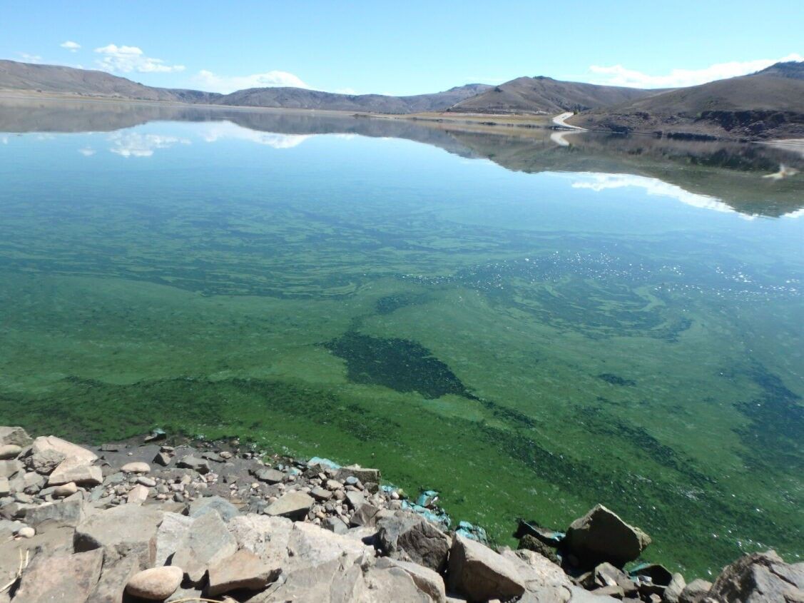
A photograph taken from a rocky shoreline along the Iola Basin show mats of green growth coating the surface of the water.
A cyanobacteria bloom turned the water surface of Iola Basin green on September 8, 2021. Photo by Nicole Gibney/National Park Service.

The satellite data showed that blooms typically start in the eastern end of the reservoir, an area known as Iola Basin. The basin, where the Gunnison River flows into the reservoir, is the shallowest part of the reservoir. Occasionally, the satellite data showed, blooms spread westward into other parts of the reservoir, sometimes moving about two-thirds of the way across. However, concentrations of toxins rarely reached levels that posed health concerns beyond Iola Basin.

The same dynamics that caused challenges for Blue Mesa in 2021 and 2022 are present in 2026, said King. Drought again plagues much of the western U.S., the mountains hold little snow, and water levels in Blue Mesa are low. On June 27, 2026, the reservoir stored about 43 percent of the water it typically does on that date, the lowest value observed for that day in the past 30 years. Water levels are expected to continue dropping until October, according to U.S. Bureau of Reclamation projections.Β 

If cyanobacteria blooms emerge in 2026, the researchers expect that satellites will help scientists track them. The researchers use the U.S. Geological Survey’s WaterMAP (Water Monitoring Above the Planet) tool to monitor for potential bloom conditions within hours of satellite overpasses. NASA’s STREAM (Satellite-based Tool for Rapid Evaluation of Aquatic Environments) project also uses data from Landsat and Sentinel-2 to map potential blooms within hours of a satellite overpass, and the multi-agency CyAN (Cyanobacteria Assessment Network) project collects daily data from other satellites to map blooms in larger water bodies.

β€œIt’s amazing that we can use satellites to map the impacts of microscopic organisms from almost 500 miles away,” King said. Yet it will still be crucial to get people out on the water taking samples and directly testing for toxins, he emphasized. β€œThe satellites aren’t definitive,” he added. β€œThey can tell us where there might be a problem, but toxins often aren’t present until the later stages of a bloom.”

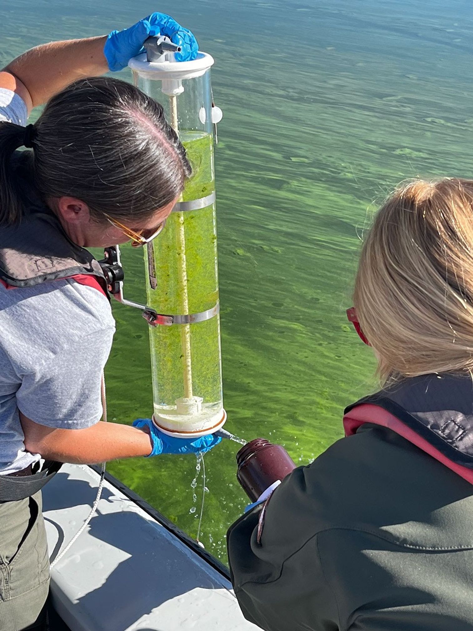
A photograph shows two female researchers collecting green, algae-rich water in a cylindrical container.
Satellite observations can help managers decide where to send personnel to collect water samples for more detailed analysis of bloom toxicity. Photo by Katie Walton-Day/USGS.

NASA Earth Observatory images by Michala Garrison, using Landsat data from theΒ U.S. Geological Survey. Photos by Katie Walton-Day (USGS) and Nicole Gibney (NPS). Story by Adam Voiland.

Downloads

The first of a pair of satellite images shows the reservoir in November 2017, when water levels were relatively high and its color was mostly blue.

November 15, 2017

JPEG (8.98 MB)

The second image in the pair shows the same part of the reservoir in November 2021, when water levels were much lower and its color was much greener.

November 17, 2021

JPEG (8.46 MB)

References & Resources

You may also be interested in:

Stay up-to-date with the latest content from NASA as we explore the universe and discover more about our home planet.

Low Water at San Carlos Reservoir

4 min read

Drought and water releases drained the Arizona reservoir to levels that have led to widespread fish deaths.

Article

Rising Waters Swamp Lake Naivasha

6 min read

Relentless rains are threatening a lake in Kenya’s Great Rift Valley that has become a key hub in the global…

Article

Snow Is Scarce in the Upper Colorado Basin

5 min read

The mountains of Utah and Colorado are among the areas of the western U.S. that are low on snow and…

Article
❌
❌