
Normal view

There are new articles available, click to refresh the page.
Before yesterdayMain stream

Ribbon-Cutting Event for NASA Deep Space Network’s Deep Space Station 23

30 August 2026 at 10:57
2 Min Read

Ribbon-Cutting Event for NASA Deep Space Network’s Deep Space Station 23

Ten people in professional attire pose together outside under a clear blue sky, with a massive white satellite dish standing directly behind them.
PIA26779
Credits:
NASA/JPL-Caltech

Downloads

Ribbon-Cutting Event for NASA Deep Space Network’s Deep Space Station 23

JPEG (1.10 MB)

Description

Leadership from NASA Headquarters, the Jet Propulsion Laboratory, and the Deep Space Network (DSN) stand in front of the recently completed Deep Space Station 23 antenna at the Deep Space Network’s Goldstone complex near Barstow, California, on Aug. 25, 2026. 

From left: Germaine Aziz (project manager, DSN Aperture Enhancement Project, JPL); Bradford Arnold (manager, Telecom Programs & Oversight, JPL); Keyur Patel (associate lab director for Flight Projects & Mission Success, JPL); Wanda Peters (deputy associate administrator, Research and Technology Mission Directorate, NASA Headquarters); Jimmy Kenyon (associate administrator, RTMD, NASA Headquarters); John McCullough (acting director, Space Communications and Navigation Program, NASA Headquarters); Gregory Heckler (deputy program manager for capability development, SCaN, NASA Headquarters); William Marinelli (development manager, SCaN, NASA Headquarters), Michael Levesque (project manager, DSN, JPL); and Frank Kaufholod (project manager, NASA Glenn Research Center).

They gathered at the recently completed DSS-23 antenna for a ceremonial ribbon cutting on Aug. 25, 2026. It’s the latest antenna to be added as part of the DSN’s Aperture Enhancement Project, which began in 2009 to upgrade and expand the network by adding six new 34-meter (114-foot) multifrequency beam-waveguide antennas. These versatile Deep Space Network dishes can enhance many missions operating over different radio frequencies. 

The DSN allows missions to track, send commands to, and receive scientific data from faraway spacecraft. It is managed by JPL, a division of Caltech, in Southern California for SCaN, which is located at NASA Headquarters within RTMD.

For more information about the DSN, visit:

https://www.nasa.gov/communicating-with-missions/dsn/
NASA Deep Space Network’s New Goldstone Antenna Goes Online

30 August 2026 at 10:53
1 Min Read

NASA Deep Space Network’s New Goldstone Antenna Goes Online

A massive white satellite dish antenna stands on a desert plain under a clear blue sky, bathed in warm sunlight alongside small facility structures.
PIA26778
Credits:
NASA/JPL-Caltech

Downloads

NASA Deep Space Network’s New Goldstone Antenna Goes Online

JPEG (1.26 MB)

Description

Long shadows are cast by the recently completed Deep Space Station 23 at the Deep Space Network’s Goldstone complex near Barstow, California, in August 2026. A 34-meter (114-foot) multifrequency beam-waveguide antenna, DSS-23 will boost the DSN’s capacity and enhance NASA’s deep space communications capabilities for decades to come.

NASA leadership and personnel as well as dignitaries gathered at the complete DSS-23 antenna for a ceremonial ribbon cutting on Aug. 25, 2026. It’s the latest antenna to be added as part of the Deep Space Network’s Aperture Enhancement Project, which began in 2009 to upgrade and expand the network by adding six new 34-meter multifrequency beam-waveguide antennas. These versatile Deep Space Network dishes can enhance many missions operating over different radio frequencies. 

The DSN allows missions to track, send commands to, and receive scientific data from faraway spacecraft. It is managed by NASA’s Jet Propulsion Laboratory, a division of Caltech, in Southern California for the agency’s Space Communications and Navigation (SCaN) Program, which is located at NASA Headquarters within the Research and Technology Mission Directorate.

For more information about the DSN, visit:

https://www.nasa.gov/communicating-with-missions/dsn/
Panorama Showcasing the 34-Meter Antennas of the DSN’s Goldstone Complex

30 August 2026 at 10:47
2 Min Read

Panorama Showcasing the 34-Meter Antennas of the DSN’s Goldstone Complex

A wide desert landscape featuring several large white satellite dishes pointing toward a bright sun shining in a clear blue sky above distant mountain ranges.
PIA26777
Credits:
NASA/JPL-Caltech

Downloads

Panorama Showcasing the 34-Meter Antennas of the DSN’s Goldstone Complex

JPEG (853.58 KB)

Description

Five antennas soak in the summer sun at the Deep Space Network’s Goldstone complex near Barstow, California, in August 2026. The recently completed Deep Space Station 23, a 34-meter (114-foot) beam-waveguide antenna, can be seen to the right of the frame in the foreground. The other three 34-meter antennas are, from left, DSS-26, DSS-25, and DSS-24. At farthest right is a smaller 26-meter (85-foot) antenna, the retired “Apollo Antenna” that was built in 1967 as part of the Manned Space Flight Network and earned its nickname for providing tracking for the Apollo Program.

NASA leadership and personnel as well as dignitaries gathered at the complete DSS-23 antenna for a ceremonial ribbon-cutting on Aug. 25, 2026. It’s the latest antenna to be added as part of the Deep Space Network’s Aperture Enhancement Project, which began in 2009 to upgrade and expand the network by adding six new 34-meter multifrequency beam-waveguide antennas. These versatile Deep Space Network (DSN) dishes can enhance many missions operating over different radio frequencies. 

The DSN allows missions to track, send commands to, and receive scientific data from faraway spacecraft. It is managed by NASA’s Jet Propulsion Laboratory in Southern California, a division of Caltech, for the agency’s Space Communications and Navigation (SCaN) Program, which is located at NASA Headquarters within the Research and Technology Mission Directorate.

For more information about the DSN, visit:

https://www.nasa.gov/communicating-with-missions/dsn/

MAIA Air Sensor at Work in Addis Ababa

24 August 2026 at 13:27
1 Min Read

MAIA Air Sensor at Work in Addis Ababa

An air quality monitoring sensor mounted on a rooftop stands in front of a dense urban skyline, capturing atmospheric data. The sensor is semi-cylindrical white object several inches across, mounted on a tall rust-colored pole.
PIA26698
Credits:
NASA/JPL-Caltech

Downloads

MAIA Air Sensor at Work in Addis Ababa

JPEG (1,018.53 KB)

Description

This roof-mounted air sensor in Addis Ababa, the capital of Ethiopia, is one of 10 used by NASA’s Multi-Angle Imager for Aerosols (MAIA) to study the city’s air quality. MAIA’s air sensors provide a detailed look at particulate matter that is 2.5 micrometers or less in diameter, also known as PM2.5, one of the world’s deadliest forms of air pollution.

Black carbon, or soot, is an important component of particulate pollution in Addis Ababa and is produced by diesel vehicles, fires, and other combustion sources. Detailed measurements from the MAIA air sensors reveal how pollution changes by time of day and season, including spikes produced by rush-hour traffic and holiday celebrations. The findings are relevant to cities around the world, including in the United States.

The 2025 State of Global Air Report, cited in the paper, estimates that these particles, some of which are tiny enough to enter the human bloodstream, are linked to around 4.9 million excess deaths per year globally. Of the many kinds of PM2.5, black carbon in particular has been linked to impacts on low birth weight, brain development, respiratory conditions, and premature mortality.

Mapping Air Pollution With MAIA Sensors in Addis Ababa

24 August 2026 at 13:21
2 Min Read

Mapping Air Pollution With MAIA Sensors in Addis Ababa

A geographic map of Addis Ababa displays localized PM2.5 pollution levels, using a color bar ranging from yellow to red highlighting air quality variations from 20 to 40 micrograms per cubic meter across 10 monitoring stations.
PIA26694
Credits:
NASA/JPL-Caltech

Downloads

Mapping Air Pollution With MAIA Sensors in Addis Ababa

PNG (456.55 KB)

Description

This map of Addis Ababa, the capital of Ethiopia, shows the locations of 10 air sensors that NASA’s Multi-Angle Imager for Aerosols (MAIA) mission is using to provide one of the most detailed looks ever at the city’s air pollution. Over the course of three years, these sensors measured particulate matter that is 2.5 micrometers or less in diameter, also known as PM2.5. Black carbon, or soot, is an important component of particulate pollution in Addis Ababa, which studies have linked to impacts on low birth weight, brain development, respiratory conditions, and premature mortality.

The color bar at right indicates air quality variations from 20 to 40 micrograms per cubic meter across the monitoring stations, with the darkest red being the poorest air quality.

In Ethiopia, black carbon is commonly produced by diesel vehicles, fires, and other combustion sources. Detailed measurements from the MAIA sensors reveal how Addis Ababa’s air pollution changes by time of day and season, including spikes produced by rush-hour traffic and holiday celebrations. The findings are relevant to cities around the world, including in the United States.

MAIA’s air pollution research is focused on a dozen regions around the globe, including three in the U.S. centered on Los Angeles, Atlanta, and Boston. The mission consists of a ground-based sensor network already in operation as well as a space observatory, which uses a camera built at NASA’s Jet Propulsion Laboratory, that will be launched by the Italian Space Agency (ASI) on an ASI satellite no earlier than late 2027. The camera is specially designed to help identify different types of PM2.5 aerosols based on how they reflect light, making it possible to map particle concentrations over each region that the mission studies.

NASA’s SkyFall Helicopters at Work (Artist’s Concept)

6 August 2026 at 14:06
2 Min Read

NASA’s SkyFall Helicopters at Work (Artist’s Concept)

Three drone helicopters fly over a barren, reddish-brown rocky landscape. The foreground drone and two smaller drones in the background all project wavy, translucent red and green beams of light downward onto the rugged terrain below.
PIA26760
Credits:
NASA/JPL-Caltech

Downloads

NASA’s SkyFall Helicopters at Work (Artist’s Concept)

JPEG (3.25 MB)

Description

This artist’s concept depicts NASA’s three SkyFall Mars helicopters collecting data while flying over the surface of the Red Planet. 

The green frequency waves emanating from the helicopters’ large antennas depict collection of subsurface radar data. The red beams depict collect near-infrared imagery data from regolith (crushed rock and dust) and other surface features.

Equipped with four instruments each, the three helicopters will follow in the footsteps of the agency’s Ingenuity Mars Helicopter, a technology demonstrator that flew 72 times over nearly three years, proving that powered, controlled flight is possible in the rarefied Martian atmosphere. It also demonstrated how an aerial perspective can generate valuabledata by helping NASA’s Perseverance Mars rover team plan time-saving routes and choose locations for science-gathering. 

SkyFall is expected to launch aboard NASA’s Space Reactor-1 Freedom in late 2028. 

The SkyFall project, which will carry three Mars helicopters to the Red Planet in December 2028, is managed by NASA’s Jet Propulsion Laboratory. AeroVironment of Arlington, Virginia — which worked with JPL to design and build the history-making Ingenuity rotorcraft — will co-design and co-manufacture the SkyFall helicopters. Managed by Caltech for NASA, JPL manages the overall Mars Exploration Program on behalf of NASA’s Science Mission Directorate in Washington. 

For more information about NASA’s SkyFall:

https://science.nasa.gov/mission/skyfall/

Antenna Testing for NASA’s SkyFall Mission

6 August 2026 at 13:56
1 Min Read

Antenna Testing for NASA’s SkyFall Mission

A gloved person in striped shirt and glasses attaches a blue cable to a device with a metallic base and a translucent-appearing pane. The background is a chamber lined with grey and blue geometric foam acoustic panels.
PIA26759
Credits:
NASA/JPL-Caltech

Downloads

Antenna Testing for NASA’s SkyFall Mission

JPEG (30.46 MB)

Description

SkyFall ground-penetrating radar engineer Maya Román connects a coaxial cable to a test antenna in the Environmental Test Lab’s electromagnetic interference testing chamber at NASA’s Jet Propulsion Laboratory in Southern California. 

The antenna was pointed up during test to minimize reflections and interferences with the antenna pattern during the measurement.

Equipped with four instruments each, the three SkyFall aircraft will follow in the footsteps of the agency’s Ingenuity Mars Helicopter, which flew 72 times over nearly three years, proving that powered, controlled flight is possible in the rarefied Martian atmosphere. It also demonstrated how an aerial perspective can generate valuable data by helping NASA’s Perseverance Mars rover team plan time-saving routes and choose locations for science-gathering. 

SkyFall is expected to launch aboard NASA’s Space Reactor-1 Freedom in late 2028.

NASA’s Perseverance Captures Phobos and Earth

5 August 2026 at 11:28
2 Min Read

NASA’s Perseverance Captures Phobos and Earth

A grainy black image showing a horizontal sequence of seven faint crescent shapes evenly spaced from left to right. A tiny bright white dot moves diagonally from the upper left to the lower right, appearing to pass behind the crescent shapes.
PIA26758
Credits:
NASA/JPL-Caltech/ASU/MSSS/SSI

Downloads

NASA’s Perseverance Captures Phobos and Earth

PNG (1,001.21 KB)

PIA26758 Figure A

PNG (4.68 MB)

PIA26758 Figure B

PNG (4.65 MB)

Description

This composite of seven images from the Mastcam-Z instrument aboard NASA’s Perseverance Mars rover shows Earth, visible as a small bright dot moving from upper left to lower right, passing behind the Martian moon Phobos on July 2, 2026, 1,907th Martian day, or sol, of the mission.

The black background is the result of image processing that removed extraneous light in the background to enhance detail.

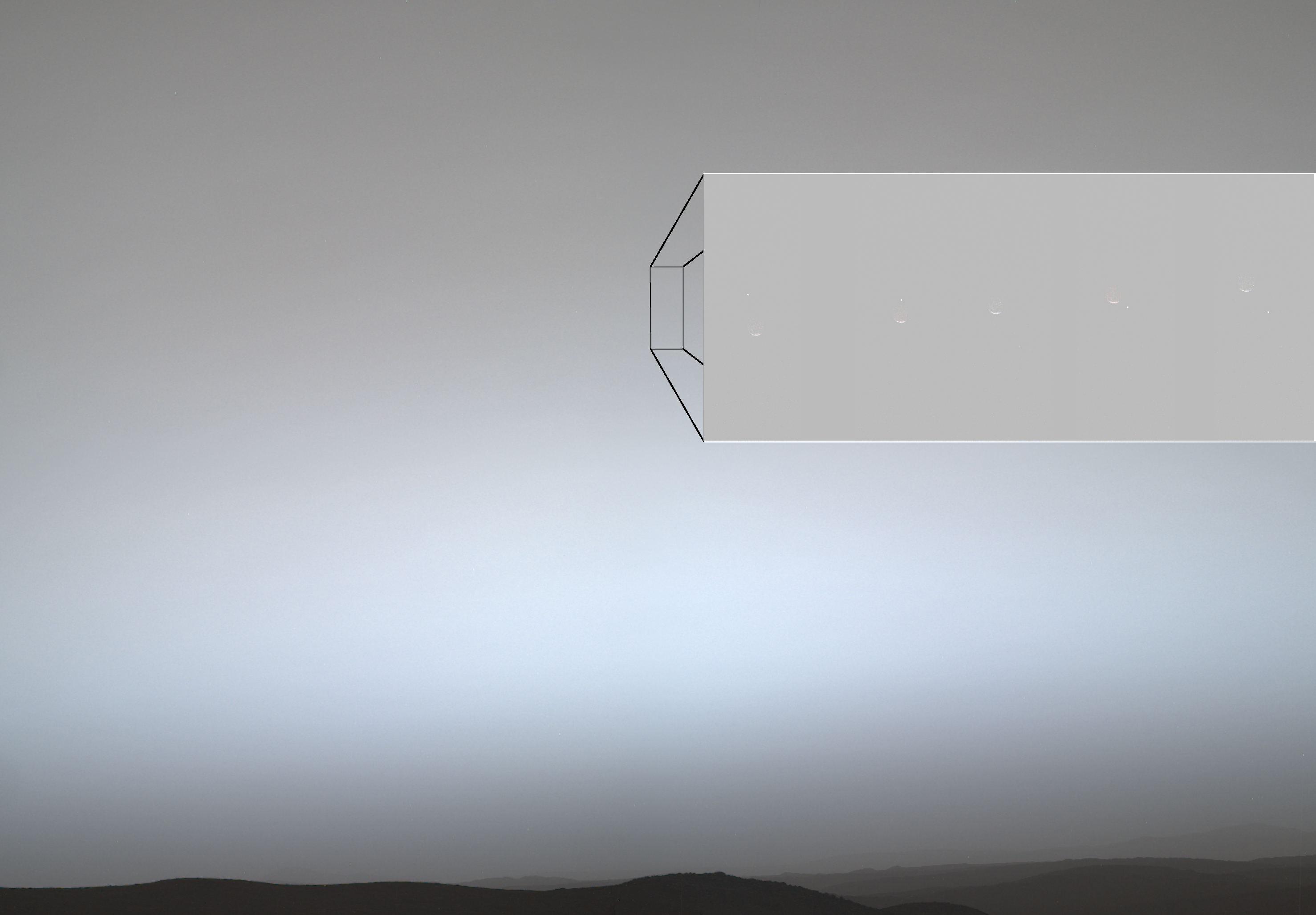
A desolate landscape with a dark horizon sits under a hazy, gray-blue sky. A large rectangular inset in the sky, connected by lines to a smaller rectangle, shows a sequence of five faint crescent shapes with a tiny bright dot moving downward.
Figure A

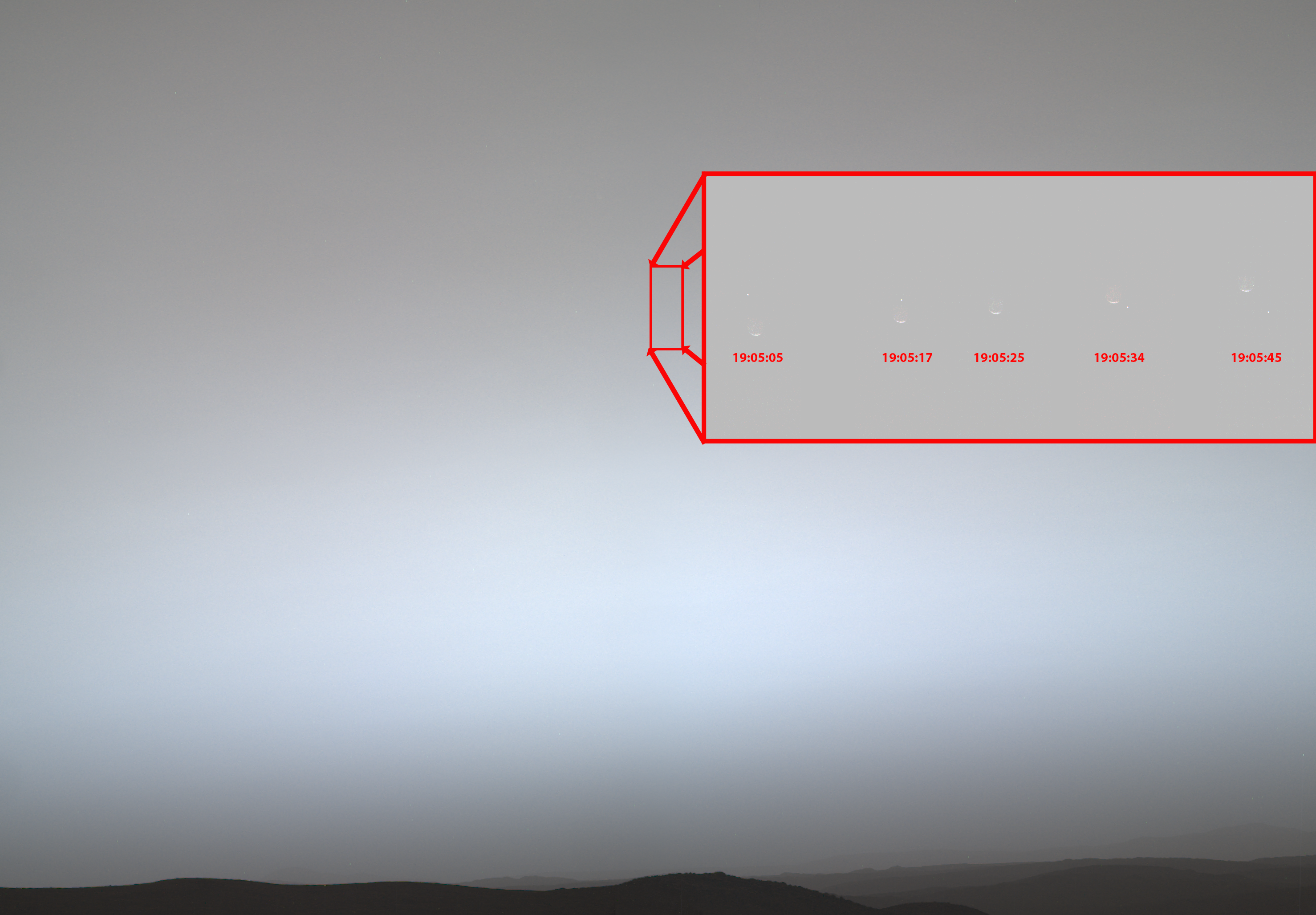
Figure A is an annotated composite of nine images taken by the Mastcam-Z instrument aboard Perseverance on July 2, 2026. The inset on the upper right, comprised of five images, shows Earth — the small bright dot moving from upper left to lower right — passing behind the Martian moon Phobos. 

The rectangle outlined at the left in the annotation indicates the patch of sky that was imaged several times to capture Earth passing behind Phobos. In the larger rectangular inset, the images captured from that patch of sky are displayed in time order from left to right, with Phobos moving up and Earth moving down. 

The gray of the Martian sky is the approximate true color of the twilight (about 40 minutes after sunset) on that sol. It is blue-gray lower, where it is brighter, and reddish gray above.

A dark horizon under a hazy gray-blue sky. A red-outlined rectangular inset, connected by lines to a smaller rectangle, shows five faint crescent shapes with a bright dot moving downward. Timecodes beneath each crescent indicate a span of 40 seconds.
Figure B

Figure B includes annotations showing the local solar time on Mars during which the five individual images that captured the occultation were taken. 

NASA’s Jet Propulsion Laboratory in Southern California, which is managed by Caltech, built and manages operations of the Perseverance rover on behalf of the agency’s Science Mission Directorate in Washington, as part of NASA’s Mars Exploration Program portfolio. Arizona State University leads the operations of the rover’s Mastcam-Z instrument, working in collaboration with Malin Space Science Systems in San Diego, on the design, fabrication, testing, and operation of the cameras.

For more about Perseverance:

science.nasa.gov/mission/mars-2020-perseverance/

❌
❌