❌

Normal view

There are new articles available, click to refresh the page.
Before yesterdayMain stream

Fires Char New Guinea

22 October 2026 at 00:01
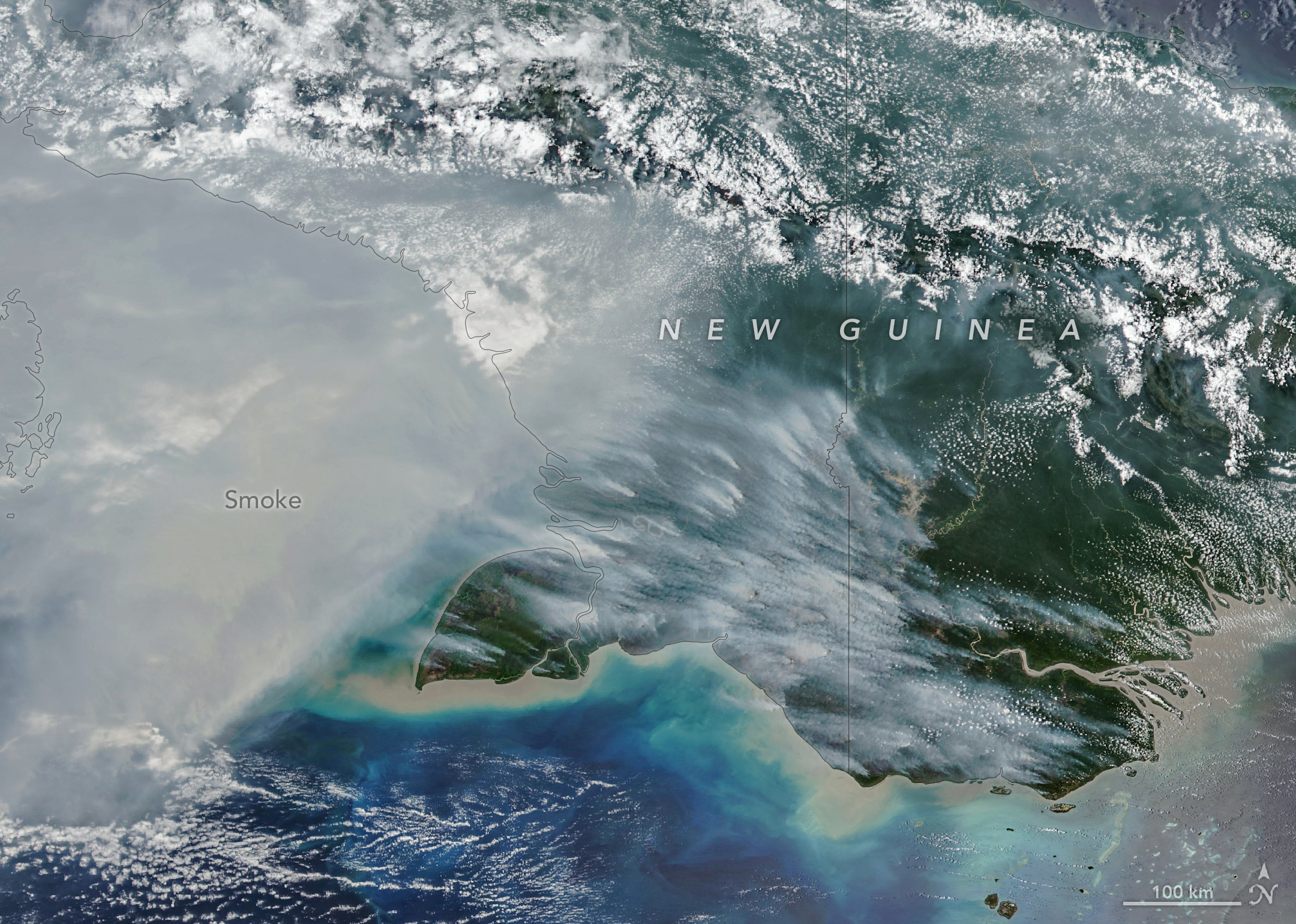
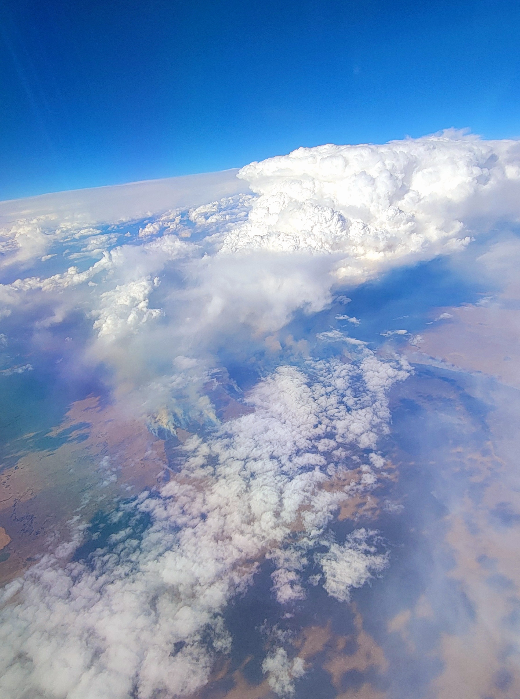
Smoke covers much of the southern third of New Guinea, while clouds and east-west-running mountain ranges are visible in the northern part of the island.

New Guinea, the world’s second-largest island, harbors an extraordinary variety of plant life across more than a dozen distinct ecoregions, including seasonally dry savannas, tropical rainforests, and lowland swamp forests. But in September and October 2026, as drought gripped New Guinea (sometimes called Papua) amid a strong El Niño, fires scorched the island and smoke shrouded large swaths of it for weeks.

The VIIRS (Visible Infrared Imaging Radiometer Suite) on the NOAA-20 satellite captured this image of thick smoke streaming from the southern part of the island on October 11, 2026. In recent weeks, soaring levels of air pollution delayed and canceled flights, closed schools, and prompted officials in some areas to urge children and older people to wear masks.

“Sometimes smoke that has drifted into the convection of nearby thunderstorms will get washed out or lofted up into the upper troposphere, but a lot of smoke stays near the surface and causes air quality problems,” said Robert Field, an associate research scientist at NASA’s Goddard Institute for Space Studies and Columbia University. “It’s a horrible situation.” 
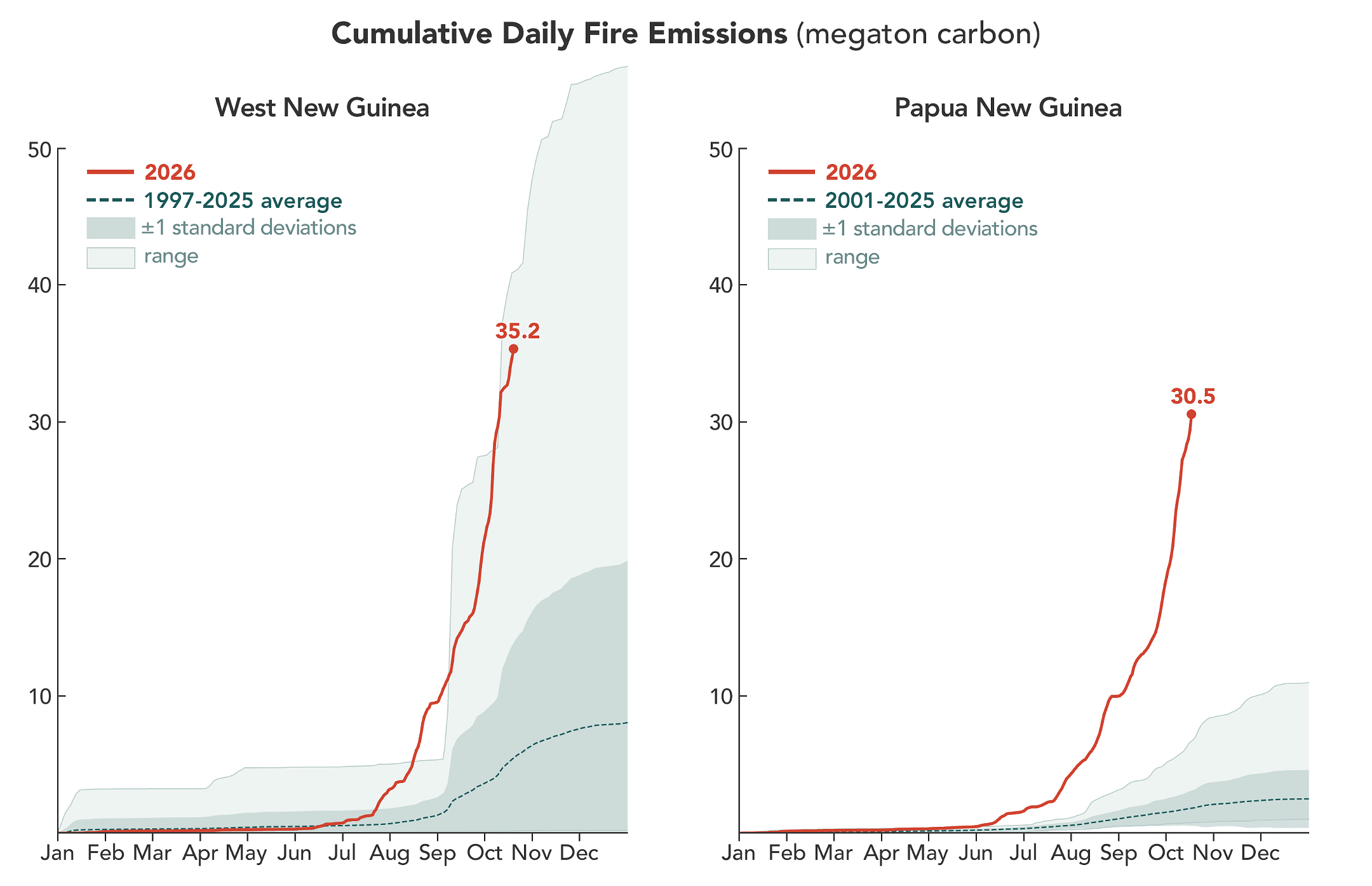
A line chart shows that fires on the Indonesian side of the island have generated more carbon emissions, and at a faster rate, than usual in 2026. By October 17, fires had generated 35.2 megatons of carbon. A line chart shows that carbon emissions from fires in Papua New Guinea rose earlier than usual in 2026, reaching 30.5 megatons of carbon by October 17.

According to the Global Fire Emissions Database (GFED), a fire emissions monitoring system, fires in Papua New Guinea, on the eastern half of the island, had released nearly 32 megatons of carbon by October 17, more than any other year on record at that point in the year (charts above). “Emissions are already much higher than the 2015 total for the year, and it’s very likely that this will become the highest year on record for Papua New Guinea, even surpassing 1997,” said Guido van der Werf, a fire scientist at Wageningen University & Research.

On the Indonesian side, sometimes called West New Guinea or Indonesian Papua, carbon emissions exceeded 35 megatons, the third highest after 2015 and 1997, other El Niño years with severe fires. Van der Werf led the development of GFED, a satellite-driven modeling framework that uses a mix of remote sensing, vegetation characteristics, and other information to estimate the extent of vegetation fires and the emissions over nearly three decades.

Unusually dry weather—a byproduct of El Niño shifting rainfall patterns—has primed ecosystems across the island to burn. The southernmost part of Papua New Guinea, dominated by relatively fire-prone savannas and grasslands of the Trans-Fly region, went more than 90 consecutive days without rain, according to Papua New Guinea’s National Weather Service. Since August, parts of the region have seen precipitation of roughly 5 to 10 percent of normal, according to the weather service’s data. Local news outlets report that drought is causing crop failures, water shortages, and school disruptions.

In this normally wet part of the world, people ignite the vast majority of fires, researchers say. Crop fires, pasture maintenance, deforestation and land clearing, and hunting are all common reasons people burn in New Guinea. In dry conditions, managed fires sometimes spread and burn uncontrolled as wildfires, particularly in the drier, southernmost parts of the island. 

“We’re seeing an exceptionally high level of fire activity in Papua New Guinea and Eastern Indonesia, particularly Indonesian Papua and Kalimantan, this year compared with Sumatra and other parts of Western Indonesia,” said Yang Chen, an associate researcher at the University of California, Irvine. “Papua has emerged as Indonesia’s new deforestation frontier.”

Over the past two decades, land in Indonesian Papua has been cleared for industrial oil palm and pulpwood plantations, shifting small-scale cultivation, urban expansion, and mining. According to Global Forest Watch, the region lost 27,000 hectares of primary forest in 2025, nearly double the 2024 total and the most since 2017.

Sumatra’s fires are relatively low compared to other drought years partly because many areas are already developed. “Areas with large oil palm, sugarcane, or pulpwood plantations also often have their own private fire brigades to protect their assets,” said Field. “It’s in unmanaged areas or primary forest edges where we’re generally seeing the most fire.”

Researchers expect the fires to continue until the heavy rains of the wet season arrive in the southern part of New Guinea, typically in early November.

NASA Earth Observatory image and charts by Michala Garrison, using data from NASA EOSDIS LANCE, GIBS/Worldview, Joint Polar Satellite System (JPSS), and the Global Fire Emissions Database (GFED). Story by Adam Voiland.

Downloads

Smoke covers much of the southern third of New Guinea, while clouds and east-west-running mountain ranges are visible in the northern part of the island.

October 11, 2026

JPEG (2.32 MB)

References & Resources

You may also be interested in:

Stay up-to-date with the latest content from NASA as we explore the universe and discover more about our home planet.

Fires Arrive in the Amazon Rainforest

6 min read

During El Niño, a cascade of fires across the tropics begins in equatorial Asia and continues in the central and…

Article

Peatland Fires Darken Skies in Indonesia

6 min read

With Indonesia gripped by drought, fires are smoldering on the surface and underground.

Article

Smoke Streams Across Eastern Washington

3 min read

Wildland fires in early August 2026 pushed air quality to unhealthy levels, destroyed hundreds of structures, and triggered mandatory evacuations…

Article

Fires Arrive in the Amazon Rainforest

15 October 2026 at 00:01
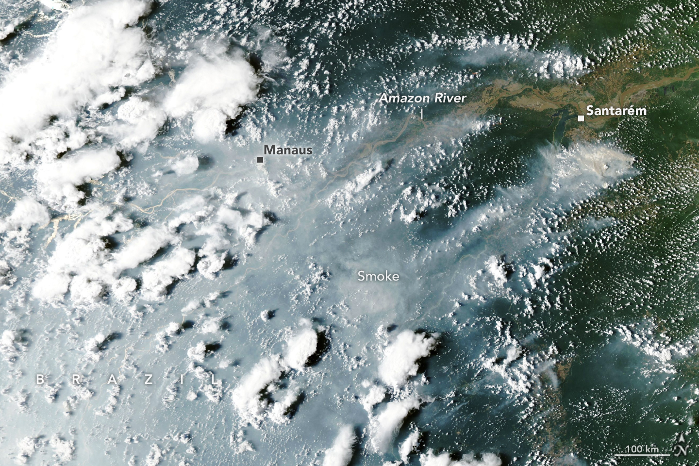
Thick gray smoke partially obscures the Amazon River and surrounding rainforest near the cities of Manaus and Santarém. Puffy white clouds rise above the smoke on the left side of the image.

Unlike a tornado or thunderstorm that can deliver destruction in minutes, El Niño exerts its influence over many months. This year, a drought accompanying El Niño has left the Amazon rainforest primed to burn, and scientists say the region has entered the early stages of what they think will be a long and severe fire season.

Starting in September 2026, satellites detected sharp increases in fire activity and smoke emissions in the central and eastern Amazon, visible in fire and emissions monitoring platforms including NASA’s Fire Information for Resource Management System (FIRMS), the Global Fire Emissions Database (GFED), and NASA Worldview. The region with elevated fire activity stretches from forests surrounding the commercial and transportation centers of Manaus and Santarém to the mouth of the Amazon River.

When the MODIS (Moderate Resolution Imaging Spectroradiometer) on NASA’s Aqua satellite captured this image of smoke streaming from fires on both sides of the Amazon River on October 12, 2026, heavy smoke socked in Manaus, the capital of the Brazilian state of Amazonas. That day, city officials reported extremely poor air quality, with fine particulate matter (PM2.5) values above 135 micrograms per cubic meter, the second-worst rating on a regional air quality index. The pall disrupted daily life in a city of more than 2 million people. Schools closed, and citywide events and children’s sports leagues were canceled as officials warned of hazardous air quality, according to news reports.

The burning around Santarém and Manaus is part of a “cascade” of fire in the tropics that accompanies the disrupted rainfall patterns of an El Niño, said Douglas Morton, an Earth system scientist based at NASA’s Goddard Space Flight Center. The pattern begins along the equator with drought and peat fires in Indonesia, followed by elevated fire activity in this part of the Amazon. Morton and colleagues from the University of California, Irvine; Vrije Universiteit Amsterdam; and the University of Maryland detailed the pattern in a 2017 study following the destructive fire season that accompanied the 2015–2016 El Niño. They also saw the pattern play out in 2023.

A swell of fire in the tropics riding the 2026 El Niño has followed the pattern. Drought, fire, and smoke have smothered parts of Indonesia since August, with hundreds of homes razed in October and thick smoke blanketing whole islands most days. “Now, in the Amazon, we’re seeing the second domino in the cascade fall,” Morton said, referring to the uptick in fires that has begun in Pará and Amazonas.

Morton and his colleagues expect the next wave of fire to hit farther north in November and December in the Brazilian states of Roraima, northern Pará, and Amapá, as well as parts of Venezuela, Guyana, and Suriname. Finally, around August and September 2027, he said, drought and fire risk will peak in the southern Amazon regions of Brazil and Paraguay.

“It’s so striking—and frustrating—that this is happening all over again,” said Morton, adding that many of the same forests that burned during the El Niño events in 2023 and 2015 are burning again. Forest fires in these rainforests are known to cause especially serious ecological damage because most species are not adapted to fire. It’s likely that some of the forest fires will burn even more intensely this time because the earlier fires partially charred trees, degrading the forest and making what remained more susceptible to burning, he added.

Morton expects the fires around Santarém and Manaus to continue burning until the rainy season arrives in December 2026 or January 2027. For the regions to the north and south, there is still time to prepare. “Given the intensity of this El Niño, this really is the year for people to avoid burning at all costs,” Morton said.

It’s so wet in the Brazilian Amazon that lightning ignites less than 1 percent of fires, so the vast majority of fires currently burning there were started by people, Morton said. But this year’s drought, worsened by El Niño, has been intense. Brazil’s National Institute of Meteorology reported that Manaus rainfall levels were 95 percent less than normal in August and 60 percent less than normal in September.

The large fires in this region began as management fires—clearing shrubs from pastures or crops from fields, for instance—but have escaped and are now burning freely through the parched understory of the rainforest, he added. Analysis of satellite observations indicates there are 50 to 70 uncontrolled fires burning in the Santarém region alone, said Shane Coffield, a University of Maryland assistant research scientist at NASA Goddard.

As part of a NASA Earth Action project, Coffield is mining fire observations from VIIRS (Visible Infrared Imaging Radiometer Suite) to identify fires that didn’t meet the threshold for inclusion in official data products distributed by FIRMS. He plans to share the locations of these “candidate fires” with scientists at MapBiomas, a multi-institutional network comprising universities, NGOs, and technology companies that maps fires and land-use change in the Amazon.

“For the area around Santarém, we’ve identified about 40 percent more fires than you’ll see in active fire counts from FIRMS,” said Coffield. Satellites often miss fires in circumstances like this due to dense smoke, clouds, and tree canopy cover, which can block the sensors from detecting the infrared signal of fires—especially lower-intensity fires spreading along the forest understory. “On some of the smokiest days, we have very few detections from MODIS and VIIRS, and we know that isn’t right.”

NASA Earth Observatory images by Lauren Dauphin, using MODIS data from NASA EOSDIS LANCE and GIBS/Worldview. Story by Adam Voiland.

Downloads

Thick gray smoke partially obscures the Amazon River and surrounding rainforest near the cities of Manaus and Santarém. Puffy white clouds rise above the smoke on the left side of the image.

October 12, 2026

JPEG (2.97 MB)

References & Resources

You may also be interested in:

Stay up-to-date with the latest content from NASA as we explore the universe and discover more about our home planet.

Peatland Fires Darken Skies in Indonesia

6 min read

With Indonesia gripped by drought, fires are smoldering on the surface and underground.

Article

Fighting Fire With Fire

3 min read

In fire-prone ecosystems in Australia’s Northern Territory, prescribed burns are lit to minimize the severity of fires later in the…

Article

Smoke Streams Across Eastern Washington

3 min read

Wildland fires in early August 2026 pushed air quality to unhealthy levels, destroyed hundreds of structures, and triggered mandatory evacuations…

Article

NASA Campaign Explores Clouds Spawned by Wildfires

2 October 2026 at 12:34
6 Min Read

NASA Campaign Explores Clouds Spawned by Wildfires

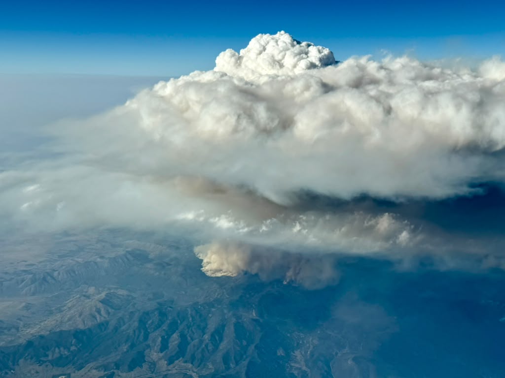
The Wildhorse grass fire in eastern Idaho erupted with a massive pulse of smoke. No one had expected it, but the wildfire had launched what’s known as a pyrocumulonimbus cloud, or pyroCb. It was an elusive weather phenomenon that scientists on NASA’s INSPYRE (INjected Smoke and PYRocumulonimbus Experiment) campaign spent weeks this summer hunting across western North America.

Fire-driven weather about the Widemouth 2 fire in Utah, as seen from the NCAR Gulfstream jet during the fourth INSPYRE campaign research flight on Aug. 3.
INSPYRE/Bernadett Weinzierl

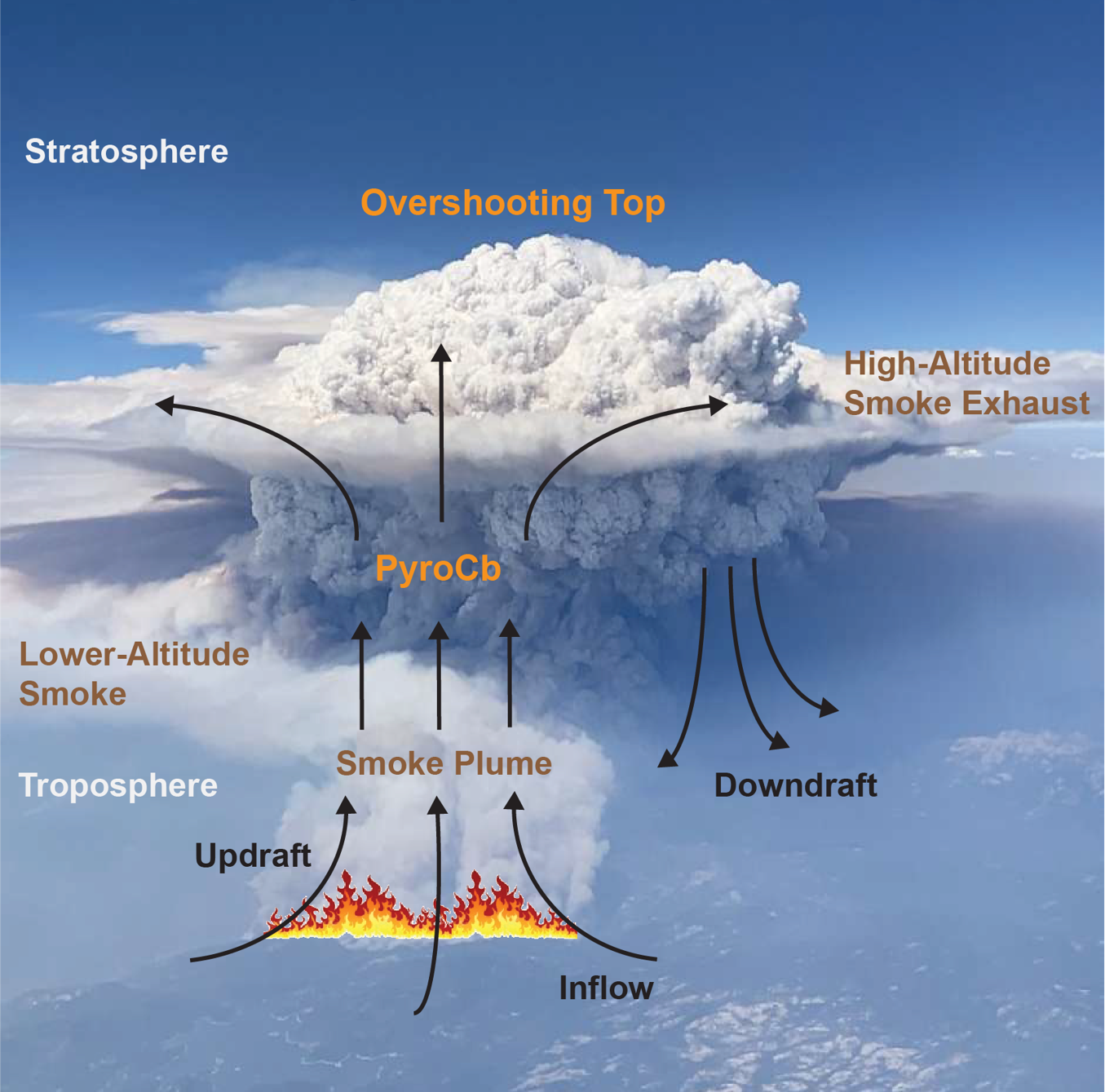
Pyrocumulonimbus clouds rise above intense fires, producing lightning and rain along with powerful winds that can whip the flames below into a fury. The largest pyroCbs funnel smoke 30,000 to 50,000 feet (10 to 15 kilometers) above Earth’s surface, as high as the cruising altitudes of commercial jets and even into the stratosphere.

A pyroCb cloud forms when an intense fire funnels a chimney of smoke into the stratosphere above the height of most clouds formed by normal weather patterns.
NASA/Bill Ingalls, NASA/JSC/Mark Sowa

The significance of pyroCbs emerged around the turn of the 21st century, when satellite observations revealed smoke reaching altitudes previously associated with major volcanic eruptions. Once in the stratosphere, pyroCb smoke can spread across continents, circle the globe, and persist far longer than it would in the lower atmosphere.

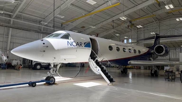
The NCAR Gulfstream jet, outfitted with instrumentation for studying clouds and smoke over wildfires, sits in its hangar at the National Science Foundation’s NCAR Research Aviation Facility in Broomfield, Colorado.
NASA/Bill Ingalls, NASA/JSC/Mark Sowa

Despite their massive size, pyroCb clouds remain mysterious. But it’s important to understand how they form and connect with the atmosphere, because their smoke can affect climate and weather far from the fires that produced them and long after they’ve extinguished. They also can produce dangerous fire-generated winds.

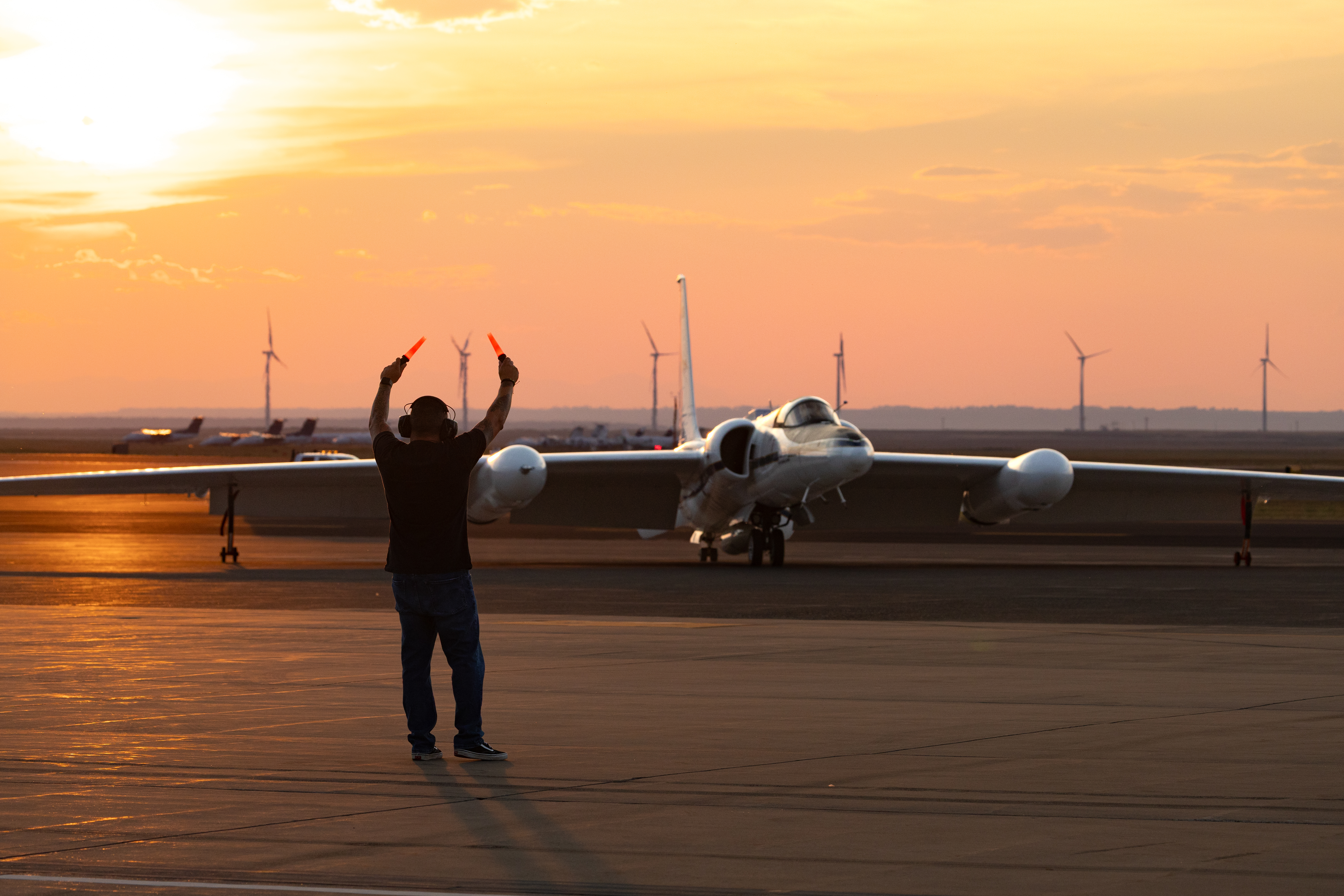
NASA’s ER-2 taxis on the runway during its deployment at the Great Falls International Airport. The high-flying jet launched from Great Falls, Montana, on flights across western North America and as far north as Alaska during the INSPYRE campaign.
NASA/Milan Loiacono

“We still do not understand if they’re driven by fire energetics, or fire intensity, or by atmospheric conditions above,” said Olga Kalashnikova, a researcher with NASA’s Jet Propulsion Laboratory in Southern California, who is one of the principal investigators leading INSPYRE, the first aircraft campaign designed specifically around studying pyroCbs.

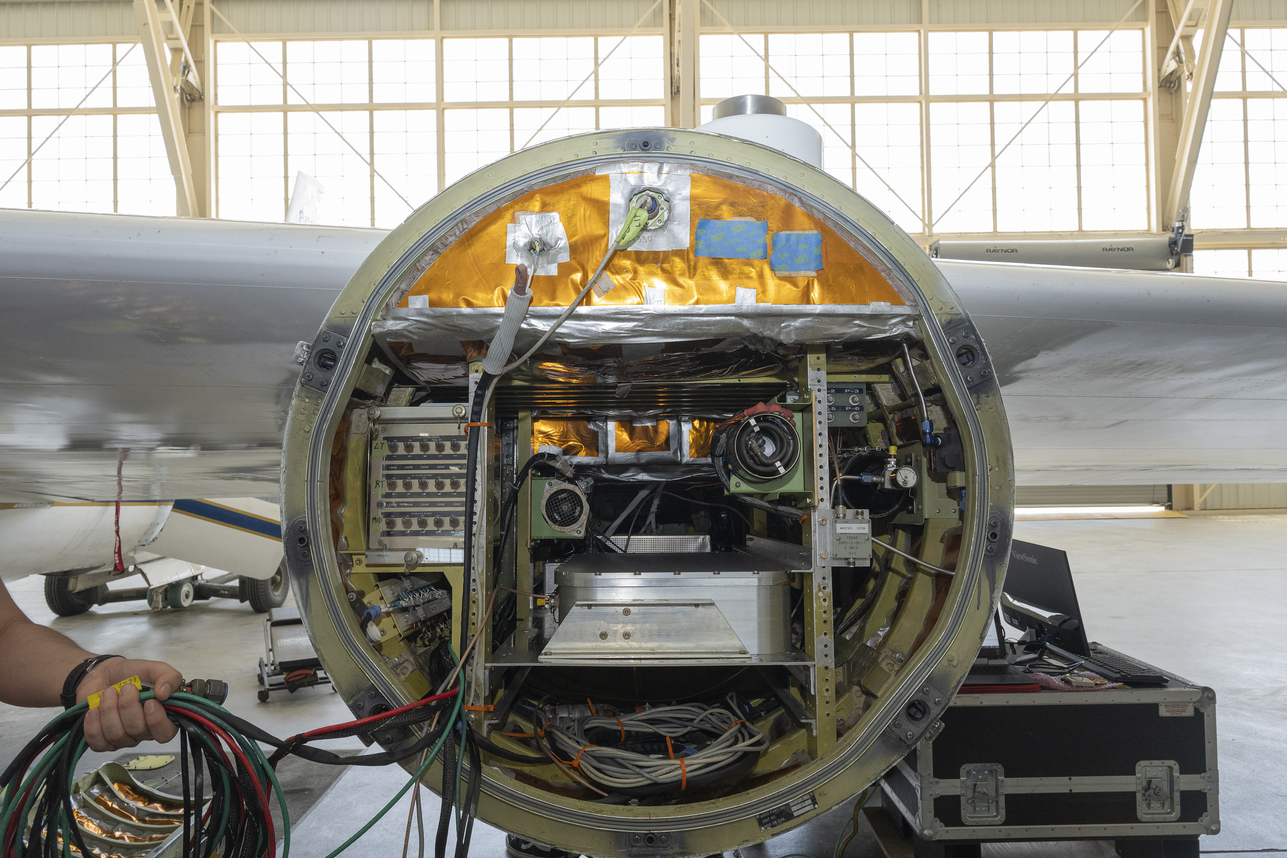
Front view of an open instrument pod mounted beneath a NASA ER‑2 aircraft, showing cables, sensors, and electronic equipment arranged inside a circular housing. A person’s hand holding a bundle of cables is visible on the left side, with the aircraft hangar visible in the background.
An ER‑2 aircraft based at NASA’s Armstrong Flight Research Center in Edwards, California, carries a pod full of instruments for the INSPYRE campaign.
NASA/Carla Escamilla

For six weeks this summer, INSPYRE researchers climbed aboard a Gulfstream jet for a series of flights from the plane’s home base at the National Center for Atmospheric Research (NCAR) near Boulder, Colorado. Scientists collected smoke particles, sampled gases, photographed ice crystals, and monitored radiation passing through clouds and reflected back into space. The aircraft crisscrossed above, below, and through clouds to get a close-up view of fire-induced weather and smoke.

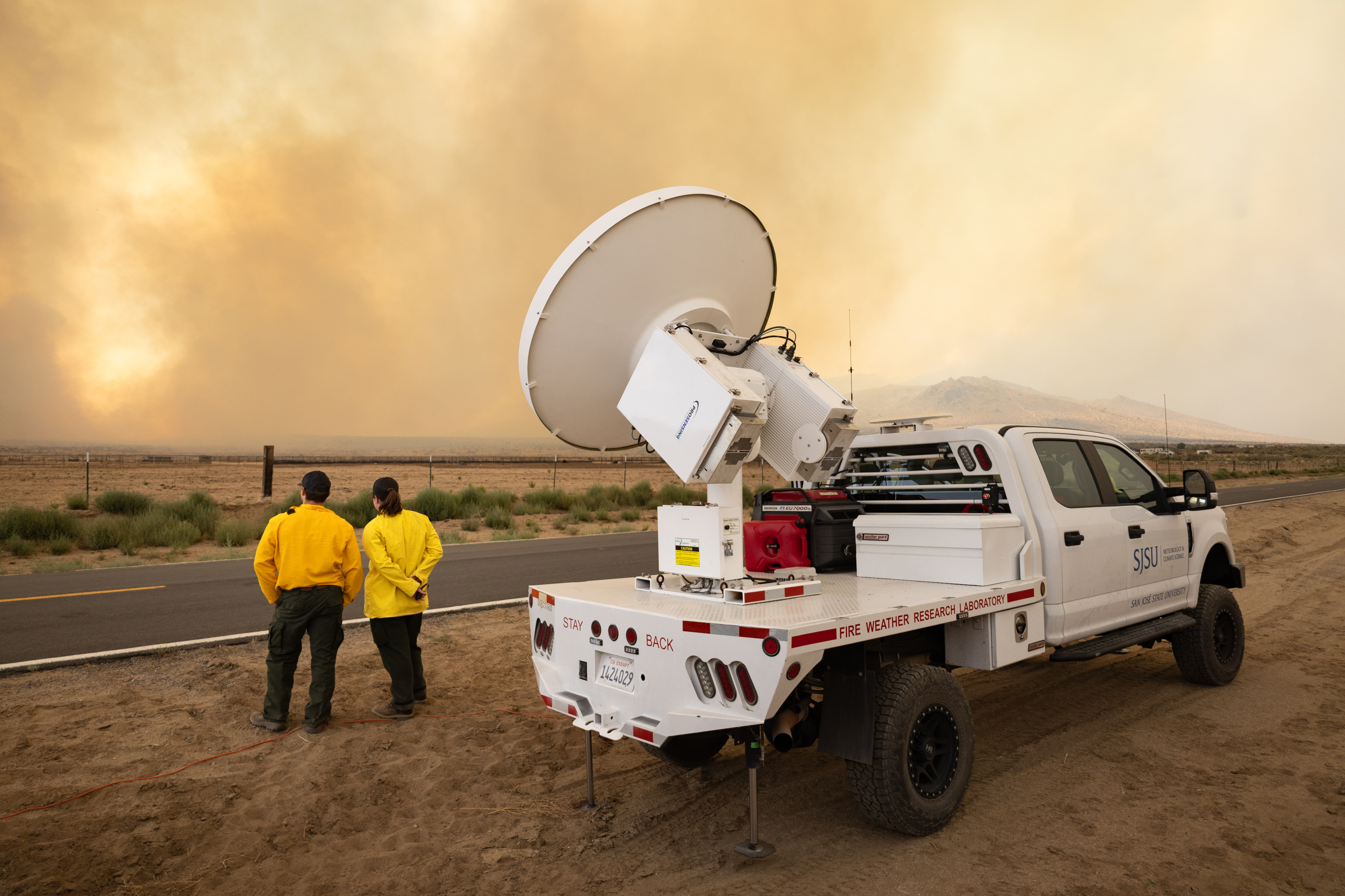
Meanwhile, NASA’s high-flying ER-2 aircraft, loaded with 14 instruments, tracked fire intensity, updraft speeds, smoke, and cloud properties from above, while crews drove trucks equipped with sensors to view the same events from the ground. Ultimately, the team will investigate how wildfire-generated clouds transport smoke upward, how clouds transform particles and gases in smoke, how much reaches the stratosphere, and what happens once it gets there.

From fire forecasts to climate models

Firefighters will benefit from a better understanding of when pyroCbs are likely to develop and how they affect fire conditions on the ground. “A unique thing about pyrocumulonimbus is they are fire-generated weather, meaning the fire makes its own weather,” said Neil Lareau, an atmospheric scientist at the University of Nevada, Reno, who led INSPYRE’s ground observations. “The fire is making its own thunderstorm, and in the process of doing that, it’s also making its own wind.”

A unique thing about pyrocumulonimbus is they are fire-generated weather . . . the fire makes its own weather.

Neil Lareau

University of Nevada

Lareau hopes the research will lead to warnings comparable to the alerts meteorologists issue for severe thunderstorms. For example, he said, a forecast would warn firefighters that a developing cloud could soon produce a dangerous downdraft and wind shift, giving fire managers time to pull personnel off the line.

Ground crews traveled across the western U.S. to monitor wildfires up close during the INSPYRE campaign.
NASA/Milan Loiacono

Additionally, INSPYRE could also improve Earth system models. PyroCbs can carry enormous quantities of smoke into the stratosphere, where particles can persist for months or longer and affect how much solar energy the atmosphere absorbs and how much reaches Earth’s surface. Most numerical prediction models don’t explicitly include the effects of pyroCbs and their smoke injections, said Dave Peterson, a Naval Research Laboratory meteorologist and INSPYRE’s co-principal investigator. Measurements of the particles, gases, and radiation associated with these events will give scientists data to test and improve simulations of their effects on Earth’s weather and climate.

Hunting storms

To study wildfire smoke and clouds, and perhaps catch a pyroCb in action, the INSPYRE team first had to find one. The challenge was getting an aircraft to the right place at the right time. Pyrocumulonimbus clouds can develop in minutes and subside just as quickly, while reaching fires hundreds of miles away takes hours of preparation, flight time, and coordination with air traffic controllers.

Instrumentation racks take the place of passenger seats on the NCAR Gulfstream plane that has been converted from an executive jet to a flying laboratory.
NASA/Katie Jepson

But on Aug. 26, the team got lucky. The Gulfstream was returning from a fire farther west when Sarah Woods, a National Center for Atmospheric Research scientist serving as spotter, got word that the Wildhorse fire was unexpectedly intense.

The fire hadn’t initially attracted much attention. “We knew there was a grass fire there, and everyone’s like, it’s just a grass fire; we’re not going to worry about it,” Peterson said. “And it ended up being the main event.”

We knew there was a grass fire there, and everyone’s like, it’s just a grass fire; we’re not going to worry about it . . . And it ended up being the main event.”

DAVE PETERSON

Naval Research Laboratory

When the flight path neared the Wildhorse fire, Woods spotted the fresh remains of a pyroCb from her cramped jump seat behind the pilots. “It looks just like a big thunderstorm, and so as you approach it, you look for a visual indication of the fire on the ground,” said Woods.

Researchers on an Aug. 26 INSPYRE research flight encountered a pyrocumulonimbus (pyroCb) cloud that unexpectedly formed over the Wildhorse grass fire in eastern Idaho.
INSPYRE/Chris Kruse

Seeing the fire on the ground far below confirmed that the cloud was fire-generated. At Woods’ request, the pilots swung the plane around and spent the next three hours flying back and forth through the cloud plume and the trail of smoke drifting northwest toward Wyoming.

The chance encounter gave the INSPYRE team measurements of a pyroCb plume roughly an hour after the cloud first erupted. Other flights coordinated between the Gulfstream jet and ER-2 added crucial observations of active fire-driven atmospheric airflow that will help document how the resulting smoke plumes evolve over the days and weeks that follow.

Putting pieces together

Measurements from the Gulfstream and ER-2 will now be combined with satellite and ground observations and compared with models.

“When clouds form, they modify chemistry,” said Kalashnikova, the JPL-based principal investigator. That altered smoke can have different effects on radiation, she said, making it important to understand both how pyroCbs form and the smoke that emerges from them.

In the summer of 2026, the challenge was finding the clouds and collecting the measurements. Now comes the work of understanding what they found.

About the Author

James Riordon

James Riordon

Senior Science Writer

Keep Exploring

Discover More Topics From NASA

Fire Cloud with a Pileus on Top

29 September 2026 at 00:01
natural color
swir
Natural-color aerial image of a wildfire in mountainous terrain. Thick gray and brown smoke spreads across much of the landscape, while a towering white pyrocumulus cloud rises at right. A smooth, thin pileus cloud hovers just below the main convective cloud.
NASA Earth Observatory/Michala Garrison
False-color aerial image of the same wildfire. Active fire fronts appear bright pink, magenta, and yellow around a large brown burned area. A towering white pyrocumulus cloud rises from the fire at right. A smooth, thin pileus cloud obscures part of its top.
natural color
swir
A pileus cloud veils part of a pyrocumulus rising from the Sand Creek fire in Montana on August 11, 2026, in images captured by the MASTER (MODIS/ASTER Airborne Simulator) on NASA’s ER-2. In the false-color image (right) active fires appear pink and yellow, burned areas brown, clouds white, and smoke blue-purple. MASTER images by RoseAnne Dominguez, annotated by Michala Garrison.

In summer 2026, scientists took to the air to intercept and study the towering, smoke-infused clouds that wildland fires sometimes create. But during an August 11 flight over the Sand Creek fire in Montana, they came back with a bonus—observations of an ephemeral pileus cloud hovering atop one of the towering fire clouds.

Smooth, veil-like pileus clouds are well-known to atmospheric scientists and cloud lovers and regarded as signs of especially vigorous convection. But researchers rarely observe a pileus cloud interacting with a fire cloud—known as a pyrocumulus (pyroCu)—in as much detail as they did on this flight, part of NASA’s INSPYRE (Injected Smoke and Pyrocumulonimbus Experiment) campaign.

Named after the Latin for “cap,” pileus clouds typically form when rising columns of air collide with a sufficiently moist layer of air aloft. Over the Sand Creek fire, a fast-rising updraft heated by the fire displaced air vertically and forced a horizontal layer of moister air sitting above it upward. The process is similar to how air forced over a mountain can produce clouds, explained Neil Lareau, INSPYRE’s deputy project investigator. “But in this case, the pyrocumulus itself was the ‘mountain,’” he said. As the displaced air was pushed upward, it cooled, and its water vapor condensed into a pileus cloud.

The pair of images above was captured at 5:40 p.m. local time (23:40 UTC) by the MASTER (MODIS/ASTER Airborne Simulator) on one of NASA’s ER-2s, a type of high-flying research aircraft. The natural-color image on the left shows the thin, circular pileus atop the turret of smoke and water rising from the spreading wildfire. The image on the right shows the same moment but includes shortwave-infrared (SWIR) observations, which reveal the burned area and actively burning spots along the fire’s perimeter.   

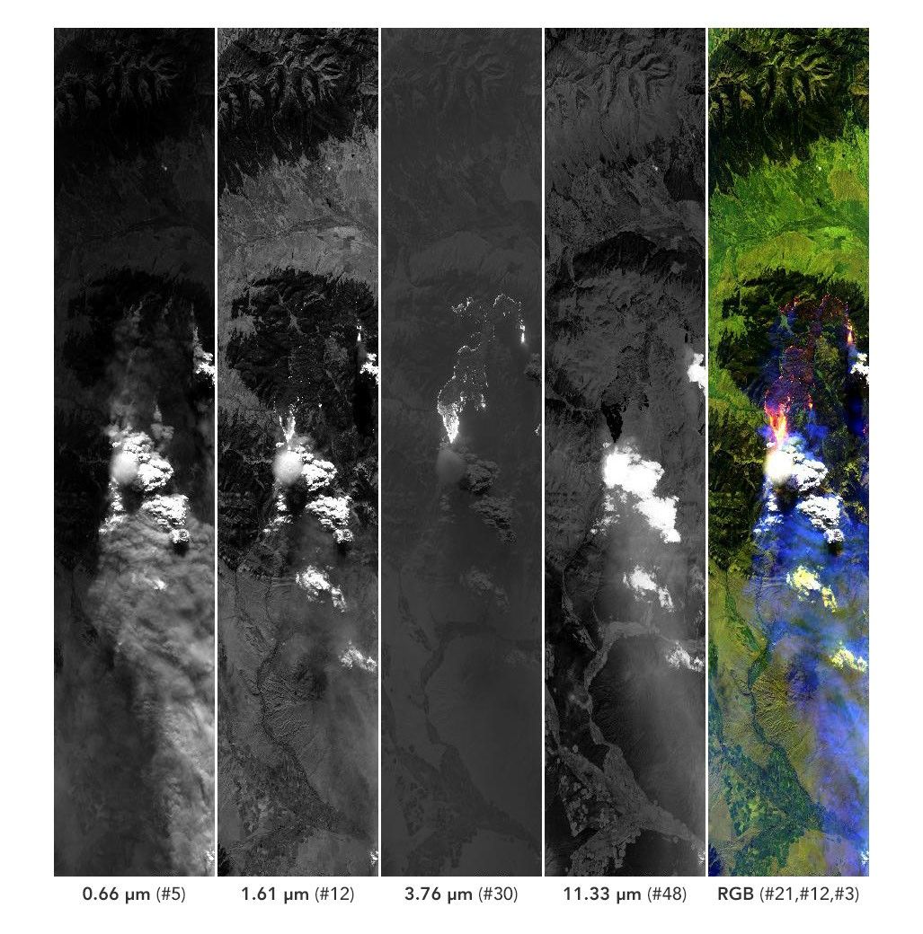
Five side-by-side panels from the MASTER instrument show a wildfire and its smoke plume. The four left panels are grayscale views of the scene at progressively longer wavelengths. The rightmost panel is a false-color composite in which active fires appear pink and yellow, burned areas in purple, smoke in purple, and clouds in white.
MASTER captures data at 50 different spectral bands, including at wavelengths of 0.66, 1.61, 3.76, and 11.33 micrometers. The strip on the far right combines information from three spectral bands.
MASTER/RoseAnne Dominguez.

Pileus clouds are usually quite short-lived, often persisting for only a few minutes before being overtaken by the underlying convection. During this flight, the scientists collected MASTER imagery of the plume roughly every 30 minutes, and the pileus was clearly visible in just one scene. The presence of the cloud hints at what Lareau described as the “extreme updraft dynamics” within the fire plume and pyrocumulus. At the time of the image, he explained, the fire was making a rapid run up the western side of Mount Comet as winds aligned with the drainage channels leading up the mountain.

“The whole scene is amazing,” he said, noting that the science team was fortunate that MASTER’s visible channels captured the rapidly developing pyrocumulus and pileus cloud, its infrared channels captured the fire’s extreme surface behavior, and downward-pointing radars on the airplane studied the cloud structure. “This scene is in many ways the core of what we’re after with INSPYRE,” he said. “We were able to connect and map the surface fire dynamics to the convective plume to the cloud processes.” The image above shows the cloud in four of the 50 channels, or bands, measured by MASTER. The false-color panel on the far right of the image is a combination of shortwave-infrared and visible observations, similar to the right image at the top of the page.

Fires are just one driver of convection that can produce pileus clouds. Vigorous updrafts associated with severe thunderstorms can also produce these wispy clouds. Researchers who participated in NASA’s CRYSTAL-FACE (Cirrus Regional Study of Tropical Anvils and Cirrus Layers-Florida Area Cirrus Experiment) in Honduras in 2002 reported the presence of thin cirrus clouds in the tropopause above thunderstorms that were likely the products of pileus clouds.

Volcanic eruptions can produce pileus clouds as well. One of the more stunning images captured by astronauts and published by NASA Earth Observatory is this photograph of a pileus cloud cloaking the top of a volcanic plume rising from the Sarychev volcano after an eruption in 2009.

MASTER images by RoseAnne Dominguez (Airborne Sensor Facility), annotated by Michala Garrison. Story by Adam Voiland.

Downloads

Natural-color aerial image of a wildfire in mountainous terrain. Thick gray and brown smoke spreads across much of the landscape, while a towering white pyrocumulus cloud rises at right. A smooth, thin pileus cloud hovers just below the main convective cloud.

August 11, 2026: Natural color

JPEG (1.08 MB)

False-color aerial image of the same wildfire. Active fire fronts appear bright pink, magenta, and yellow around a large brown burned area. A towering white pyrocumulus cloud rises from the fire at right. A smooth, thin pileus cloud obscures part of its top.

August 11, 2026: SWIR

JPEG (2.18 MB)

Five side-by-side panels from the MASTER instrument show a wildfire and its smoke plume. The four left panels are grayscale views of the scene at progressively longer wavelengths. The rightmost panel is a false-color composite in which active fires appear pink and yellow, burned areas in purple, smoke in purple, and clouds in white.

August 11, 2026: Spectral bands

JPEG (570.68 KB)

References & Resources

You may also be interested in:

Stay up-to-date with the latest content from NASA as we explore the universe and discover more about our home planet.

Chasing Fire Clouds in Utah
6 min read

NASA aircraft are sampling smoke lofted high into the atmosphere by one of the most formidable cloud types in the…

Article
Smoke Streams Across Eastern Washington
3 min read

Wildland fires in early August 2026 pushed air quality to unhealthy levels, destroyed hundreds of structures, and triggered mandatory evacuations…

Article
Cottonwood Fire Chars Utah
5 min read

The blaze burned more than 150 square miles and swept through parts of a ski resort.

Article
❌
❌