Normal view

There are new articles available, click to refresh the page.
Before yesterdayMain stream

Anak Krakatau Rumbles Again

9 September 2026 at 00:01
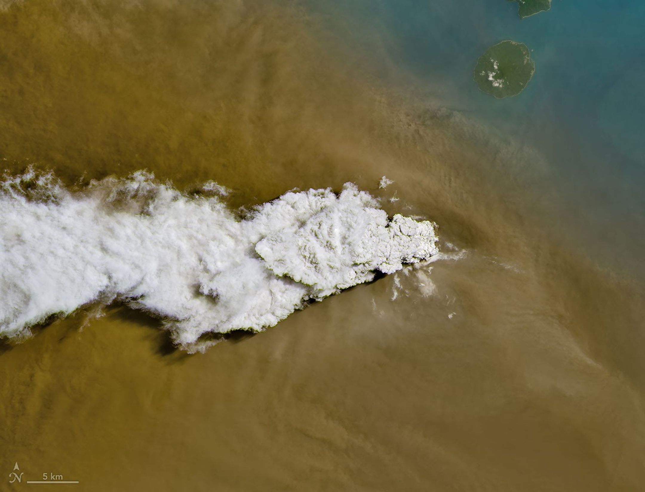
A white volcanic plume streams left over a tan ash cloud that fills most of the image. A small green island and blue water are visible in the upper right.
Anak Krakatau erupts ash and volcanic gases in this image acquired with the OLI (Operational Land Imager) on Landsat 8 on September 5, 2026.
NASA Earth Observatory/Michala Garrison

Eruptions are a regular occurrence at Anak Krakatau, a small volcano between the Indonesian islands of Java and Sumatra. Much of its activity remains relatively mild, but it occasionally puts on more impressive and hazardous shows of force. In early September 2026, a booming eruption lasting more than 24 hours sent gas and ash high into the atmosphere, disrupting thousands of flights and degrading air quality in parts of the country, including the capital city of Jakarta.

Satellites passing over the area during the eruption on September 5 captured images of the explosive activity. In the scene above, acquired with the OLI (Operational Land Imager) on the NASA-USGS Landsat 8 satellite, a white plume of volcanic gas billows over a brown ash cloud. Below, a wider view captured by the VIIRS (Visible Infrared Imaging Radiometer Suite) on the Suomi NPP satellite shows the volcanic material dispersing over a large area.

Indonesia’s meteorological agency reported that ash had reached altitudes up to 6,000 meters (20,000 feet) to the east of the volcano and 15,000 meters (50,000 feet) to the west by September 6. The presence of ash in the atmosphere prompted the temporary closure of eight airports on Java and Sumatra, disrupting nearly 3,000 flights in and out of the area, according to news reports.
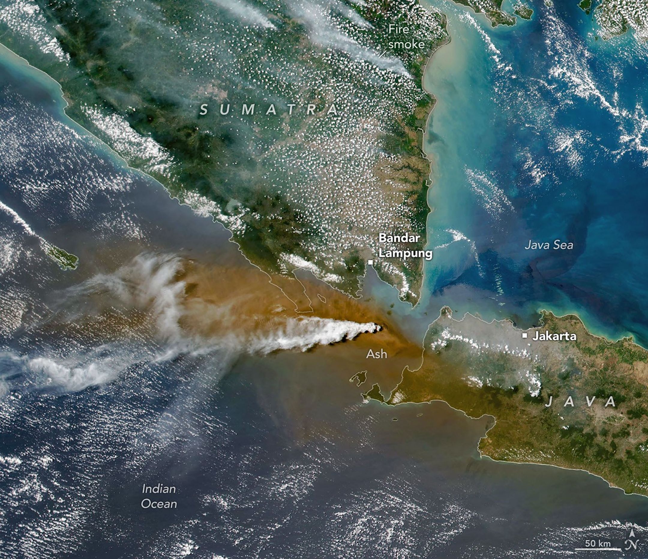
A white plume streams to the left over a larger tan ash cloud, both coming from a volcanic eruption between the Indonesian islands of Java and Sumatra.
Plumes of ash and volcanic gases from Anak Krakatau drift over Indonesia and the Indian Ocean in this image captured by the VIIRS (Visible Infrared Imaging Radiometer Suite) on the Suomi NPP satellite on September 5, 2026.
NASA Earth Observatory/Michala Garrison

Ashfall affected populated areas, particularly to the east of Anak Krakatau in Jakarta and other parts of West Java, the Indonesian Humanitarian Coordination Platform (IHCP) reported. Volcanic ash poses health risks to people and can irritate the respiratory tract, eyes, and skin. However, this air quality hazard differs from the smoke produced by peatland fires elsewhere in the country in terms of particle characteristics, dispersal patterns, and protection measures, the IHCP noted. 

On September 6, the continuous explosive eruption from Anak Krakatau subsided, though the volcano kept rumbling. It returned to a more typical pattern of Strombolian eruptions, characterized by intermittent spurts of ash and volcanic material. Airports had resumed operation by September 8, but the volcano remained at the second-highest alert level on the country’s scale, as it has been since early July.

NASA Earth Observatory images by Michala Garrison, using Landsat data from the U.S. Geological Survey, and VIIRS data from NASA EOSDIS LANCEGIBS/Worldview, and the Suomi National Polar-orbiting Partnership. Story by Lindsey Doermann.

Downloads

A white volcanic plume streams left over a tan ash cloud that fills most of the image. A small green island and blue water are visible in the upper right.

September 5, 2026: Landsat

JPEG (14.89 MB)

A white plume streams to the left over a larger tan ash cloud, both coming from a volcanic eruption between the Indonesian islands of Java and Sumatra.

September 5, 2026: VIIRS

JPEG (3.38 MB)

References & Resources

You may also be interested in:

Stay up-to-date with the latest content from NASA as we explore the universe and discover more about our home planet.

Ever Restless Mount Dukono Erupts

2 min read

The volcano on Indonesia’s Halmahera Island routinely ejects ash, volcanic gases, and volcanic bombs.

Article

New Eruption in the Bismarck Sea

5 min read

Satellite imagery shows a surge of new volcanic activity in the ocean near Papua New Guinea.

Article

Melting Snow Off Shivelyuch

4 min read

Near-constant activity continues on the volcano in Russia.

Article

A Bright Spot at Mount Michael

7 September 2026 at 00:01
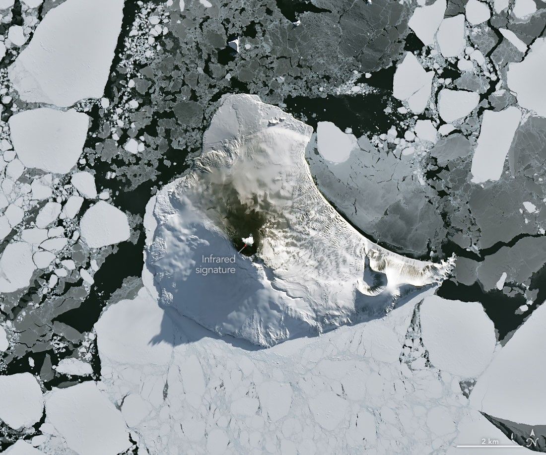
A small ice- and snow-covered island with an active volcanic crater at its center is surrounded by drifting pieces of sea ice. A thermal signal and small plume appear in the crater, and ash darkens the snow on the volcano’s northern slopes.
Mount Michael on Saunders Island, seen in this image acquired with the OLI (Operational Land Imager) on Landsat 8 on August 24, 2026, hosts a frequently active lava lake in its summit crater.
NASA Earth Observatory/Michala Garrison

Winter near the Antarctic Circle brings months of frozen darkness, when sea ice chokes ocean waters and many of its denizens hunker down to ride out the harsh conditions. But as winter began to release its icy grip, an uncommonly clear satellite image revealed that part of this remote realm was still very much awake, at least volcanically speaking.

Mount Michael, the stratovolcano at the center of Saunders Island, rises above the ice-filled South Atlantic Ocean in this image, acquired with the OLI (Operational Land Imager) on the NASA-USGS Landsat 8 satellite on August 24, 2026. The natural-color image is overlaid with an infrared signal (OLI bands 7-6-5), shown in red, revealing heat from the persistent lava lake in its summit crater. A puff of a volcanic plume hovering over the peak, along with darkened snow on its northern slopes, also suggests ongoing activity.

Saunders Island is one of the South Sandwich Islands, a string of small volcanic peaks about 350 kilometers (220 miles) long that formed from the South American plate subducting beneath the tiny South Sandwich plate. Regular eruptions, including at Mount Michael, have occurred on these islands in recent centuries.

Because of the volcanoes’ remoteness, scientists rely on satellite data to understand their activity. An analysis of thermal anomalies in Landsat, Sentinel, and ASTER (Advanced Spaceborne Thermal Emission and Reflection Radiometer) observations spanning 30 years led researchers to conclude that Mount Michael hosts a persistent lava lake in its summit crater. Only a handful of other volcanoes on Earth, including Kīlauea, Nyamulagira, and Erta Ale, are known to have similar, frequently active features.

Thermal observations from the MODIS (Moderate Resolution Imaging Spectroradiometer) and VIIRS (Visible Infrared Imaging Radiometer Suite) instruments have also enabled long-term monitoring of Mount Michael. Data provided through MIROVA, a near-real-time volcanic hot spot detection system, indicate that low-intensity activity has been ongoing at the volcano for the past several years. Other observations from NASA’s Aura satellite show that emissions of sulfur dioxide and other gases are common at Mount Michael.

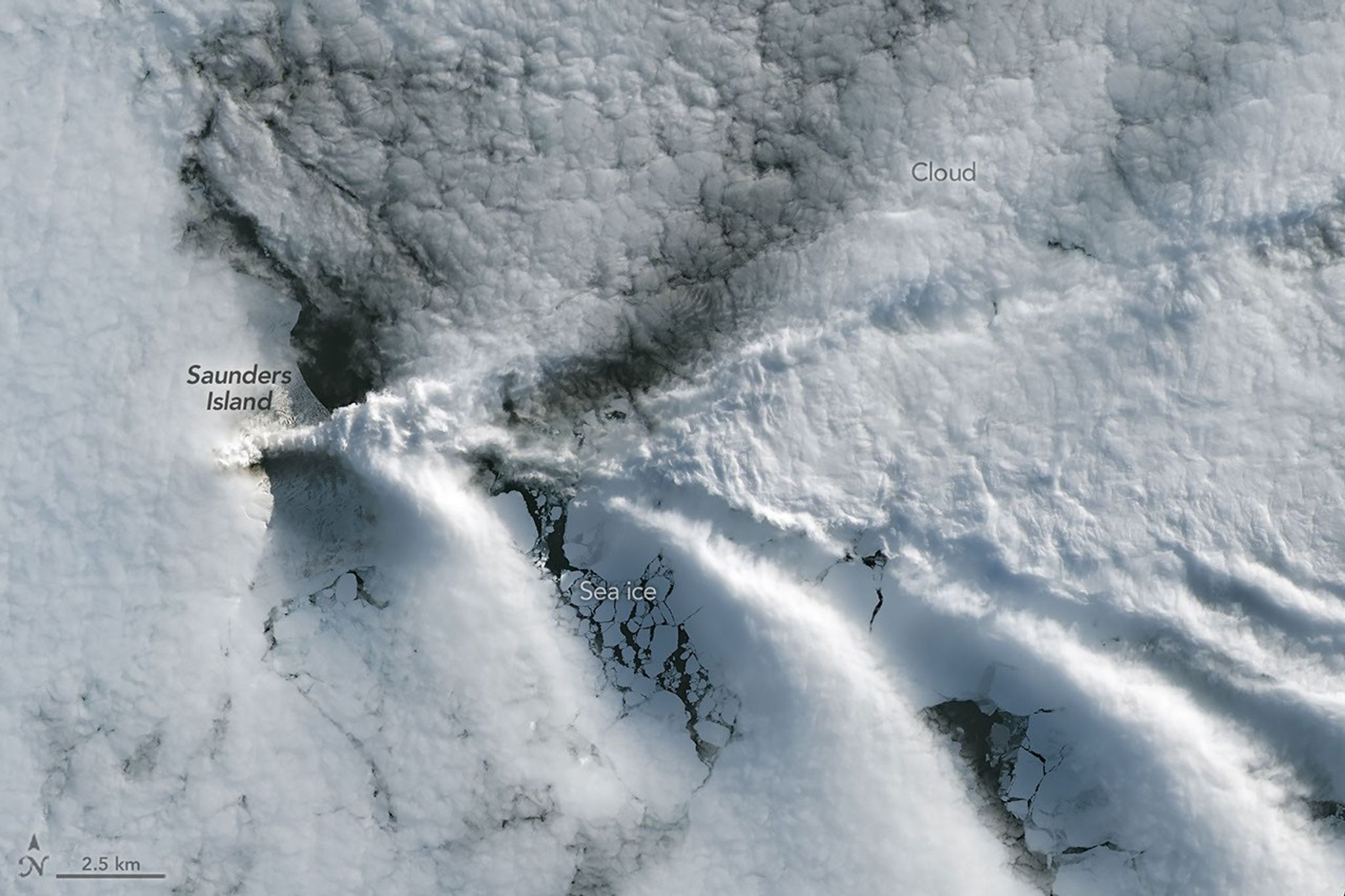
A series of V-shaped wave clouds appears over an ocean filled with pieces of sea ice.
Wave clouds form downwind of Saunders Island in this image acquired with the OLI (Operational Land Imager) on Landsat 9 on September 1, 2026.
NASA Earth Observatory/Michala Garrison

The cloud-free window over Mount Michael would close in short order. One week later, when Landsat 9 passed over the island, a more active atmosphere had returned. But the weather patterns interacted with the island to put on a spectacle of their own. The 843-meter-high (2,766-foot-high) peak jutting from the ocean disturbed passing winds to produce a series of wave clouds resembling the wake of a ship, a familiar phenomenon in this region. False-color imagery captured by NASA’s Aqua satellite indicates that a volcanic track caused by degassing sulfur dioxide was likely present as well.

NASA Earth Observatory images by Michala Garrison, using Landsat data from the U.S. Geological Survey. Story by Lindsey Doermann.

Downloads

A small ice- and snow-covered island with an active volcanic crater at its center is surrounded by drifting pieces of sea ice. A thermal signal and small plume appear in the crater, and ash darkens the snow on the volcano’s northern slopes.

August 24, 2026

JPEG (4.27 MB)

A series of V-shaped wave clouds appears over an ocean filled with pieces of sea ice.

September 1, 2026

JPEG (1.14 MB)

References & Resources

You may also be interested in:

Stay up-to-date with the latest content from NASA as we explore the universe and discover more about our home planet.

Ever Restless Mount Dukono Erupts

2 min read

The volcano on Indonesia’s Halmahera Island routinely ejects ash, volcanic gases, and volcanic bombs.

Article

A Sea of Spinning Clouds

3 min read

Icy, isolated Peter I Island stirred up a show in the atmosphere off the West Antarctic coast.

Article

America’s Emerald Isle

3 min read

Beaver Island is one in a string of verdant and scenic jewels in a northern Lake Michigan archipelago.

Article

Volcanoes that made history

The first telegram arrived in Singapore on a Monday, sent from the city of Batavia in the Dutch East Indies (now Jakarta, Indonesia). “Terrific detonations from Krakatau (volcanic island),” it reported. Soon afterward: “Stones falling. Village near Anjer washed away.” The wires continued clattering out news of bridges destroyed, boats smashed, lighthouses “disappeared.” By noon on Tuesday, the scope of the natural disaster was clear: “Where once Mount Krakatau stood the sea now plays.”

Within days, the source of the destruction was known worldwide. On the morning of August 27, 1883, a volcanic eruption had obliterated two islands in the strait between Java and Sumatra, and most of a third. More than 36,000 people perished, the majority in devastating tsunamis that raced outward from the colossal explosion.

Thanks to Victorian-era telecommunications, it was the first time in history that people around the globe could begin to document, in near real time, the immediate and long-term effects of a catastrophic volcanic eruption. What they learned over the next few years laid the foundations for the modern science of volcanology. And it was an especially eye-opening lesson in how the biggest eruptions can influence climate, agriculture, and even the course of human history.

Read full article

Comments

© FERDI AWED/AFP via Getty Images

Cascade Volcanoes Shrouded in Smoke

13 August 2026 at 00:00
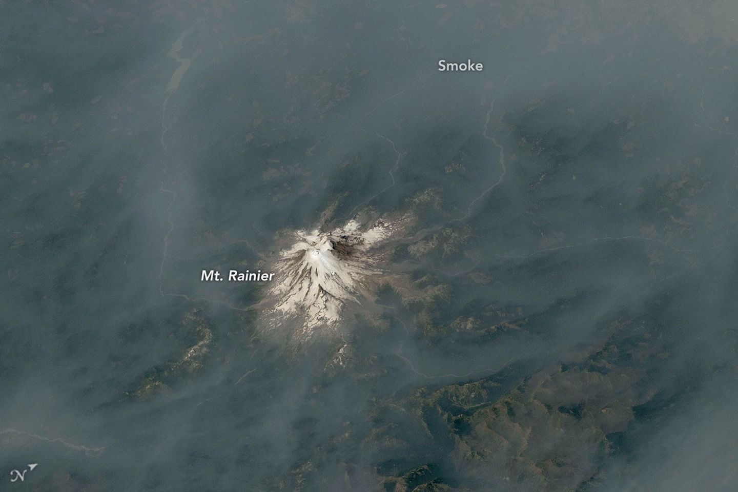
An ice-capped volcano stands at the center of the image, its surrounding terrain blanketed in brown-gray smoke.
July 31, 2026

In a contrast of fire and ice, smoke from wildland fires mingled with several of the Cascade Range’s prominent, glaciated volcanoes in summer 2026. Astronauts on the International Space Station photographed the scene while orbiting over the U.S. West in late July and early August.

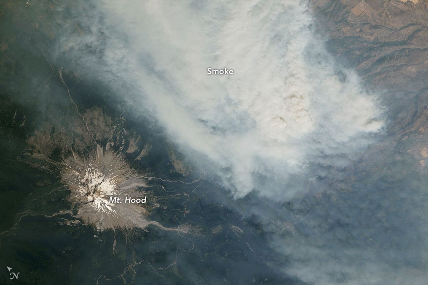
Mount Hood, Oregon’s tallest peak at 11,249 feet (3,429 meters), is pictured above, near a thick plume of smoke pouring from the Grasshopper fire. Thunderstorms passed over the forest in the preceding weeks, and a lightning strike on July 23 ignited the blaze pictured in this July 31 photo. The fire, burning east of the mountain, spread quickly north and east across Mount Hood National Forest amid hot, dry conditions, according to InciWeb.

As of August 12, it had burned nearly 84,000 acres (34,000 hectares) and spread beyond national forest boundaries. Several communities in Wasco County were under “go now” evacuation orders, and the nearby town of Dufur was advised to prepare for immediate evacuation.

An ice-capped volcano stands at the center of the image, its surrounding terrain blanketed in brown-gray smoke.
August 4, 2026

Roughly 100 miles to the north in Washington, Mount Rainier—the state’s tallest peak at 14,411 feet (4,392 meters)—was wreathed in smoke. No major fires burned nearby when this photo was taken on August 4. Instead, smoke drifted in from fires in central and eastern Washington, carried by winds blowing from the east due to a high-pressure system offshore. That day, the National Park Service reported that air quality in the park reached unhealthy levels due to elevated concentrations of fine particulate matter (PM2.5).

Several days later, the Grand Park 2 fire was observed burning within park boundaries, about 3 miles north of the Sunrise Visitor Center. As of August 12, the fire had burned 223 acres (90 hectares) and was uncontained; the cause was yet undetermined.  

Above-normal fire potential was expected to persist across the Northwest through August, according to an outlook from the National Interagency Fire Center. Warm, dry weather—conditions influenced by El Niño—combined with cured fuels to set the stage for large, long-burning fires following lightning- or human-caused ignitions.

Astronaut photographs ISS075-E-1705 and ISS075-E-2221 were acquired on July 31, 2026, and August 4, 2026, respectively, with a Nikon Z9 digital camera using a focal length of 400 millimeters. They are provided by the ISS Crew Earth Observations Facility and the Earth Science and Remote Sensing Unit at NASA Johnson Space Center. The images were taken by a member of the Expedition 75 crew. The images have been cropped and enhanced to improve contrast, and lens artifacts have been removed. The International Space Station Program supports the laboratory as part of the ISS National Lab to help astronauts take pictures of Earth that will be of the greatest value to scientists and the public, and to make those images freely available on the Internet. Additional images taken by astronauts and cosmonauts can be viewed at the NASA/JSC Gateway to Astronaut Photography of Earth. Story by Kathryn Hansen.

Downloads

An ice-capped volcano stands at the center of the image, its surrounding terrain blanketed in brown-gray smoke.

Mt. Rainier: August 4, 2026

JPEG (10.14 MB)

An ice-capped volcano stands in the bottom-left corner, with a wide plume of brown-gray smoke filling most of the rest of the frame.

Mt. Hood: July 31, 2026

JPEG (7.44 MB)

References & Resources

You may also be interested in:

Stay up-to-date with the latest content from NASA as we explore the universe and discover more about our home planet.

Smoke Streams Across Eastern Washington

3 min read

Wildland fires in early August 2026 pushed air quality to unhealthy levels, destroyed hundreds of structures, and triggered mandatory evacuations…

Article

Cottonwood Fire Chars Utah

5 min read

The blaze burned more than 150 square miles and swept through parts of a ski resort.

Article

Ontario Wildfire Smoke Moves East

3 min read

Canadian wildfires sent plumes of smoke streaming over Ontario, Quebec, and parts of the U.S. Midwest and Northeast.

Article
❌
❌