Normal view

There are new articles available, click to refresh the page.
Before yesterdaySpace

NASA’s Life-Saving Technology Where Cell Signals Can’t Go

10 September 2026 at 16:12
3 Min Read

NASA’s Life-Saving Technology Where Cell Signals Can’t Go

A group of people on a boat, several of them are wearing shirts with text reading "U.S. Coast Guard"
Rescued after more than four hours in the water, Easton Barrett (center, red shorts) and his friend were picked up by the U.S. Coast Guard thanks to a personal locator beacon (PLB). The devise sends a distress signal to satellites that are relayed back to Earth, launching a rescue operation.
Credits: Easton Barrett

Memorial Day weekend 2024 started with a blue sky and a mild three- to four-foot chop in the water off the Gulf Coast of Mississippi — a perfect day for a fishing competition. A team of five was about 40 miles offshore checking their sonar, and 30 seconds later the boat was gone. They were in the water struggling to pull on life jackets and grab the coolers as they bobbed up. When a boat sinks, survivors can be virtually invisible amid the vast expanse of water.

When their fishing trip went wrong, Easton Barrett had the only mobile phone and no cell service. He recorded a brief farewell, planning to put his phone in a cooler in hopes someone would find it.

Another team member activated a personal locator beacon (PLB) that had been stowed at the last minute, which sent a distress signal to the Search and Rescue Satellite-Aided Tracking (SARSAT) technology carried by multiple satellites in Earth orbit. In the SARSAT system, developed partly by NASA, an emergency signal containing the transmitter’s location is directed to the nearest available ground station.

A bearded man stands holding three bright green devices in front of a bag, each has the logo for ACR on it.
406 megahertz is the wavelength dedicated for PLB distress signals. On the annual 406 Day, Easton Barrett posts videos and messages on his social media accounts to help raise awareness about essential survival gear.
Credit: ACR

A mission control center then alerts rescue coordination centers to mobilize search and rescue crews. For Barrett and his crew, that was a Florida Coast Guard boat.

“Ever since, I have tried to teach others about safety on the water and in the outdoors by using a PLB,” said Barrett. “If that will save one life, it’s worth the effort.”

A beacon like the one that saved his crew, a registered ResQLink PLB developed by ACR Electronics Inc. of Fort Lauderdale, Florida, also notifies the device owner’s emergency contact, indicating a distress call was activated. All emergency beacons must meet the same requirements to ensure they work when needed. Every rugged, buoyant, handheld devices have a five- to 10-year battery life.

SARSAT began operations in 1982, becoming an international collaboration in 1985. The flight and ground technologies used globally were originally developed at NASA’s Goddard Space Flight Center in Greenbelt, Maryland. Now there are 62 satellites in the program and 45 nations contributing services, from operating ground stations to providing rescue crews. More than 63,000 lives have been saved.

A close up picture of a green ACR PLB atop a bag in a forest setting
Turning on a ResQLink View PLB from ACR Electronics will automatically “ping” orbiting satellites that send location and GPS information to the nearest search and rescue station. Whether on land or water, the appropriate resources will be dispatched to help anyone in distress anywhere in the world.
Credit: ACR

SARSAT by the Numbers

The Search and Rescue Satellite-Aided Tracking system developed over several decades by NASA and other government agencies saves lives on land or at sea.

  • 1982 — the start of U.S. operations
  • 1985 — the start of international operations
  • 62 operational satellites
  • 45 nations contributing services
  • 63,000+ lives saved

One rescue in 2024 demonstrates how it all comes together.

  • 40 miles off the Mississippi Gulf Coast
  • 5-person team participating in a fishing competition 
  • 30 seconds for a boat to sink
  • 200 pounds of bait dumped to make a cooler buoyant
  • 3 close encounters with wildlife, likely sharks and eels
  • 4 hours in the water
  • 1 personal locator beacon
  • 1 Coast Guard rescue boat
  • 5 lives saved

“If it has anything to do with NASA, it's got to be awesome.”

EASTOn Barrett

EASTOn Barrett

ACR Customer

About the Author

Margo Pierce

Science Writer

NASA Technique for Manipulating Satellite Photos Now Reveals Ancient Images  

8 September 2026 at 11:15

3 min read

Preparations for Next Moonwalk Simulations Underway (and Underwater)

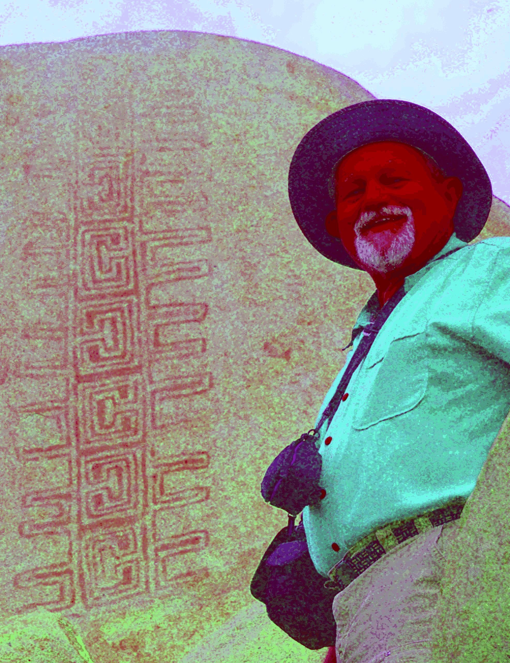
A man stands in front of a rock with art on it, the colors are intense and exaggerated revealing an intricate design in the rock's surface.
Jon Harman poses in front of an example of the Rancho Bernardo style of Native American artwork that’s barely visible until Dstretch is applied. 
Credit: Jon Harman 

High in the central tower in the ancient Cambodian temple of Angkor Wat, paintings depict horseback riders and a traditional musical ensemble. Thousands of visitors pass these images daily without noticing, because they’re faded to the point of invisibility. 

They were discovered between 2010 and 2012, along with about 200 other paintings throughout the complex, by an archaeologist using a method conceived at NASA’s Jet Propulsion Laboratory in Southern California. 

The technique, known as decorrelation stretch, heightens contrasts in digital imagery, making features easier to spot. It is especially popular for studying ancient rock art, partly due to the chance intersection of one man’s hobby with his professional background. 

Around 2005, rock art enthusiast Jon Harman saw NASA images depicting the Martian surface with and without the application of decorrelation stretch. Seeing how much detail the technique revealed, Harman, now retired in Pacifica, California, understood the implication for studying ancient, faded images. 

He also worked in medical imaging. “I Googled it and found a NASA paper that explained how to do the algorithm,” he said. “I knew from my medical imaging experience that I could do it, so I did.” 

The paper was written in 1996 by Ronald Alley, a JPL employee developing applications for the Advanced Spaceborne Thermal Emission and Reflection Radiometer (ASTER), a Japanese imaging instrument on NASA’s Terra satellite. One of Alley’s former supervisors at JPL had coinvented decorrelation stretch, and Alley had recognized its potential for gleaning information from ASTER imagery.  

Harman made his plug-in for use with ImageJ, an open-source program developed by the National Institutes of Health.  

before
after
A wall with a series of faded humanoid figures painted on it.
A new yellow figure emerges from behind the other after the dstretch algorithm is applied
A wall with a series of faded humanoid figures painted on it.
A new yellow figure emerges from behind the other after the dstretch algorithm is applied
before
after

Before and After

Dstretch applied to Cave of San Borjitas in Baja California, Mexico

As Jon Harman was developing the Dstretch plug-in, he applied it to this image from the Cave of San Borjitas in Baja California, Mexico. When the yellow figure appeared in the middle of the picture, he knew he had something useful. Credit: Jon Harman 

He said he fulfills about 200 requests for Dstretch per year. Around 2010, he also created smartphone apps that use a shortcut to mimic decorrelation stretch. The apps have been downloaded thousands of times, and papers have been published describing Dstretch’s usefulness in archaeology. 

It has been used to spot and clarify imagery at ancient sites under a cliff in Norway, in an Egyptian tomb, at a park in Canada, and in many other locations. It has also helped archaeologists find buried remains of ancient Greek buildings and examine tattoos on mummified human remains, among its non-rock-art applications.  

Harman said he was not surprised Dstretch found wide use in the rock art community. “But I’ve been surprised by a lot of the different applications people have found. So that’s been cool.”  

Share

Details

Last Updated
Sep 08, 2026

NASA Data Helps Commercial Space Plan Living Off Our Moon 

12 August 2026 at 16:40

3 min read

Preparations for Next Moonwalk Simulations Underway (and Underwater)

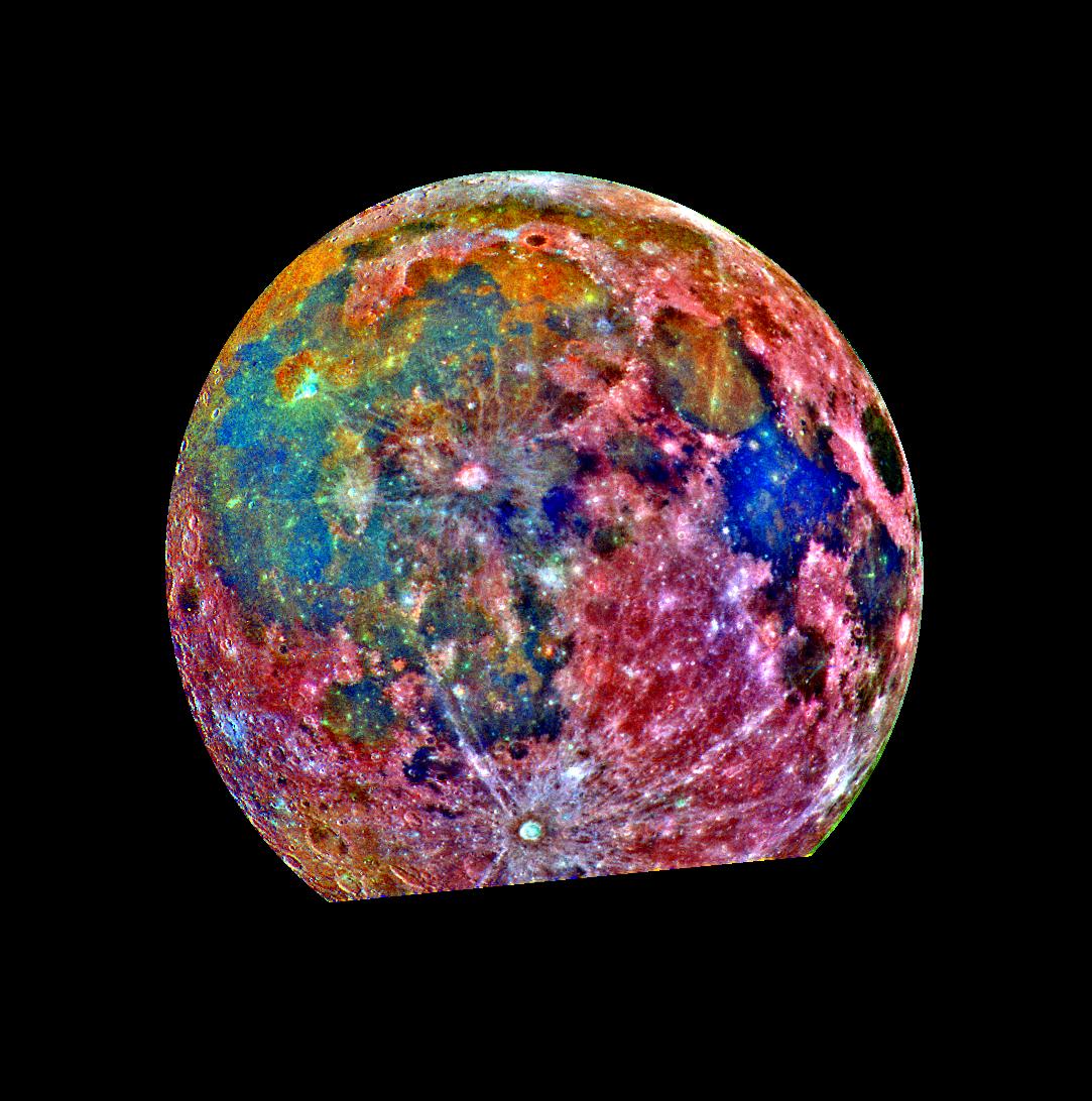
A multicolored picture of Earth's Moon.
NASA has been taking pictures of the Moon for decades, collecting a wealth of data. This false-color picture is a composite of 15 images of the Moon taken through three color filters on NASA’s Galileo solid-state imaging system.
Credit: NASA

The barren lunar landscape has some important resources, such as water and minerals like iron and titanium, but extracting and processing them will require special equipment. Where those resources can be found will dictate where to land and how to mine them. To help with that, Lunar Station Corp. is using a wealth of NASA data in multiple computer models.

“With 60 years of lunar data available to us, we help our clients understand the environmental factors for any given location on the Moon,” said Blair DeWitt, CEO of Lunar Station. Combining disparate data from different sensors used by NASA and other space agencies is a critical first step. One NASA resource the Cambridge, Massachusetts-based company used to build terrain maps is the Ames Stereo Pipeline. The open-source code automatically processes images captured from satellites, robotic rovers, historical images, and more to create a 3D model revealing features such as rock placement and elevation.

But the availability of in-situ lunar water resources at any location is largely unknown, according to Gerry Sanders, in-situ resource utilization system capability lead at NASA’s Johnson Space Center in Houston. To begin to fill that gap, the Lunar Crater Observation and Sensing Satellite was designed to crash its uppers stage into the Moon’s South Pole in 2009. The examination of the resulting plume revealed the presence of water ice.

Lunar Station is building on that work and more to help commercial space companies with mission planning, which includes scientific research for mining operations. The MoonHacker program uses proprietary geospatial analytics platform and advanced algorithms to fuse all the lunar data in NASA’s Planetary Data System to help identify indicators for shallow pits of lunar water.

“We can find sites for landing pads, for cultivating the best paths for roving, and inform our clients about communications. If you can’t see Earth at a given location like in the polar regions or the far side of the Moon, you have to come up with a relay strategy,” said DeWitt. “We can do this in part thanks to NASA data.”

In MoonHacker’s Radiation Simulator, an electronic version of a company’s rover or satellite, called a digital twin, can be subjected to the radiation en route or at the mission site to determine the protection required.

These innovations exemplify the purpose of NASA’s Technology Transfer program within the Research and Technology Mission Directorate, which uses space-based solutions to improve life on Earth. For 50 years, NASA has documented the everyday benefits of space technology through the agency’s Spinoff publication. 

Share

Details

Last Updated
Aug 12, 2026
❌
❌