Reading view

There are new articles available, click to refresh the page.

A Sunflower’s View of Totality

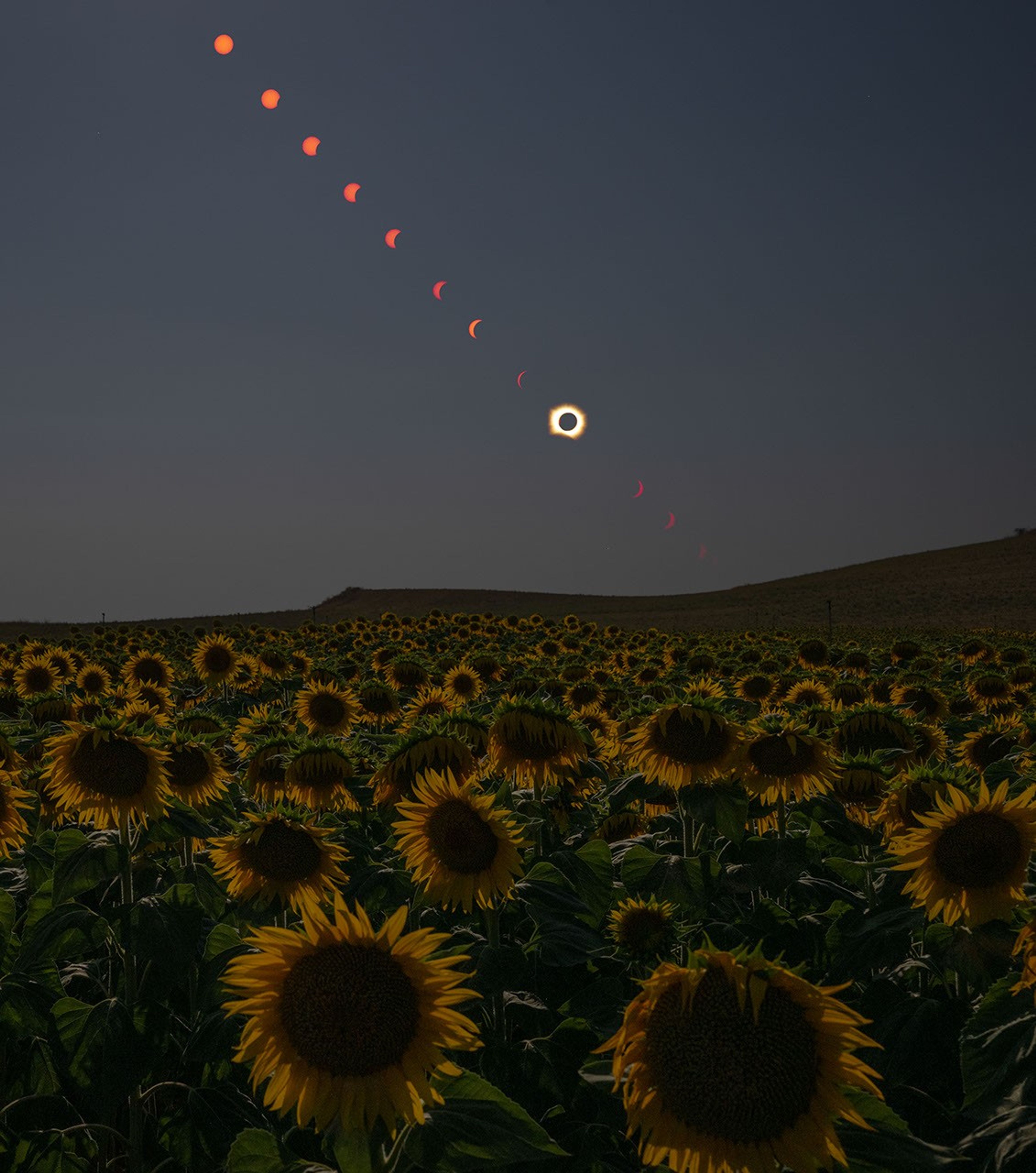
A composite photo shows the Sun at several times and locations during the progression of a total solar eclipse. The Sun’s path descends diagonally from the top left across a dimmed sky, with a field of sunflowers in the foreground.
A composite image shows the progression of a total solar eclipse over San Millán de los Caballeros, Spain, on August 12, 2026.

Skywatchers across a swath of northern Spain witnessed a total solar eclipse when the Moon lined up directly between the Sun and Earth on August 12, 2026. Those within the path of totality had the rare chance to glimpse the Sun’s active outer atmosphere, or corona, during the short time the Moon blocked the Sun.

This composite photo was taken before, during, and after the total eclipse from a field of appropriately themed flowers in San Millán de los Caballeros, a town about 40 kilometers (25 miles) south of León in northwestern Spain. Along with parts of Greenland and Iceland, Northern Spain was one of the few places on land that fell within this eclipse’s path of totality.

Sunset was approaching when the Moon’s shadow, or umbra, swept across Spain. In León, the partial eclipse began at 7:32 p.m. and ended at 9:22 p.m. local time, just minutes before the Sun dipped below the horizon. Totality lasted about two minutes, starting at 8:28 p.m. Farther east in Spain, the Sun set before the eclipse ended.
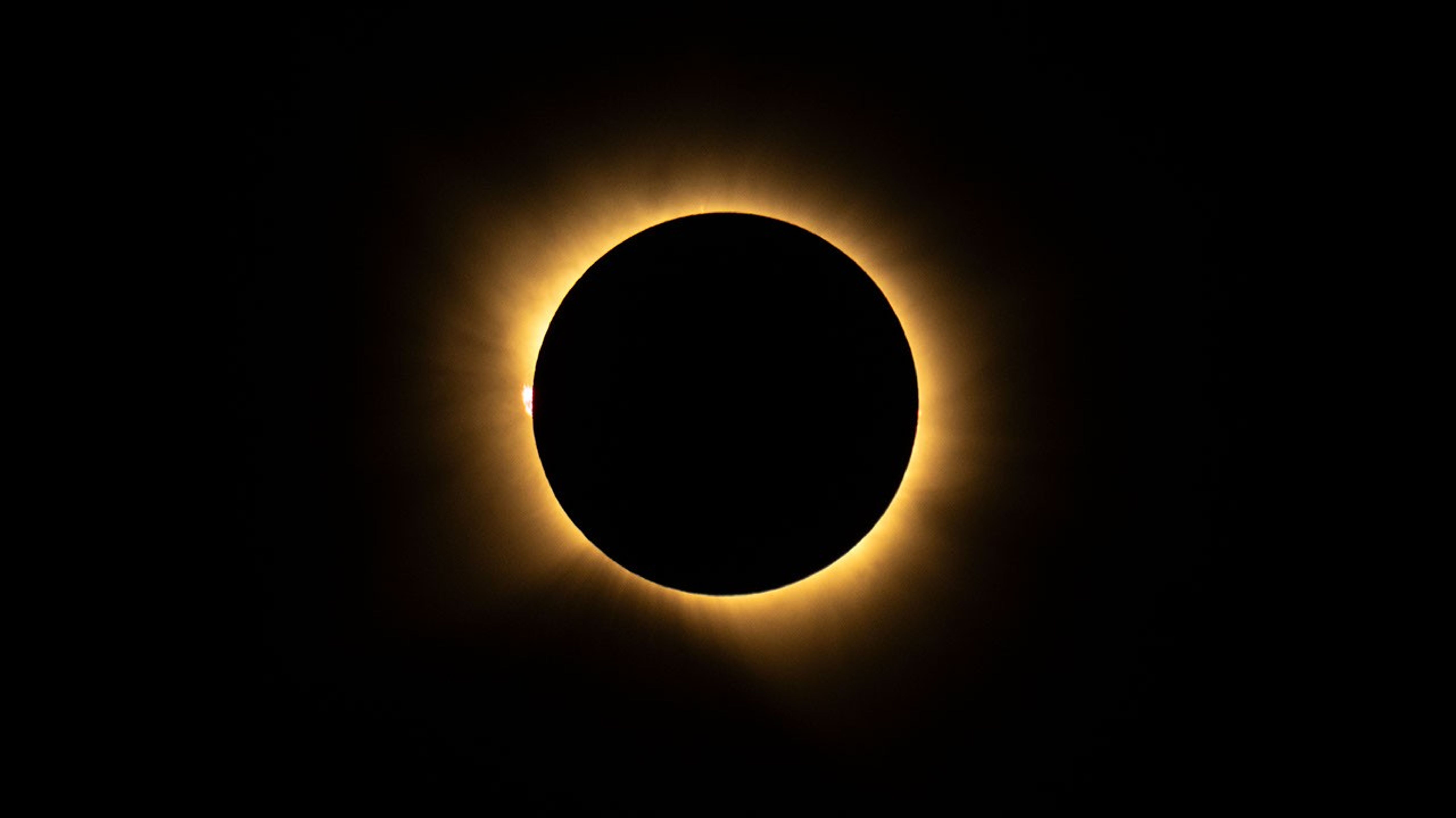
A ring of bright light shines from behind the Moon, which appears as a black circle, during a total solar eclipse.
A total solar eclipse is seen from San Millán de los Caballeros, Spain, on August 12, 2026.

In the photo above, taken during totality, a glowing loop of plasma called a solar prominence is visible extending into the corona on the left. Plasma, a super-hot gas composed mostly of ionized hydrogen and helium, flows along the tangled and twisted structure of the Sun’s magnetic fields. Solar prominences, which can measure many times higher than Earth is wide, are sometimes visible to the naked eye during eclipses.

Solar eclipses offer NASA the opportunity to get a different look at the Sun and our own atmosphere. On August 12, science teams staged in Iceland to chase the Moon’s shadow in one of NASA’s WB-57 high-altitude jets and image the corona in visible and infrared light. And the NASA-supported Nationwide Eclipse Ballooning Project launched scientific balloons before, during, and after the eclipse to measure how Earth’s atmosphere changed when the Sun was temporarily blocked.

While viewing opportunities in the path of totality were limited, the rest of Europe and parts of Africa, Canada, and the U.S. experienced a partial eclipse. Photos and video from the total and partial eclipse are available in NASA’s image library. The next total solar eclipse will occur on August 2, 2027, with the path of totality crossing southern Spain, North Africa, Saudi Arabia, and Yemen. 

NASA photos by Bill Ingalls. Story by Lindsey Doermann.

References & Resources

You may also be interested in:

Stay up-to-date with the latest content from NASA as we explore the universe and discover more about our home planet.

Stops Along the Path of Totality

3 min read

Western Iceland and northern Spain are among the few Northern Hemisphere locations experiencing a total solar eclipse on August 12,…
Article

A Moonlit Earth as Seen From Artemis II

4 min read

An astronaut’s photo, taken en route to the Moon, reveals our planet and its place in space in a novel…
Article

Earthset From the Lunar Far Side

2 min read

The crew of NASA’s Artemis II mission captured extraordinary images of our home planet during their journey around the far…

Article

Stops Along the Path of Totality

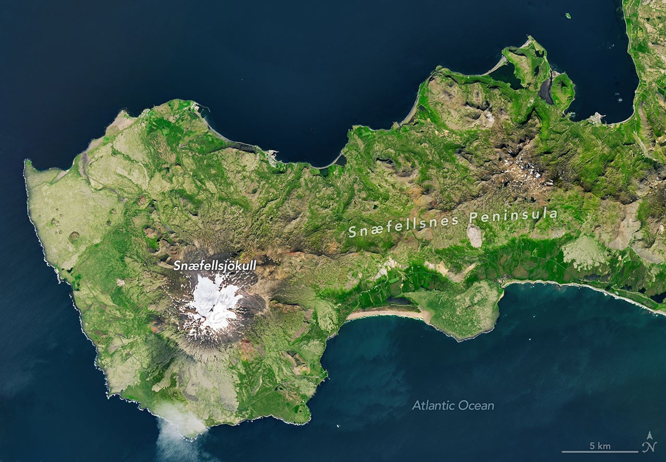
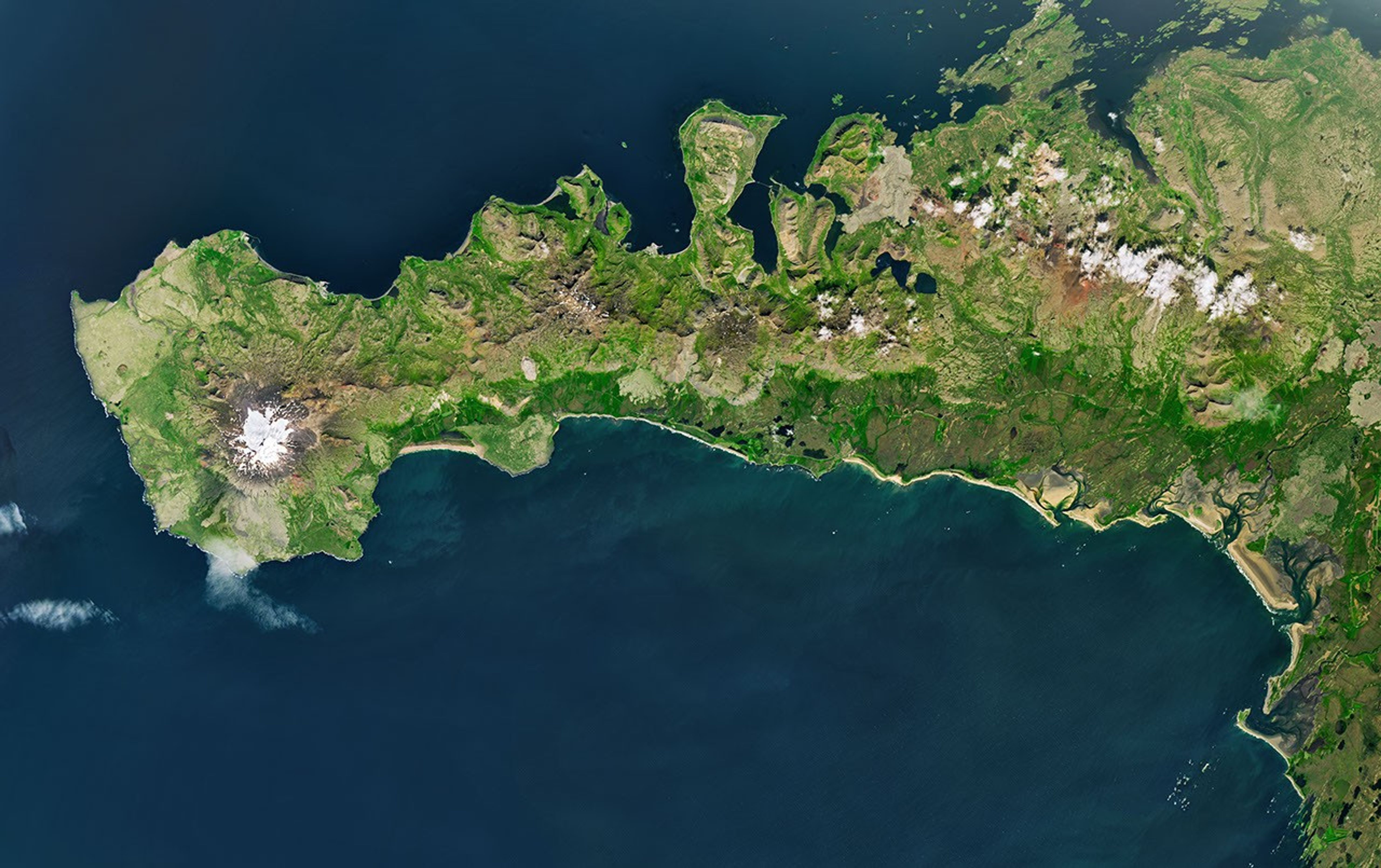
A peninsula in Iceland stretches across the image to the left. A prominent glacier-capped volcano sits near its western end.
The glacier-capped Snæfellsjökull volcano is the defining feature of Iceland’s Snæfellsnes peninsula, shown in this image acquired with the OLI (Operational Land Imager) on Landsat 9 on July 25, 2026.
NASA Earth Observatory/Michala Garrison

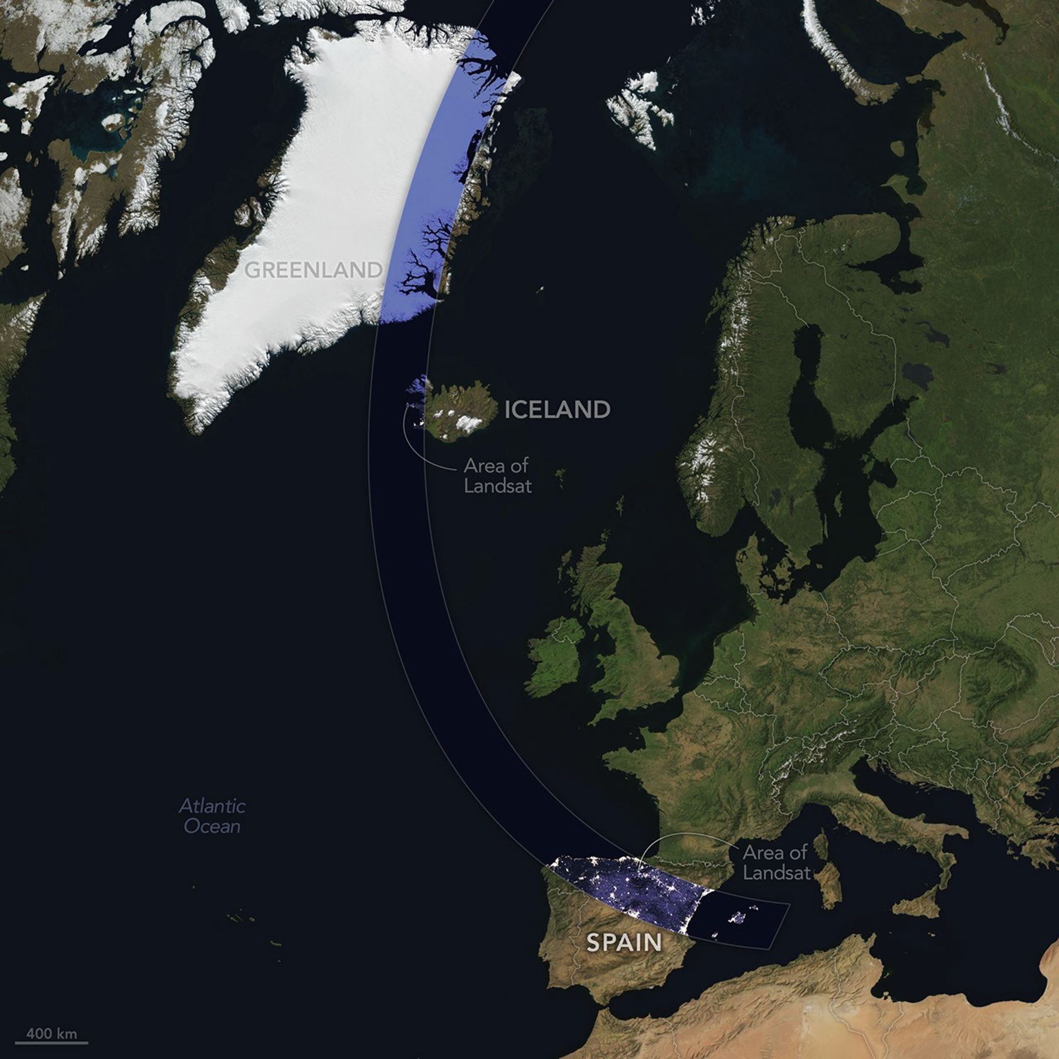
The Sun, Moon, and Earth align on August 12, 2026, to produce a total solar eclipse. When this celestial event last occurred, on April 8, 2024, the path of totality stretched across North America, giving millions the chance to glimpse the Sun’s corona. In 2026, the viewing locales are more limited; only a handful of land areas in the Northern Hemisphere, including parts of Iceland and Spain, fall within the path of totality.

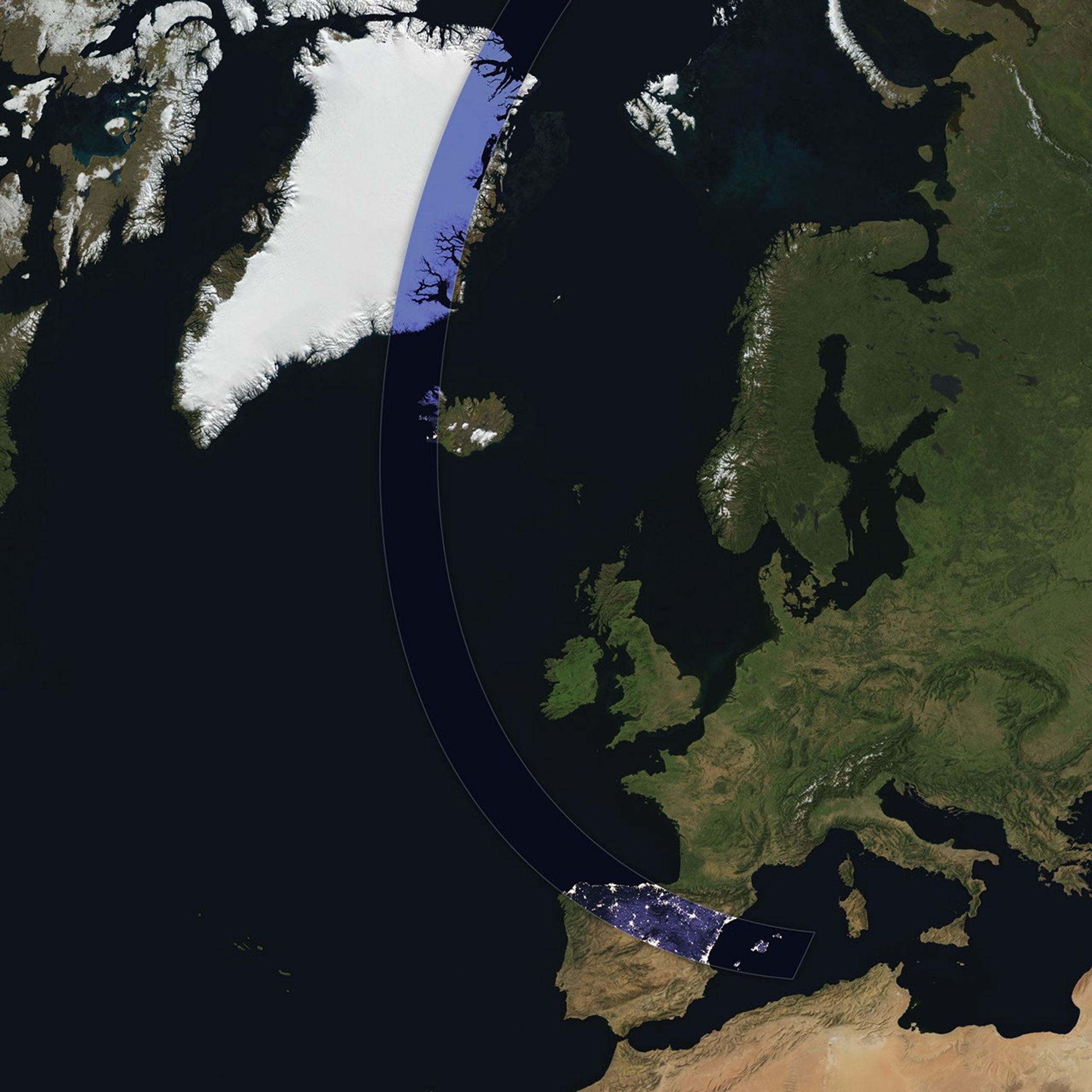
On August 12, the Moon’s shadow will first cross over the Arctic Circle from northern Russia and then track along the eastern side of Greenland. At about 5:45 p.m. local time in Iceland (17:45 Universal Time), the country’s western fringes—including the Snæfellsnes peninsula, shown in the Landsat image above—will begin to experience totality. The greatest eclipse will occur near this sparsely populated peninsula when the Moon appears the largest and covers more of the Sun.

A map shows the path of totality of the solar eclipse on August 12, 2026, arcing across Greenland, Iceland, the North Atlantic, and Spain.
The path of totality of the solar eclipse on August 12, 2026, spans Greenland, Iceland, and Spain. The base imagery for the map comes from Blue Marble: Next Generation, with data from Black Marble shown in the path of totality. Blue Marble is built from scenes captured by MODIS (Moderate Resolution Imaging Spectroradiometer), while Black Marble is based on observations by the VIIRS (Visible Infrared Imaging Radiometer Suite) day-night band.
NASA Earth Observatory/Michala Garrison

The Snæfellsjökull volcano on the western end of the peninsula is covered in ice and last erupted about 1,800 years ago. It is the highlight of a national park of the same name, where people are expected to visit to view the eclipse. The stratovolcano even has a literary claim to fame: in Jules Verne’s A Journey to the Center of the Earth, characters venture underground through its crater, later emerging in an eruption of Stromboli, in Italy. In 2025, a broader area of the peninsula was designated a UNESCO biosphere reserve, containing over 70 percent of Iceland’s flora and an agglomeration of volcanic landscapes, wetlands, and grasslands.

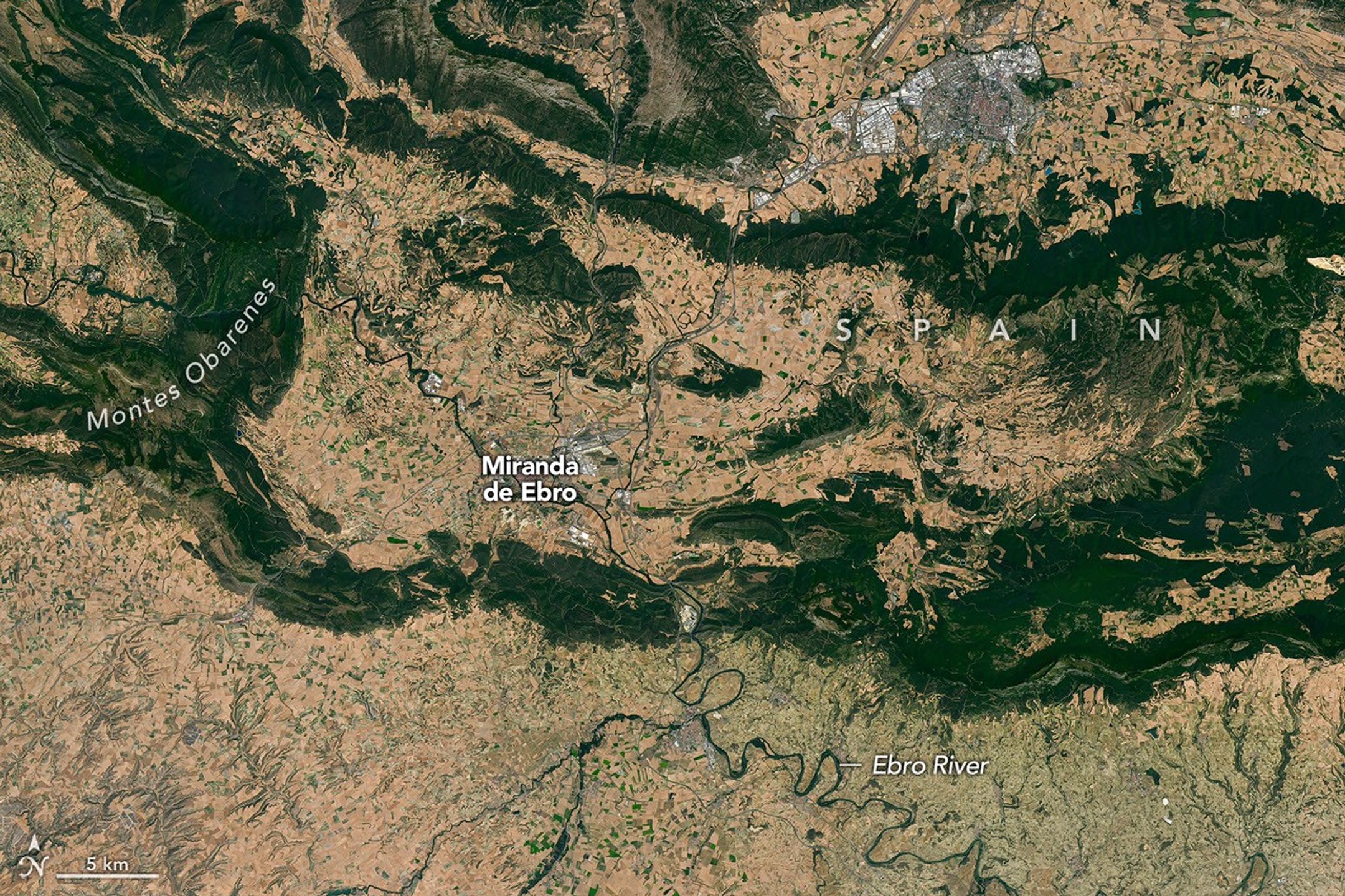
From Iceland, the eclipse shadow, or umbra, progresses across the North Atlantic and reaches northern Spain shortly before sunset. It runs east-southeast across the country, much like the Ebro River (Río Ebro), seen in the Landsat image below.

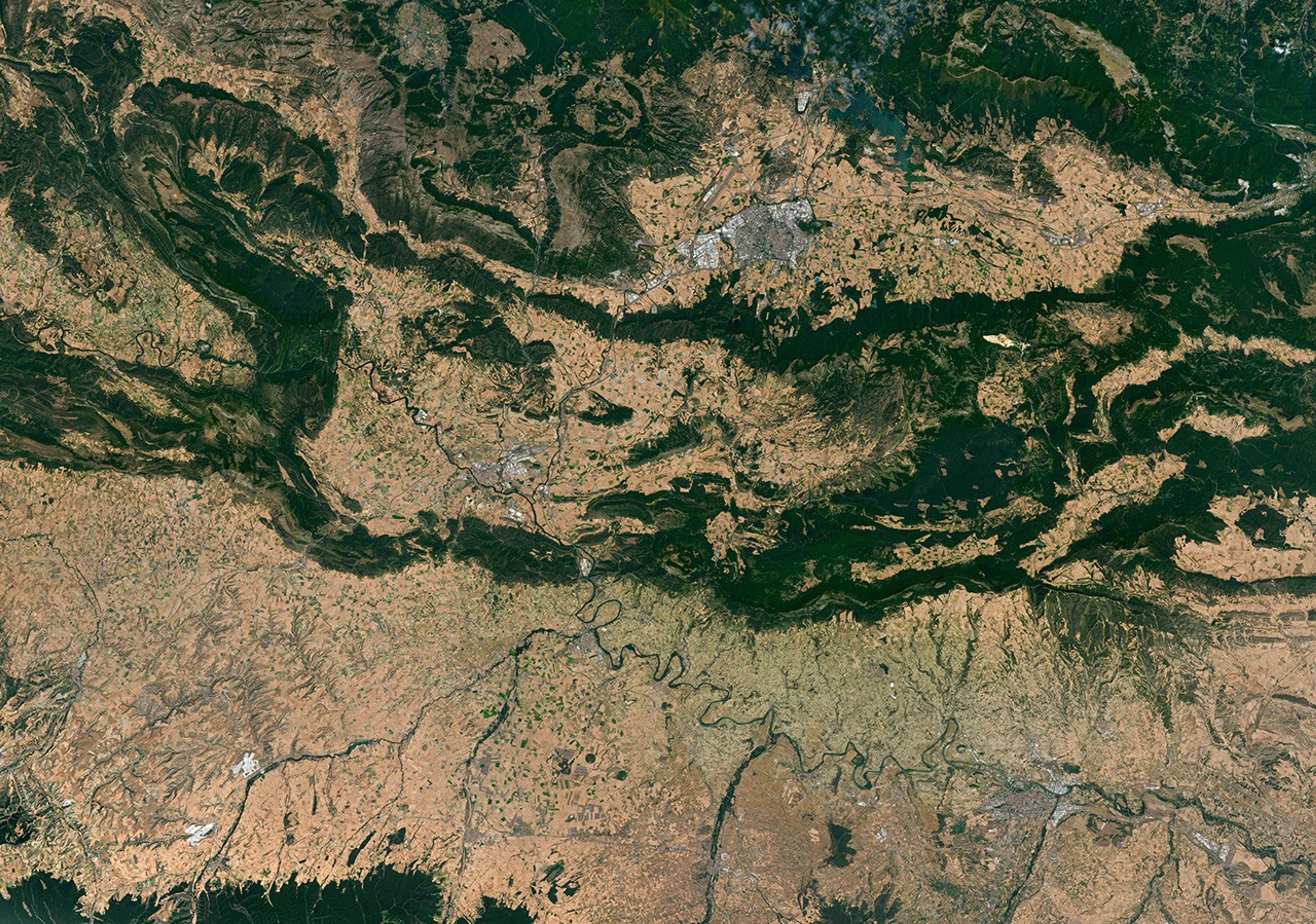
Meandering rivers cut through dark green mountain ridges, across agricultural land, and near several developed areas in northern Spain.

The Ebro River, meandering across northern Spain in this image acquired with the OLI (Operational Land Imager) on Landsat 8 on July 21, 2026, is in the path of totality of the August 2026 solar eclipse.
NASA Earth Observatory/Michala Garrison

The upper Ebro emerges from rugged terrain in Parque Natural de Montes Obarenes-San Zadornil, where it carves canyons and gorges through the eastern foothills of the Cantabrian Mountains. It then meanders through La Rioja, a region known for its vineyards. About 400 kilometers (250 miles) away, the river reaches a delta on the Mediterranean coast between Barcelona and Valencia.

Based on satellite measurements of cloud cover in August over several decades, viewers in Spain have a higher likelihood than those in Iceland of getting a clear look at the eclipse. And despite limited viewing opportunities in the path of totality, the rest of Europe, parts of Africa, Canada, and the northern and northeastern U.S. will experience a partial eclipse.

NASA Earth Observatory images and map by Michala Garrison, using Landsat data from the U.S. Geological Survey, base imagery from Blue Marble: Next Generation and Black Marble, and eclipse path data from Xavier Jubier. Story by Lindsey Doermann.

Downloads

A peninsula in Iceland stretches across the image to the left. A prominent glacier-capped volcano sits near its western end.

July 25, 2026

JPEG (14.69 MB)

A map shows the path of totality of the solar eclipse on August 12, 2026, arcing across Greenland, Iceland, the North Atlantic, and Spain.

August 12, 2026

JPEG (1.92 MB)

Meandering rivers cut through dark green mountain ridges, across agricultural land, and near several developed areas in northern Spain.


July 21, 2026

JPEG (34.46 MB)

References & Resources

You may also be interested in:

Stay up-to-date with the latest content from NASA as we explore the universe and discover more about our home planet.

Colonial National Historical Park

2 min read

The colonial communities of “America’s historic triangle” played defining roles in the road to American independence.

Article

Minute Man National Historical Park

3 min read

Sites relevant to the start of the American Revolutionary War are interspersed throughout the modern-day Boston metropolitan region.

Article

Earthset From the Lunar Far Side

2 min read

The crew of NASA’s Artemis II mission captured extraordinary images of our home planet during their journey around the far…

Article
❌