Reading view

There are new articles available, click to refresh the page.

What Lake Bonneville Left Behind

Tan and white plains surround a dark mountainous ridge in a three-dimensional image of the Silver Island Mountains.
The rugged terrain of the Silver Island Mountains and Crater Island rises above the pale playa and bright salt flats of former Lake Bonneville. The image was acquired with the OLI (Operational Land Imager) on Landsat 8 on June 4, 2026, and overlaid on a digital elevation model.
NASA Earth Observatory/Michala Garrison

At its peak, ancient Lake Bonneville would have been a sight to behold. Nearly as large as Lake Michigan, the Ice Age lake spread across much of western Utah and parts of Nevada and Idaho. When it eventually receded, it left behind flat, bright playas and salt flats rich with minerals—a landscape that would later serve as the setting for feats of engineering and technological ingenuity, as well as epic tales of exploration and desperation.

Lake Bonneville began forming about 55,000 years ago during a cool, wet period, when volcanic eruptions in what’s now southeastern Idaho diverted the Bear River, causing water to gather in Gem Valley and other basins to the south. For tens of thousands of years, a natural dam at Red Rock Pass helped confine the lake.

Then, about 18,000 years ago, water breached that dam, unleashing a torrent that entered the Columbia River system. Over a six-week period, amid one of North America’s largest floods, lake levels plummeted by more than 350 feet (105 meters). As the climate warmed and dried in subsequent millennia, the lake shrank dramatically, leaving remnants that include today’s Great Salt Lake, Utah Lake, and Sevier Lake.

Lake Bonneville may be gone, but its imprint on the region’s landscape remains—even in satellite imagery. In this image (below) captured by the OLI (Operational Land Imager) on the NASA-USGS Landsat 8 satellite, bathtub-like rings and wave-cut terraces trace the position of former shorelines. The dried lakebed—where fine-grained clay, marl, and sandy sediment settled out of the water—appears pale in comparison to the darker, rockier, more vegetated surroundings.
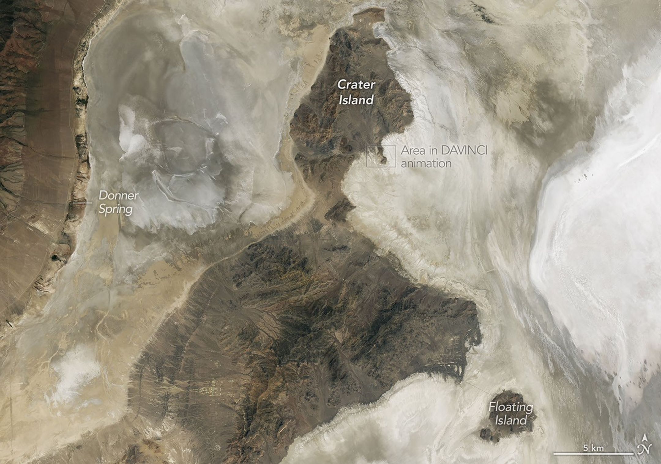
A nadir view shows Crater Island—a dark, linear mountain ridge in the center of the image—flanked by flat tan and white landscapes.
NASA scientists analyzed the terrain in this part of Utah when testing technologies that will be used on NASA’s DAVINCI mission to Venus. This image was acquired with the OLI (Operational Land Imager) on Landsat 8 on June 4, 2026.
NASA Earth Observatory/Michala Garrison

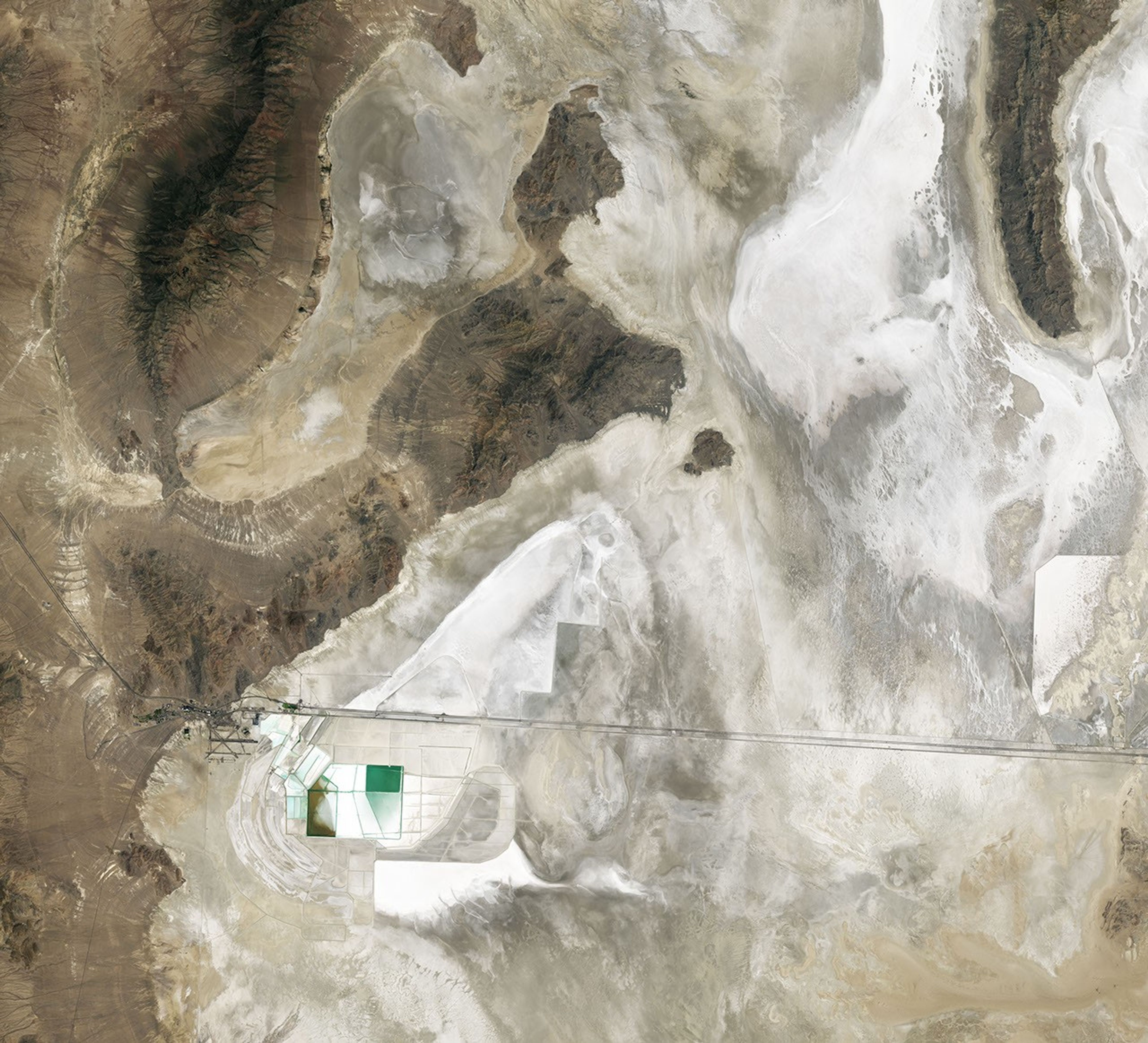
In deep parts of the basin, where runoff and groundwater still pool, bright deposits of evaporite minerals coat the land surfaces, forming salt flats. These remarkably flat surfaces are the product of water gradually evaporating and concentrating minerals to produce brines and hard mineral crusts, typically including halite and gypsum, along with potassium- and magnesium-bearing salts. Brines and deposits like these—particularly of potash, which is used as a fertilizer—have long made the playa a target for mining, as seen in the rectangular evaporation ponds above and below.

In contrast, the darker, more rugged terrain—including the Silver Island Mountains, the Newfoundland Mountains, and the Pilot Range—that rises above the playas is built from layers of erosion-resistant sedimentary and metasedimentary bedrock that is hundreds of millions of years old. These mountains also contain younger igneous and metamorphic rocks that formed when magma intruded into the ancient sedimentary sequence.

Crater Island, for instance, is composed of sedimentary rocks, including silica-rich sandstones and quartzites that formed as sands accumulated in a shallow ocean, as well as intrusions of quartz monzonite, granites, and other igneous rocks. Periods of crustal stretching later produced the fault-block mountains that define the landscape.
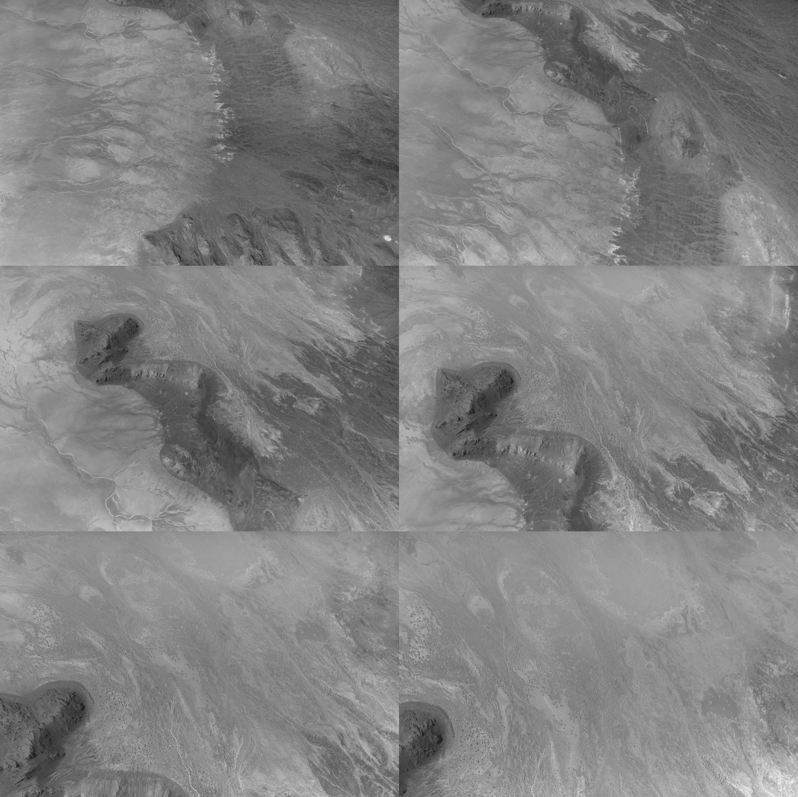
Grayscale aerial image of rugged desert terrain showing branching channels, ridges, and broad textured plains with contrasting light and dark tones.
This animation shows the descent over Crater Island, Utah, of the camera system that will one day fly aboard NASA’s DAVINCI mission to Venus. It was created by stitching together 37 infrared images captured during a test on June 24, 2026.
Malin Space Science Systems/NASA/Jay Friedlander

Mapping geological distinctions like this took center stage in June 2026 when NASA scientists and engineers working with the agency’s DAVINCI mission came to Crater Island—a place they call “Venus on Earth”—to field-test the design of a set of cameras and a package of instruments that will eventually descend through the thick atmosphere of Venus and photograph mountains at scales finer than these Landsat images. During a 60-minute descent, the pioneering probe will capture near-infrared images, measure the atmospheric chemistry, and explore the environment of a world in unprecedented detail.

During the rehearsals at Crater Island, the camera system took hundreds of images of various rock formations, including iron-rich and silica-rich rock units, while suspended from a helicopter as it descended toward the surface. Using only the images acquired by DAVINCI’s camera systems, the team made three-dimensional maps of the area consistent with existing geologic maps, giving the scientists confidence that they will be able to map the geology of an analogous mountainous region on Venus that DAVINCI will study, an area called Alpha Regio.

Other epic adventures have played out on and around Lake Bonneville’s playas, as well. The flat, smooth surfaces have often been the setting for new land speed records. In 1960, Mickey Thompson became the first American to break the 400-miles-per-hour (640 kilometers-per-hour) barrier, hitting 406.60 miles per hour (654.36 kilometers per hour) in a streamlined race car on the Bonneville Salt Flats. The feat temporarily earned him the nickname “fastest man on Earth.”
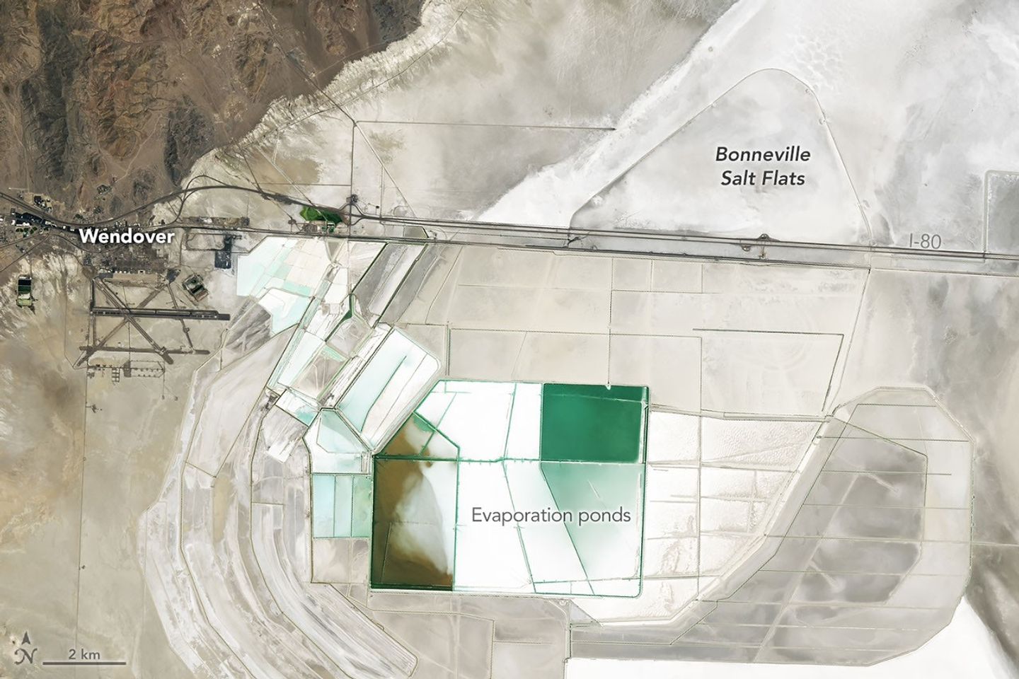
Straight roads, colorful evaporation ponds, and a long racetrack are visible on bright white salt flats in a satellite image centered east of Wendover.
People mine minerals from the Bonneville Salt Flats and use its flat surface to pursue land speed records. This image was acquired with the OLI (Operational Land Imager) on Landsat 8 on June 4, 2026.
NASA Earth Observatory/Michala Garrison

More recently, in August 2026, Andy Green, the first person to break the sound barrier on land, set a record for the fastest land speed in a hydrogen-fueled internal-combustion vehicle, reaching 406.320 miles per hour (653.909 kilometers per hour). By burning hydrogen rather than gasoline, the “rocket car” produced no carbon dioxide.

Nearly two centuries earlier, in August 1846, members of the ill-fated Donner-Reed Party also passed along the southern edge of Crater Island. As part of a shortcut toward Pilot Peak, they journeyed from Hastings Pass, past Floating Island, and toward Donner Spring. However, in an ominous sign of challenges to come, their heavy wagons broke through the thin salt crust and became mired in underlying mud, slowing them down and prompting them to abandon several wagons in the desert.

NASA Earth Observatory images by Michala Garrison, using Landsat data from the U.S. Geological Survey. Story by Adam Voiland.
Downloads

A nadir view shows Crater Island—a dark, linear mountain ridge in the center of the image—flanked by flat tan and white landscapes.

June 4, 2026

JPEG (14.24 MB)

Tan and white plains surround a dark mountainous ridge in a three-dimensional image of the Silver Island Mountains.

June 4, 2026: Oblique map

JPEG (2.87 MB)

References & Resources

You may also be interested in:

Stay up-to-date with the latest content from NASA as we explore the universe and discover more about our home planet.
Farming in Ancient Lake Agassiz

3 min read

The glacial lake left a layer of silt and clay in southeastern Manitoba, creating fertile farmland that was divided during…
Article

Rising Waters Swamp Lake Naivasha

6 min read

Relentless rains are threatening a lake in Kenya’s Great Rift Valley that has become a key hub in the global…
Article

America’s Emerald Isle

3 min read

Beaver Island is one in a string of verdant and scenic jewels in a northern Lake Michigan archipelago.

Article

How the Tide Turns at the Mouth of the Elbe


August 15, 2025
May 11, 2025

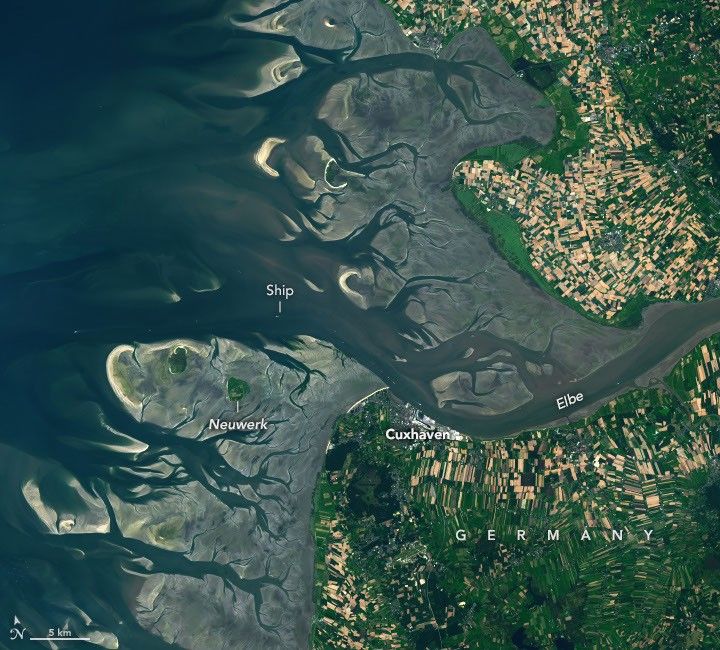
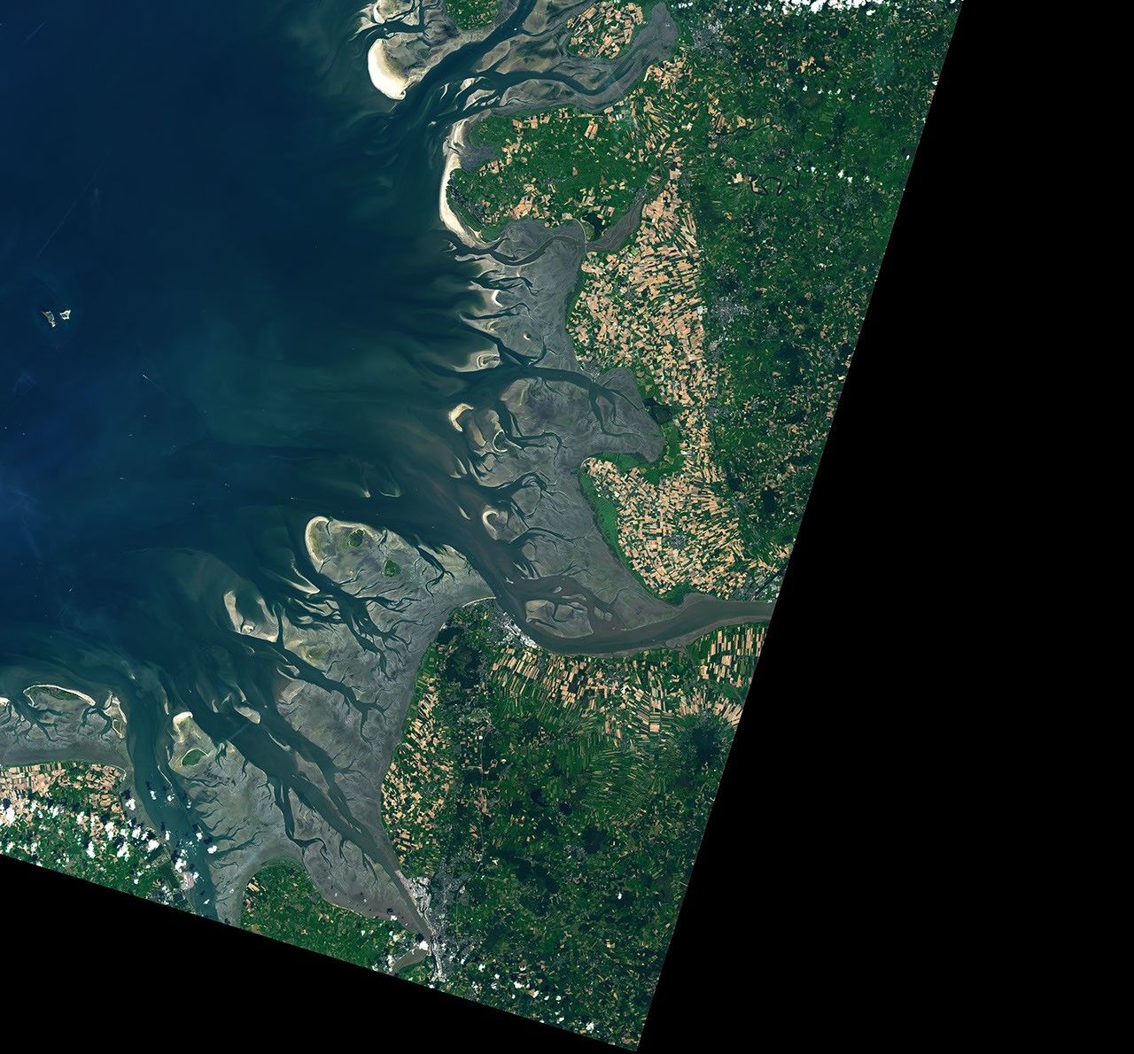
The Elbe river in Germany into the North Sea on the left side of the image. Low tide exposes wide, light-colored tidal flats interrupted by branching channels of dark water.
The ocean’s ebbs and flows reveal dynamic tidal flats and a well-traveled shipping route along the German coast.
NASA Earth Observatory/Lauren Dauphin

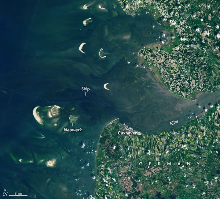
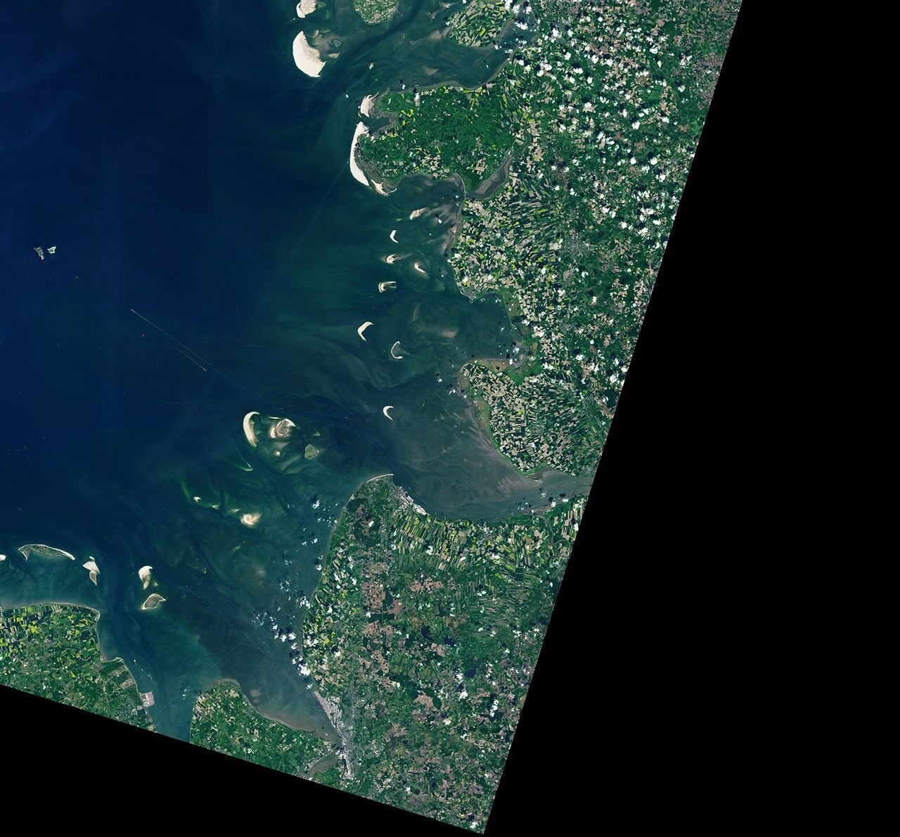
The Elbe river in Germany into the North Sea on the left side of the image. At high tide, a handful of small islands and crescent-shaped sandbars remain exposed above the water level near shore. Ships are visible as small, bright specks on the water.
The ocean’s ebbs and flows reveal dynamic tidal flats and a well-traveled shipping route along the German coast.
NASA Earth Observatory/Lauren Dauphin

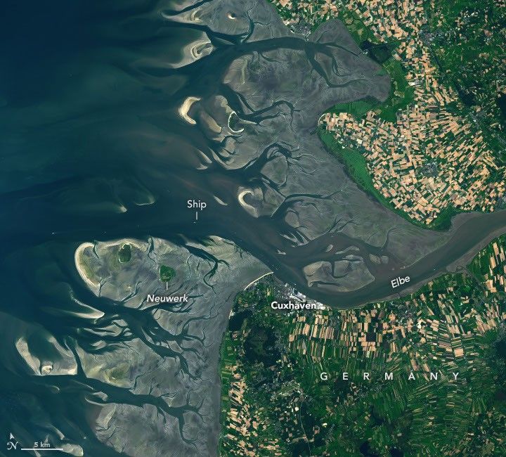
The Elbe river in Germany into the North Sea on the left side of the image. Low tide exposes wide, light-colored tidal flats interrupted by branching channels of dark water.
The ocean’s ebbs and flows reveal dynamic tidal flats and a well-traveled shipping route along the German coast.
NASA Earth Observatory/Lauren Dauphin
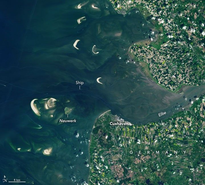
The Elbe river in Germany into the North Sea on the left side of the image. At high tide, a handful of small islands and crescent-shaped sandbars remain exposed above the water level near shore. Ships are visible as small, bright specks on the water.
The ocean’s ebbs and flows reveal dynamic tidal flats and a well-traveled shipping route along the German coast.
NASA Earth Observatory/Lauren Dauphin

August 15, 2025

May 11, 2025


One of the major rivers of Europe, the Elbe flows more than 1,000 kilometers (600 miles) across the continent before reaching the North Sea. At its mouth, the low-lying landscape is continually reshaped by the rise and fall of the tides. These dynamic tidal flats are a boon to biodiversity while sometimes posing challenges for those navigating its waters and for communities living along its shores.

The images above illustrate how the area changes with the tides. They were acquired on August 15, 2025, at low tide (left) and on May 11, 2025, at high tide (right) with the OLI (Operational Land Imager) on Landsat 9. The mean tidal range at Cuxhaven is 2.9 meters (9.5 feet), which is considered intermediate, or mesotidal. The tides are also asymmetrical, meaning the flood period is shorter than the ebb. This causes the incoming current to run faster and typically carry more sediment up the 140-kilometer-long (87-mile-long) estuary than it does out.

The low tide exposes complex channels, sandbars, and mudflats around the river mouth. This wide zone of coastal wetlands is part of the Wadden Sea, which stretches from the Netherlands to southern Denmark and represents the largest continuous system of intertidal sand and mud flats in the world. Its habitats serve as important staging, molting, and wintering grounds for migratory birds, with more than 10 million passing through every year.

A channel cuts through these natural features near the river’s mouth, allowing ships to reach Cuxhaven and Hamburg—the third-largest container port in the European Union—farther upriver. Dredging is required to remove accumulated sediment in the channel, and some ships can only pass through when the tide is high enough. The Elbe’s mouth also provides access to the Kiel Canal, which connects the North Sea and Baltic Sea and is the world’s busiest human-made waterway navigable by seagoing ships. 

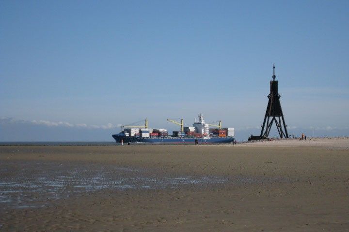
A broad tidal mudflat fills the foreground of this photo.  A sliver of deeper water is visible on the horizon, where a cargo ship loaded with shipping containers and cranes appears to be traveling to the left.
A cargo ship passes by mudflats at the mouth of the Elbe.
Thomas Gölles, April 5, 2009.

At high tide (right), only a handful of small islands and sandbars remain above the waves. One of these islands, Neuwerk, is a tranquil tourist destination that is home to a few dozen inhabitants and the oldest building on the German coast. A brick tower, completed in 1310 and later converted to a lighthouse, was built to protect shipping on the Elbe from pirates and wreckers.

These images show normal tidal variation in the area, but storms can push water levels much higher than a typical high tide. The highest water level measured at Cuxhaven—5.1 meters (16.7 feet) above Europe’s official sea level reference—occurred on January 3, 1976, when a fast-moving storm swept across the North Sea and slammed the coast with high winds. Researchers who reconstructed historical storms noted that the storm surge was worsened by its timing relative to the tide. The strongest winds arrived around low tide, preventing water that had propagated upstream at high tide from flowing back out to sea and causing further inundation inland.

Scientists study past extreme events like this to better understand how future storms might affect low-lying coastal areas and how flood protection could be improved. Flooding risks can be exacerbated by rising sea levels, which at Cuxhaven have trended upward by 2.12 millimeters per year, or 0.70 feet per century.

Two new Earth-observing satellites are making it possible to measure water levels in coastal areas in greater detail. The dual-band radar on the NISAR (NASA-ISRO Synthetic Aperture Radar) satellite is expected to track long-term phenomena such as sea level changes, as well as to map flood inundation and other ephemeral events. In addition, early data from NASA’s SWOT (Surface Water and Ocean Topography) satellite has demonstrated the potential to accurately measure water levels around complex coastlines and to improve tidal models.

NASA Earth Observatory images by Lauren Dauphin, using Landsat data from the U.S. Geological SurveyPhoto by Thomas Gölles. Story by Lindsey Doermann. 

Downloads

The Elbe river in Germany into the North Sea on the left side of the image. Low tide exposes wide, light-colored tidal flats interrupted by branching channels of dark water.

August 15, 2025

JPEG (6.33 MB)

The Elbe river in Germany into the North Sea on the left side of the image. At high tide, a handful of small islands and crescent-shaped sandbars remain exposed above the water level near shore. Ships are visible as small, bright specks on the water.

May 11, 2025

JPEG (6.02 MB)

References & Resources 

You may also be interested in:

Stay up-to-date with the latest content from NASA as we explore the universe and discover more about our home planet.

A Tide-Fueled Trove of Biodiversity in Guinea-Bissau

3 min read

The expansive mudflats, sandy beaches, and mangrove forests of the Bijagós archipelago support an array of migratory shorebirds and large…

Article

Signs of Thaw in the Bering Sea

3 min read

Drifting sea ice fragments near Alaska’s Saint Lawrence and Nunivak islands and colorful water around the Yukon Delta heralded the…

Article

Barents Sea Tied to Low Arctic Sea Ice

4 min read

Patches of open water in the region contributed to low sea ice extent across the Arctic in March 2026, which…

Article
❌