Reading view

There are new articles available, click to refresh the page.

New NASA Earth Missions Gear Up to Start Science Flights  

6 Min Read

New NASA Earth Missions Gear Up to Start Science Flights  

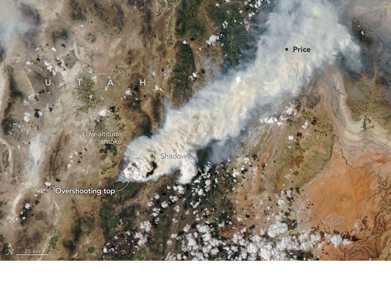
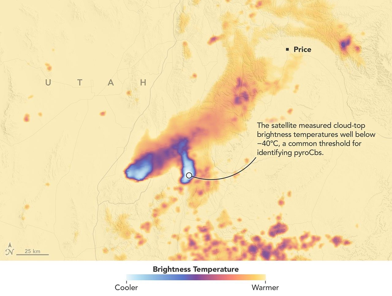
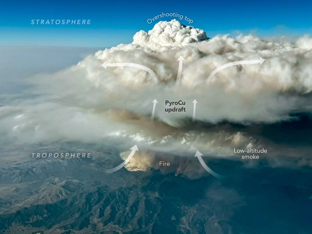
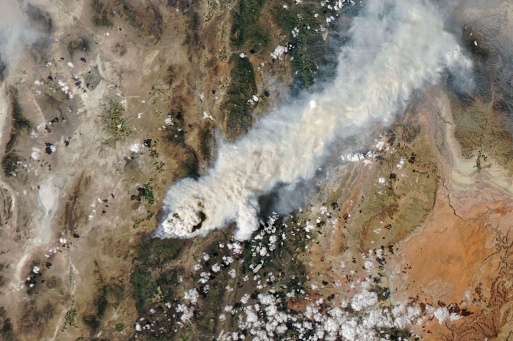
Satellite imagery captured wildfires burning hot enough to generate pyrocumulonimbus clouds north of Lake Superior in July 2026. NASA aircraft will help scientists study the powerful storms as they develop.
Credits:
CSU/CIRA & NOAA

Landslides in Alaska. Air quality in Atlanta. Fire clouds out West. From the Arctic fringes to farm country, NASA’s newest class of suborbital Earth Venture missions is gearing up to deliver science that will benefit communities in the United States and beyond. 

The six projects will mobilize hundreds of scientists and pilots from NASA, the U.S. Navy, universities, and other institutions over the next several years. While the investigations range across topics, a defining feature of suborbital missions is the use of sensors mounted on aircraft. 

Airborne remote sensing serves as a bridge between ground-based instruments and satellites. Data collected via planes, helicopters, drones, and balloons can fill in gaps in computer models used by weather forecasters, city planners, and others.  

When wildfires create their own weather 

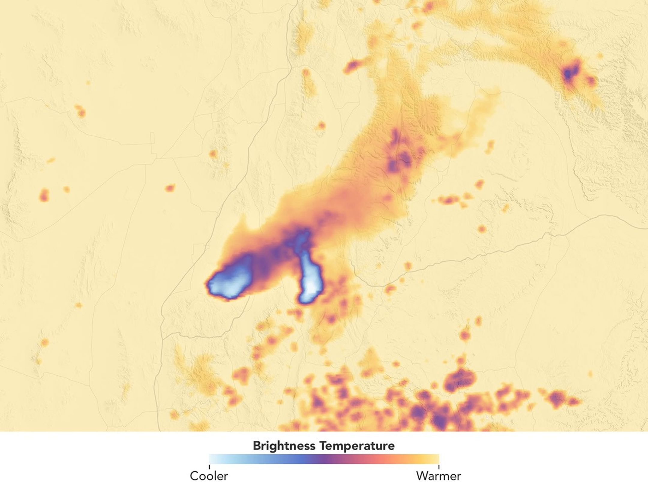
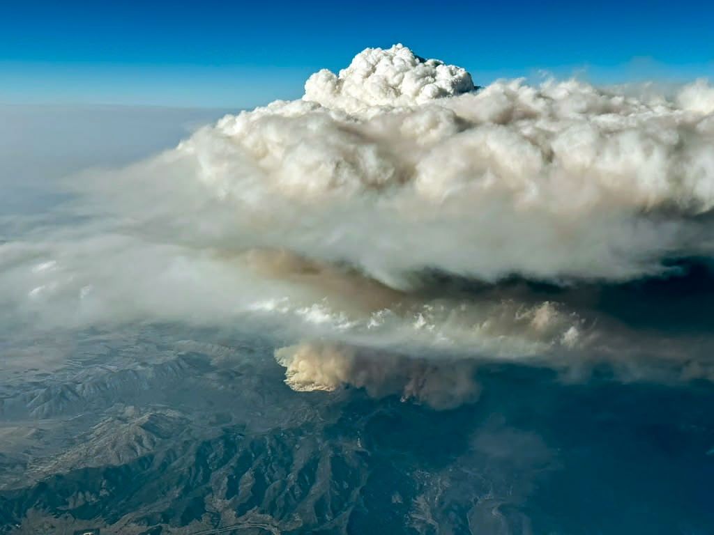
The first project to take wing this summer is Injected Smoke and PYRocumulonimbus Experiment (INSPYRE), led by the Naval Research Laboratory. From mission headquarters in Colorado, the team will chase one of the least understood forms of severe weather on Earth: towering “fire clouds” generated when extreme wildfires burn hot enough to brew their own thunderstorms.  

Pyrocumulonimbus clouds crackle with lighting in imagery captured over Utah and Colorado by the GOES-18 satellite in early July 2026.
CSU/CIRA & NOAA

Smoky and crackling with lightning, these unique storms can create blind spots for aviators above and spark new blazes below. Measuring and mapping the dangerous storms as they develop in real-time will help scientists forecast them in the future. Several aircraft, including NASA’s high-altitude ER-2, flying out of Montana, will carry a large suite of instruments over wildfire-generated storm systems. Among them will be two state-of-the-art infrared wildfire trackers, which were developed at NASA’s Jet Propulsion Laboratory (JPL) in Southern California and will be flying as part of the agency’s FireSense program.  

Testing the air over farmland, megacities 

Agricultural emissions represent an important and understudied part of Earth’s land and atmosphere systems. The FarmFlux mission, which kicks off this year, will deploy more than a dozen sensors to measure ozone, methane, ammonia, particulates, and other pollutants rising from agricultural lands and animal farms stretching from the Midwest to California’s Central Valley. These emissions affect human health, global climate, and stratospheric ozone. The mission is led by NASA’s Goddard Space Flight Center in Greenbelt, Maryland, along with Colorado State University, and Boston University. 

A Boeing 777 wide-body twin-engine aircraft looms on a taxiway, viewed directly from the front.
NASA’s 777 aircraft is gearing up to start science flights. Structural modifications – like enlarged cabin windows and instrument portals – have transformed the former passenger plane into a flying laboratory. It’s seen here at Langley Research Center in Hampton, Virginia, in April 2026.
NASA/Ryan Hill

Two North American cities with air quality concerns are Atlanta and Mexico City. But the causes differ, with weather and terrain playing a role. To explore these differences, the Hemispheric Airborne Measurements of Air Quality (HAMAQ) mission will investigate areas of poor air in the two capitals and test how satellite information can help forecasting and mitigation efforts. The team will deploy two aircraft at different altitudes: NASA’s P-3B will fly close to the surface, directly measuring fine particle and gaseous pollutants, while the recently acquired 777 science jet will soar high above, mapping pollution with remote sensors.  NASA’s Langley Research Center in Hampton, Virginia, is leading the mission. 

Fast-changing north 

As the Arctic warms at least twice as fast as the rest of Earth, data collected today can help guide communities on the front lines of change.  

Amid a rugged landscape, a snow-white glacier spills into dark blue water.
Alaska’s glaciers are losing ice and contributing to sea level rise. NASA is tracking the changes from land, air, and space.
NASA

The Snow4Flow campaign, led by the University of Arizona, seeks to measure and model how far and fast glaciers are retreating in the far north. Traversing remote icescapes across Alaska, the Yukon, Arctic Canada, Greenland, and Svalbard, Norway, they’ll sound both the near-surface and frozen depths of hundreds of glaciers while flying over in a modernized WWII-era aircraft outfitted with a scanning laser altimeter and two custom radars. Their observations, combined with satellite data and advanced models of snowfall and glacier flow, will advance our understanding of how glaciers behave in different regions of the Arctic. The mission seeks to uncover not just what these glaciers look like beneath the surface today, but the processes that will drive changes in the future. 

As permafrost thaws, rivers on the doorstep of the Arctic become conveyor belts of carbon and sediment. NASA Goddard, and the City College of New York lead a multidisciplinary team studying how rivers, lagoons, and estuaries across Alaska’s North Slope interact with the Arctic Ocean. The project, called Frontlines of Rapidly Transforming Ecosystems (FORTE) will combine optical and radar measurements from satellites, planes, high-tech research vessels, drones, and underwater autonomous systems to track microscopic marine life, water flow, and chemistry. The team will collaborate with local and tribal communities to sustain observations over time and apply NASA assets to address emerging local needs and decision-making priorities.  

Landslide triggers 

When a slow-moving landslide in California suddenly collapsed and buried a section of coastal highway in 2017, scientists at NASA JPL wanted to know how precipitation swings played a role. JPL studies how water infiltrates and destabilizes hillslopes all over the world. The Landslide Change Characterization Experiment (LACCE) project will combine airborne synthetic aperture radar with land-based sensors to track how slopes in California are responding to a world of intensifying droughts and downpours. The project also takes aim at emerging landslide hazards in Alaska, where rapidly retreating glaciers are accelerating slope movements that have the potential to create mega-tsunamis.  

This series of images shows the collapse of the Mud Creek landslide in May 2017 along the Big Sur coast in Central California, and the subsequent repairs to Highway 1, which was damaged during the event.
Andy Ritchie/USGS Pacific Coastal and Marine Science Center

NASA’s Earth Venture Suborbital program, designed to be nimble and high impact, was established following a recommendation by the National Research Council in 2007. In the decades since, teams have studied phenomena, including blizzards, coral reefs, and ocean whirlpools.  

About the Author

Sally Younger

Share

Details

Last Updated
Jul 21, 2026

NASA’s Hubble Captures Crimson Cloud Sparkling with White, Blue Stars

3 min read

NASA’s Hubble Captures Crimson Cloud Sparkling with White, Blue Stars

A Hubble image of blue and white stars are sprinkled throughout a landscape of red clouds of gas and dark, swirling lanes of dust. Many additional stars are visible in the dark background of space.
A glowing landscape of gas and dust is heated and illuminated by a thriving population of young stars in the LH 95 region of the Large Magellanic Cloud.
NASA, ESA, and N. Da Rio (The University of Virginia), G. De Marchi (European Space Agency – ESTEC), and D. Gouliermis (Universitat Heidelberg); Processing: Gladys Kober (NASA/Catholic University of America)

Like fresh fireworks launched against a background of dissipating smoke, blue and white stars shine brilliantly against a crimson background of glowing gas in this image of stellar nursery LH 95 from NASA’s Hubble Space Telescope.

LH 95 is a region in the Large Magellanic Cloud, a dwarf galaxy that orbits the Milky Way. Low-mass infant stars live alongside massive blue giant stars in what is known as a stellar association, one of many in the Large Magellanic Cloud.

The LH 95 region’s most massive stars, possessing at least three times the mass of the Sun and visible here as the largest and brightest blue stars, expel ultraviolet radiation and stellar winds that both heat and shape the surrounding hydrogen gas. Dark filaments stand out in sharp contrast against the glowing hydrogen where denser dust lanes resist erosion.

In this image, blue indicates the shorter wavelengths that are visible light, while red depicts the longer wavelengths of visible light, as well as some near-infrared light. Colors in Hubble images are chosen based on standard image processing techniques to best represent the wavelengths of light that pass through the filters used in the observation. The gas of the nebula glows crimson due to hydrogen-alpha emissions.

Hydrogen-alpha is an excellent indicator of star formation, allowing astronomers to identify very young stars embedded in this glowing gas. Researchers found developing stars still gathering material from the disks of gas and dust around them. In fact, LH 95 is home to an extraordinary 2,500 stars that have accumulated almost all of their critical mass but have not yet “turned on” by beginning fusion reactions. These stars, called “pre-main-sequence stars,” have formed from collapsing clouds of gas and are still contracting. They will soon begin burning hydrogen in their cores to become full stars.

By studying these forming stars, researchers confirmed that the stars’ accretion rate ― the rate at which they accumulate matter ― decreased with age, as expected. However, they also learned that accretion can persist for several million years, longer than sometimes assumed. This information helps refine our understanding of how young stars keep growing and how their disks evolve.

Researchers noted that distinct generations of stars in LH 95 exist side-by-side, indicating that rather than forming stars in a single event, the region produces multiple stellar generations over an extended period.

The most massive star in LH 95 (above center, slightly left) has about 60-70 times the mass of the Sun and is about a million years younger than the rest of stars in the system, which appear to be around 4 million years old. Massive stars like these burn through their fuel quickly and die in supernova explosions.

With its rich stellar population, LH 95 is valued by astronomers for providing a way to observe forming stars at relatively close range in an environment with less obscuring dust than similar regions of the Milky Way.

As one of NASA’s flagship observatories, Hubble has produced a wealth of scientific discoveries over more than 30 years in orbit. Its observations are expanded upon and enhanced by observations with other NASA missions, including the infrared-detecting Webb Space Telescope and the upcoming Nancy Grace Roman Space Telescope, which is scheduled to launch in late summer.

Facebook logo
Instagram logo

Explore More

Media Contact:

Claire Andreoli
NASA’s Goddard Space Flight CenterGreenbelt, MD
claire.andreoli@nasa.gov

❌