It's that time of year again, when we learn which lucky scientists are among the winners of the Ig Nobel Prizes. This year, the prizes honor research on designing the perfect splash-free urinal; using mosquito proboscises to "necroprint" tiny nozzles; studying composition rates of buried cotton underwear; and the aerodynamics of a healthy nose-blow, among other highlights.
Established in 1991, the Ig Nobels are a good-natured parody of the Nobel Prizes; they honor “achievements that first make people laugh and then make them think.” The unapologetically campy awards ceremony features miniature operas, scientific demos, and "24/7 lectures," whereby experts must explain their work twice: once in 24 seconds and the second in just seven words.
Acceptance speeches are limited to 60 seconds. And as the motto implies, the research being honored might seem ridiculous at first glance, but that doesn’t mean it’s devoid of scientific merit. In the weeks following the ceremony, the winners will also give free public talks, which will be posted on the Improbable Research website.
Fashionistas of a certain age no doubt remember the late designer Stephen Sprouse, who gave Blondie's Debbie Harry her distinctive Bowery punk style. Sprouse's first collections in the mid-1980s made a major splash, melding graffiti prints, a playful '60s aesthetic, and bright Day-Glo colors that won admirers such as Andy Warhol.
Several examples of Sprouse's work are preserved in the textiles collection of the Indianapolis Museum of Art at Newfields, where conservationists are trying to learn more about the phosphorescent and fluorescent pigments the designer used in his creations in order to keep the colors from dulling over time. They described recent advances in that research at a meeting of the American Chemical Society (ACS) held this week in Chicago.
Scientists began describing minerals that glowed in the dark as phosphors in the Middle Ages. Typically, such materials take on a charge when exposed to light, storing the absorbed energy and releasing it gradually as re-emitted light. Henri Becquerel discovered radioactive decay in 1896 because of his work with phosphorescent uranium salts: He left the salts in a closed drawer with photographic plates, which fogged up even without a light source. DayGlo paints and similar materials exploit the related phenomenon of fluorescence. DayGlo pigments fluoresce in daylight by essentially converting UV light into visible light to produce brighter, more vibrant colors.
Antibodies play a central role in your body's immune defense. But they're also nearly ubiquitous in biological research, being essential for several widely used lab techniques. While some researchers need to go through the process of producing their own antibodies, antibodies to many key proteins are commercially available and can be ordered for overnight delivery.
In May, however, Reese Richardson, a post-doc at Northwestern University, discovered that some of the images used to demonstrate how these antibodies performed in lab experiments had been subject to image manipulation—the sorts of changes that would get a paper retracted if they had appeared in the academic literature. The manipulations ranged from removing background noise to copying and pasting data to fabricate results. Now, he has done a more exhaustive search and found problematic manipulations in images used to market over 17,000 commercial antibodies.
Antibodies are useful in the lab because the immune system generates them to recognize specific proteins. While those proteins typically appear on the surface of pathogens, the immune system doesn't know where a given protein it encounters comes from. So, if you inject an animal with your protein of interest, it will typically generate antibodies to recognize that.
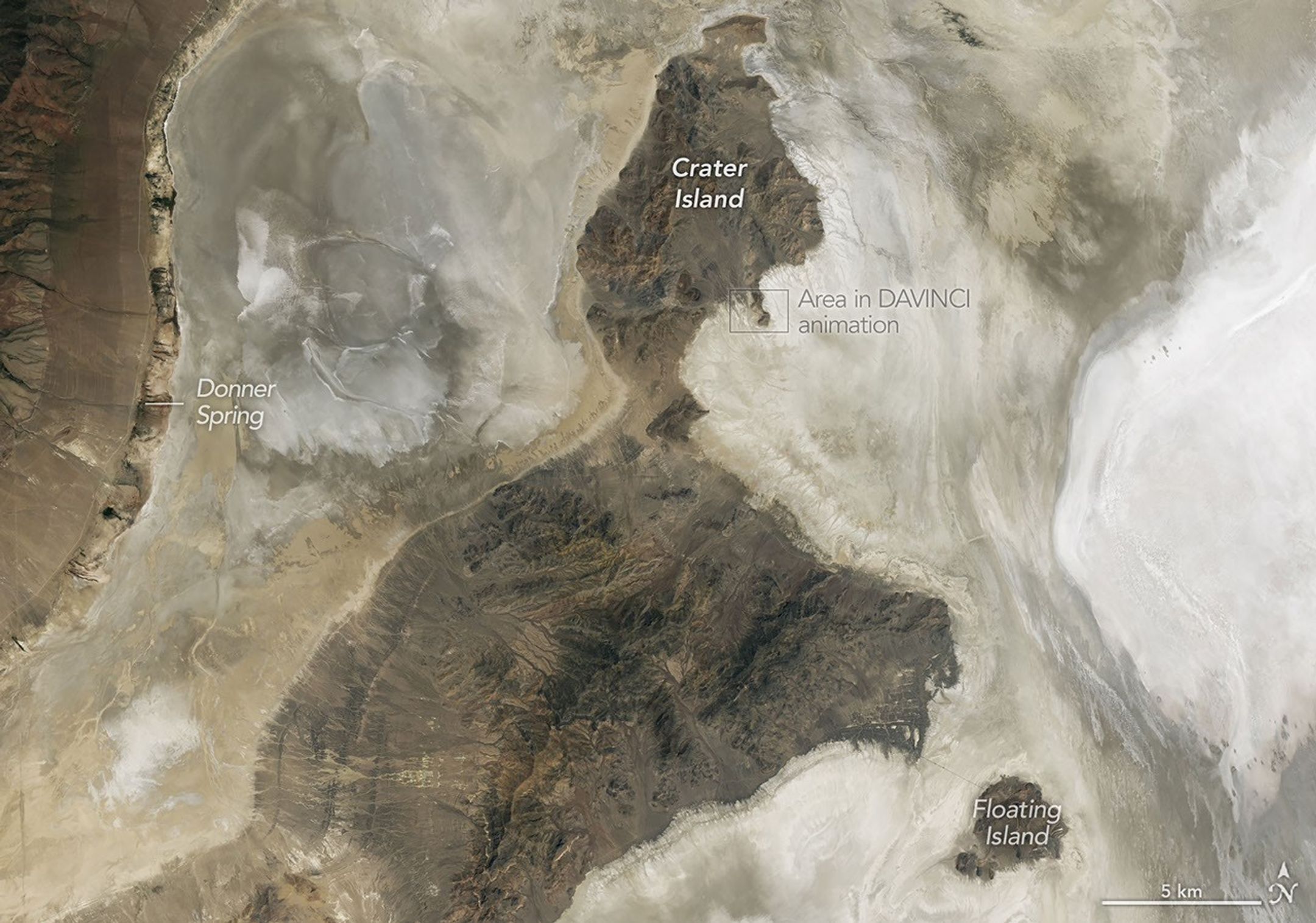
The rugged terrain of the Silver Island Mountains and Crater Island rises above the pale playa and bright salt flats of former Lake Bonneville. The image was acquired with the OLI (Operational Land Imager) on Landsat 8 on June 4, 2026, and overlaid on a digital elevation model.
NASA Earth Observatory/Michala Garrison
At its peak, ancient Lake Bonneville would have been a sight to behold. Nearly as large as Lake Michigan, the Ice Age lake spread across much of western Utah and parts of Nevada and Idaho. When it eventually receded, it left behind flat, bright playas and salt flats rich with minerals—a landscape that would later serve as the setting for feats of engineering and technological ingenuity, as well as epic tales of exploration and desperation.
Lake Bonneville began forming about 55,000 years ago during a cool, wet period, when volcanic eruptions in what’s now southeastern Idaho diverted the Bear River, causing water to gather in Gem Valley and other basins to the south. For tens of thousands of years, a natural dam at Red Rock Pass helped confine the lake.
Then, about 18,000 years ago, water breached that dam, unleashing a torrent that entered the Columbia River system. Over a six-week period, amid one of North America’s largest floods, lake levels plummeted by more than 350 feet (105 meters). As the climate warmed and dried in subsequent millennia, the lake shrank dramatically, leaving remnants that include today’s Great Salt Lake, Utah Lake, and Sevier Lake.
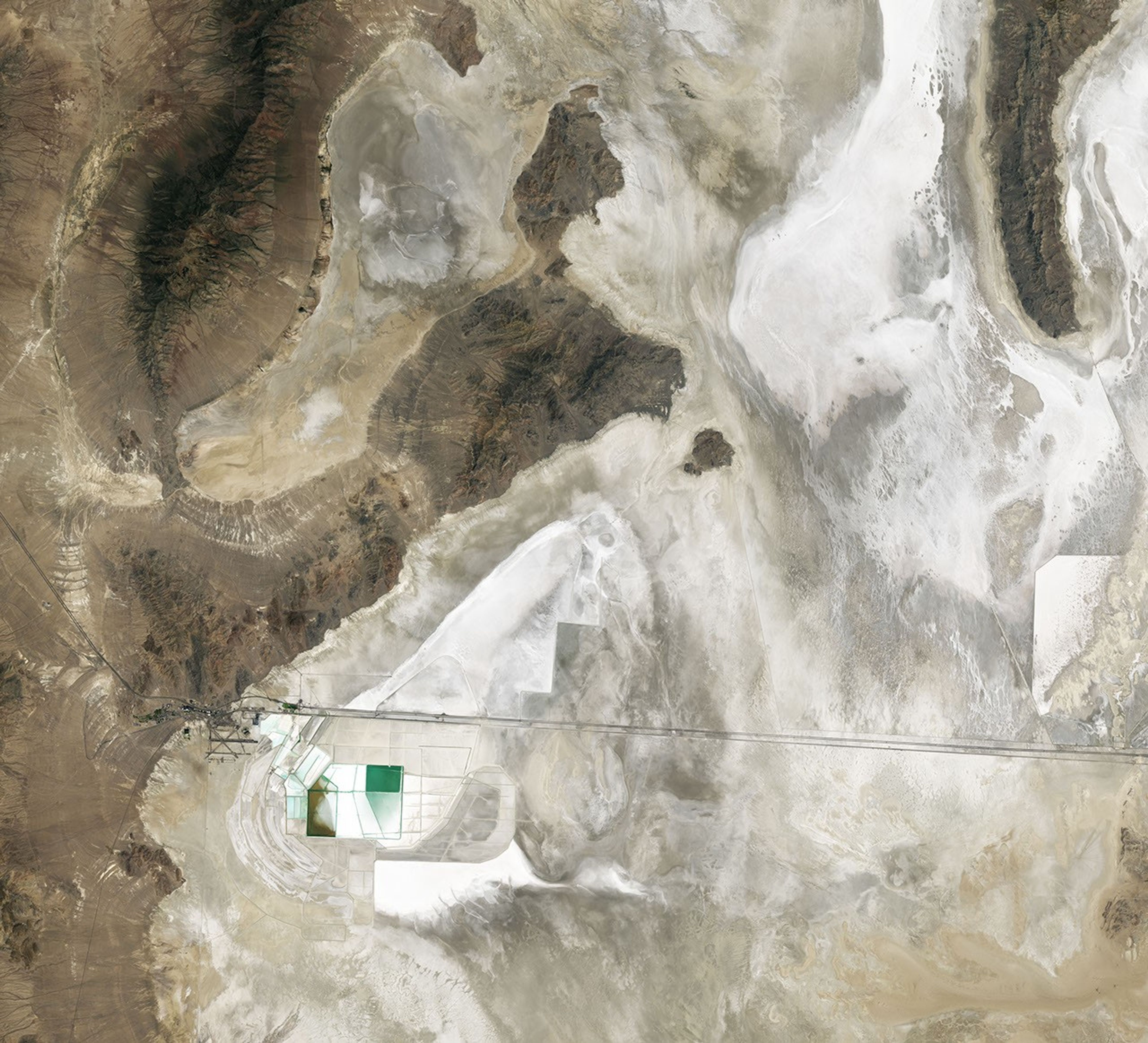
Lake Bonneville may be gone, but its imprint on the region’s landscape remains—even in satellite imagery. In this image (below) captured by the OLI (Operational Land Imager) on the NASA-USGS Landsat 8 satellite, bathtub-like rings and wave-cut terraces trace the position of former shorelines. The dried lakebed—where fine-grained clay, marl, and sandy sediment settled out of the water—appears pale in comparison to the darker, rockier, more vegetated surroundings.
NASA scientists analyzed the terrain in this part of Utah when testing technologies that will be used on NASA’s DAVINCI mission to Venus. This image was acquired with the OLI (Operational Land Imager) on Landsat 8 on June 4, 2026.
NASA Earth Observatory/Michala Garrison
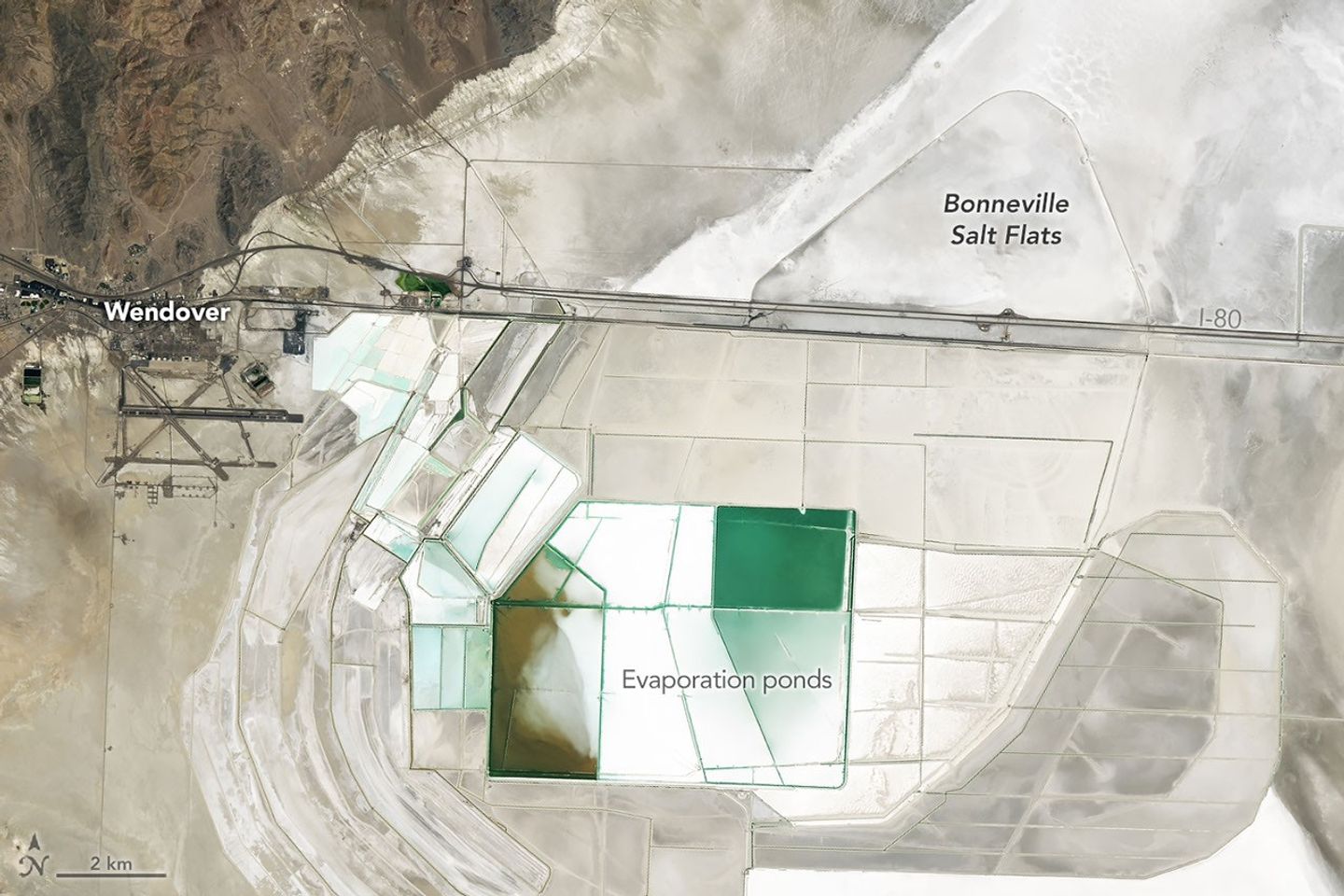
In deep parts of the basin, where runoff and groundwater still pool, bright deposits of evaporite minerals coat the land surfaces, forming salt flats. These remarkably flat surfaces are the product of water gradually evaporating and concentrating minerals to produce brines and hard mineral crusts, typically including halite and gypsum, along with potassium- and magnesium-bearing salts. Brines and deposits like these—particularly of potash, which is used as a fertilizer—have long made the playa a target for mining, as seen in the rectangular evaporation ponds above and below.
In contrast, the darker, more rugged terrain—including the Silver Island Mountains, the Newfoundland Mountains, and the Pilot Range—that rises above the playas is built from layers of erosion-resistant sedimentary and metasedimentary bedrock that is hundreds of millions of years old. These mountains also contain younger igneous and metamorphic rocks that formed when magma intruded into the ancient sedimentary sequence.
Crater Island, for instance, is composed of sedimentary rocks, including silica-rich sandstones and quartzites that formed as sands accumulated in a shallow ocean, as well as intrusions of quartz monzonite, granites, and other igneous rocks. Periods of crustal stretching later produced the fault-block mountains that define the landscape.
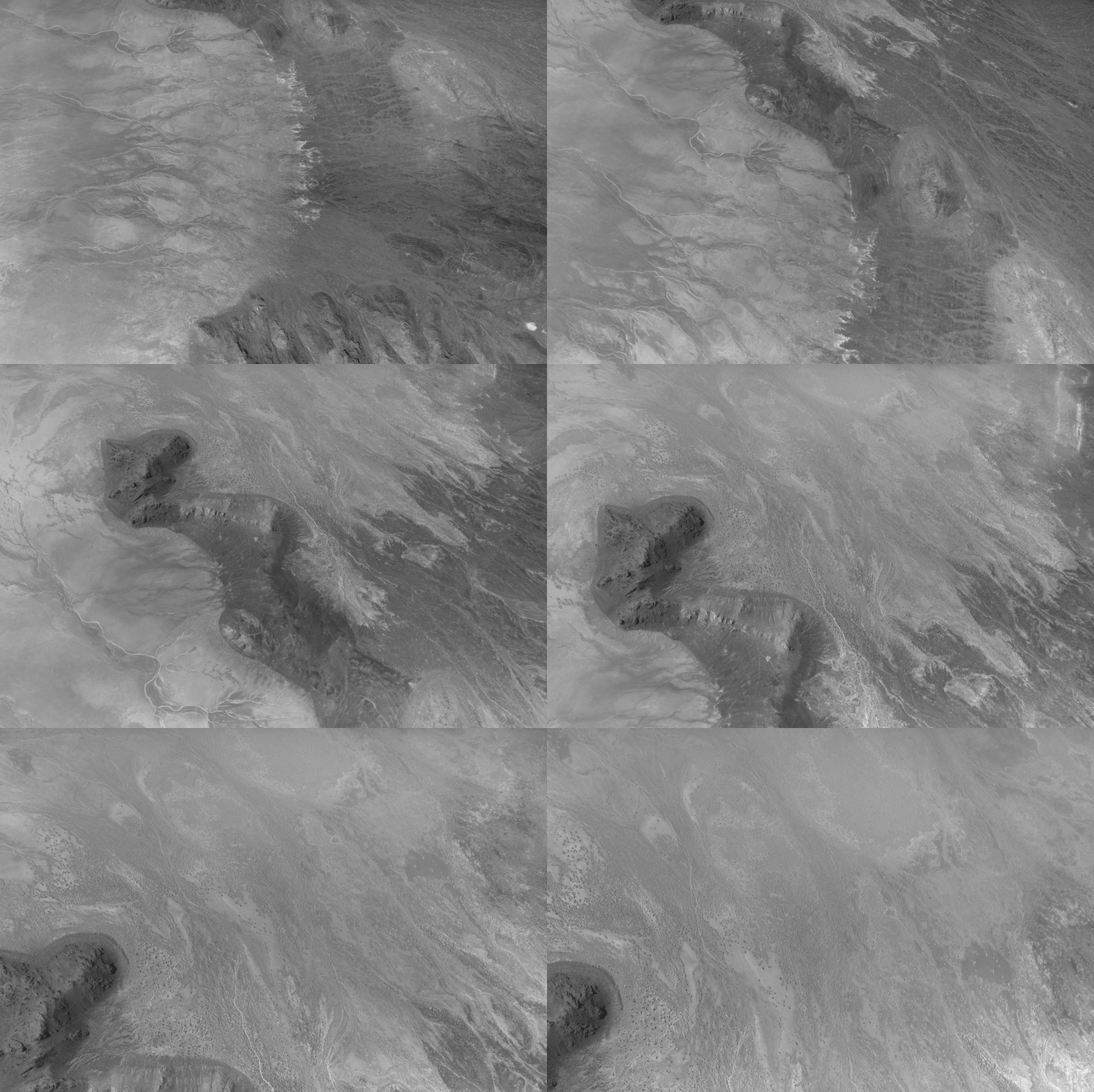
This animation shows the descent over Crater Island, Utah, of the camera system that will one day fly aboard NASA’s DAVINCI mission to Venus. It was created by stitching together 37 infrared images captured during a test on June 24, 2026.
Malin Space Science Systems/NASA/Jay Friedlander
Mapping geological distinctions like this took center stage in June 2026 when NASA scientists and engineers working with the agency’s DAVINCI mission came to Crater Island—a place they call “Venus on Earth”—to field-test the design of a set of cameras and a package of instruments that will eventually descend through the thick atmosphere of Venus and photograph mountains at scales finer than these Landsat images. During a 60-minute descent, the pioneering probe will capture near-infrared images, measure the atmospheric chemistry, and explore the environment of a world in unprecedented detail.
During the rehearsals at Crater Island, the camera system took hundreds of images of various rock formations, including iron-rich and silica-rich rock units, while suspended from a helicopter as it descended toward the surface. Using only the images acquired by DAVINCI’s camera systems, the team made three-dimensional maps of the area consistent with existing geologic maps, giving the scientists confidence that they will be able to map the geology of an analogous mountainous region on Venus that DAVINCI will study, an area called Alpha Regio.
Other epic adventures have played out on and around Lake Bonneville’s playas, as well. The flat, smooth surfaces have often been the setting for new land speed records. In 1960, Mickey Thompson became the first American to break the 400-miles-per-hour (640 kilometers-per-hour) barrier, hitting 406.60 miles per hour (654.36 kilometers per hour) in a streamlined race car on the Bonneville Salt Flats. The feat temporarily earned him the nickname “fastest man on Earth.”
People mine minerals from the Bonneville Salt Flats and use its flat surface to pursue land speed records. This image was acquired with the OLI (Operational Land Imager) on Landsat 8 on June 4, 2026.
NASA Earth Observatory/Michala Garrison
More recently, in August 2026, Andy Green, the first person to break the sound barrier on land, set a record for the fastest land speed in a hydrogen-fueled internal-combustion vehicle, reaching 406.320 miles per hour (653.909 kilometers per hour). By burning hydrogen rather than gasoline, the “rocket car” produced no carbon dioxide.
Nearly two centuries earlier, in August 1846, members of the ill-fated Donner-Reed Party also passed along the southern edge of Crater Island. As part of a shortcut toward Pilot Peak, they journeyed from Hastings Pass, past Floating Island, and toward Donner Spring. However, in an ominous sign of challenges to come, their heavy wagons broke through the thin salt crust and became mired in underlying mud, slowing them down and prompting them to abandon several wagons in the desert.
NASA Earth Observatory images by Michala Garrison, using Landsat data from the U.S. Geological Survey.Story by Adam Voiland.

 Login
Login