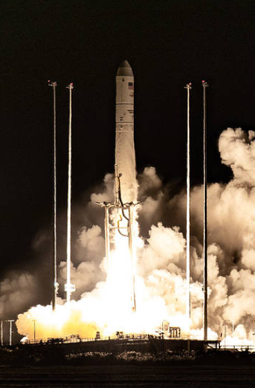
A NASA Launch Services (NLS) II contract has been awarded by the agency to Relativity Space Inc., and its Terran R launch service in accordance with the contract’s on-ramp provision. The Terran R launch service will be available to NASA’s launch services to use for future missions.
The NLS II contracts are multiple-award, indefinite-delivery/indefinite-quantity contracts with an ordering period through June 2030 and an overall period of performance through December 2032. The NLS II contracts include an on-ramp provision that provides an opportunity annually for new launch service providers to compete for future missions and allows existing contractors to introduce launch vehicles not currently on their NLS II contracts.
The NLS II contracts support the goals and objectives of the agency’s Human Spaceflight Mission Directorate, Science Mission Directorate, and the Research and Technology Mission Directorate. Under the contract, NASA also can provide launch services to other government agencies, such as the National Oceanic and Atmospheric Administration.
NASA’s Launch Services Program Office at the agency’s Kennedy Space Center in Florida manages the NLS II contracts. For more information about NASA, visit:
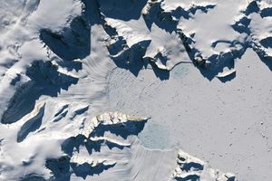
Landsat has observed evidence of emperor penguins living on Smyley Island in Antarctica as early as 1989. The TM (Thematic Mapper) on Landsat 4 captured this false-color image (left) of guano stains on fast ice on December 24, 1989. The OLI (Operational Land Imager) on Landsat 8 captured a similar scene on December 10, 2025 (right). The images combine observations of infrared, red, and green light to make it easier to distinguish the guano stains. NASA Earth Observatory images by Michala Garrison.
With their charming waddles, heat-conserving huddles, and tuxedo-like plumage, emperor penguins are among the world’s most recognizable animals. Recent satellite surveys estimate that hundreds of thousands of the flightless birds live in 66 colonies spread around Antarctica’s inaccessible, frozen coastlines. But those numbers could fall in the coming decades because emperor penguins rely on landfast (or fast) ice—a type of sea ice attached to the shoreline—to breed, raise chicks, and molt.
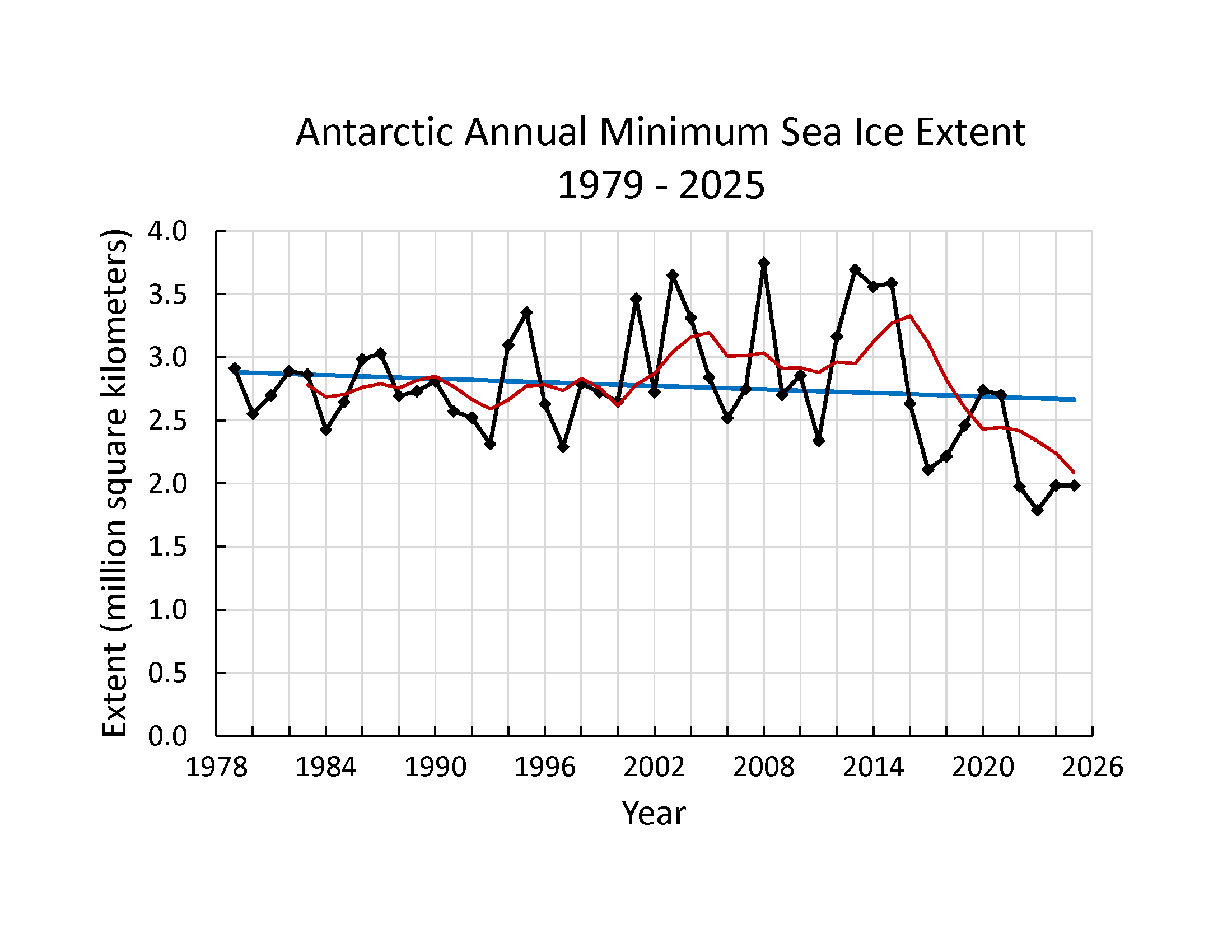
While Antarctic sea ice remained relatively stable between the late 1970s and 2015, it has been declining since 2016, and climate projections suggest that trend will continue. How landfast ice is faring remains poorly understood and is an active area of study. However, one study suggests that it has declined in West Antarctica and the Weddell Sea in recent decades even as it has trended upward in the Bellingshausen Sea and East Antarctica.
Meanwhile, some models project that emperor penguins could disappear by 2100 due to their habitats becoming inhospitable. The U.S. Fish & Wildlife Service listed emperor penguins as threatened in 2022, and the International Union for Conservation of Nature classified them as endangered in 2026.
After Antarctic sea ice cover hit a record low in 2022, British Antarctic Survey researchers reported “catastrophic” breeding failures among Bellingshausen Sea colonies. However, new research, based on decades of observations from NASA-USGS Landsat satellites, offers some hope, underscoring that many colonies have persisted for decades and that emperor penguins may be more flexible about where they breed than previously thought.
Except for a few well-studied colonies, scientists have known little about how long many emperor penguin colonies have existed, how their populations have changed, or how they have responded to past disruptions in landfast sea ice.
Adult and juvenile emperor penguins congregate on sea ice in Antarctica.
Michael Van Woert, NOAA NESDIS, ORA
“There’s little baseline information for what’s ‘normal’ for most of these colonies,” said Michelle LaRue, a wildlife ecologist at the University of Canterbury. That’s made projecting future population levels a challenge.
Two new studies published in 2026 used decades of Landsat observations to start filling gaps in understanding. Landsat cannot resolve individual penguins, but researchers identify colonies from the guano stains that accumulate where thousands of birds congregate on the ice.
Using this technique, researchers at the University of Freiburg found that 18 colonies predate their initial identification by an average of 17 years. Because Landsat has imaged Antarctica continuously since the early 1980s, it provides one of the few systematic long-term records of remote penguin colonies.
Among the oldest colonies studied was the roughly 6,000-bird Smyley Island colony in the Bellingshausen Sea, which dates to at least 1989, two decades earlier than previously known. Other colonies that predated their earliest known presence by 20 or more years included those at Barrier Bay, Brownson, Luitpold Coast, Ragnhild, Smith, and Verdi Inlet.
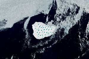
Scientists have watched the Smyley Island colony closely in recent years because it is among the colonies that may have suffered a total breeding failure in 2022. Satellite images captured that year show the colony splitting up, with some penguins moving onto a large iceberg grounded near the coast.
Despite persistently low sea-ice conditions since then, the colony has continued to appear in satellite imagery, generally establishing itself near icebergs along the edge of the ice shelf. The image above on the right shows the colony in December 2025, the most recent month Landsat has observed the colony.
“We’re seeing a degree of resilience in the Smyley Island colony,” LaRue said. “They seem to be doing okay now, and we will continue to monitor them to learn more about their behaviors.” The colony’s persistence underscores that one bad breeding year—even a total failure—doesn’t mean the end of a colony. Blizzards and predators can lead to bad years with very low chick survival rates as well, she added. “It’s when we start to see frequent breeding failures year after year that the birds won’t be able to keep up, and it starts to be a problem for a colony.”
Landsat 8 captured an image of the SANAE colony with a guano trail leading from rift ice to the ice shelf on January 23, 2018 (left). On January 4, 2023, the birds had returned to their original fast ice area (right). The images combine observations of infrared, red, and green light to make it easier to distinguish the guano stains.
NASA Earth Observatory/Michala Garrison
A second study, led by Grant Macdonald, a remote sensing scientist at Durham University, found further evidence of behavioral flexibility. Macdonald and colleagues analyzed nearly 40 years of observations from Landsat, the ASTER (Advanced Spaceborne Thermal Emission and Reflection Radiometer) on NASA’s Terra satellite, and other sources for three colonies disrupted by iceberg calving or early sea ice breakup. They found that penguins of the Mertz and SANAE colonies responded by temporarily shifting to nearby icebergs, embayments, or ice shelves before returning to their former breeding sites.
Landsat first imaged the SANAE colony in 1984 on fast ice in a sheltered bay in the Queen Maud Land region in East Antarctica. After a major calving event in 2011 exposed the fast ice to more punishing winds, the colony relocated to rift ice in an embayment 11 kilometers (7 miles) to the south. The move proved temporary. Part of the group moved to another nearby site, and part of it returned to the original breeding location in 2016.
Yet in the 2016–2017 breeding season, the returnees did something unexpected. Despite the presence of stable fast ice, they trekked onto the ice shelf and huddled and bred there. In the Landsat image above, a winding guano-stained trail traces the penguins’ route onto the ice shelf. By 2022, after roughly a decade of wandering and splitting between sites, the entire colony had returned to its original breeding ground on the fast ice, where it has bred each year since.
At the third colony the researchers studied, the Astrid colony on the Vigridisen Ice Shelf, the birds kept returning to their original breeding location even after a major calving event in 2006. That’s likely because some fast ice remained and nearby icebergs provided some shelter. The guano stains indicate that the colony did, however, sometimes spend time on a nearby ice shelf toward the end of the breeding season both before and after the calving event.
Indeed, moving and sometimes breeding on alternative surfaces such as ice shelves, icebergs, or rift ice may be “more common and feasible than previously thought,” Macdonald said, perhaps because some sites offer better shelter from wind. This willingness to move may represent a “useful adaptation” as ocean temperatures warm and sea ice declines, he added, though he cautioned that behavioral flexibility alone won’t necessarily offset the long-term effects of continued sea-ice loss.
“We have so much more to learn about emperor penguins,” added LaRue. “These colonies are so remote and difficult to access that satellites—especially government satellites with easily accessible data—are going to be absolutely invaluable to understanding what the future will bring for them.”
NASA Earth Observatory images by Michala Garrison, using Landsat data from the U.S. Geological Survey. Photo by Michael Van Woert (NOAA NESDIS, ORA).Story by Adam Voiland.
NASA’s LRO Images Falcon 9 Crater on Moon, Learns New Details
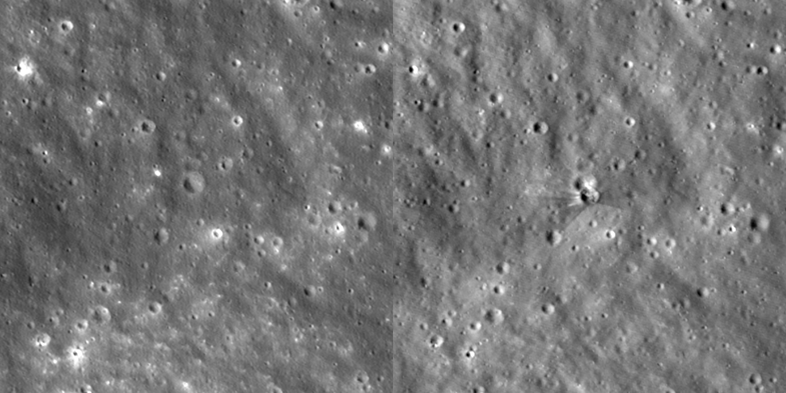
This is an animated before-and-after view of the crater formed after a Falcon 9 upper stage struck the Moon’s surface on Aug. 5, 2026. These images were taken between Aug. 11 and 12 by the Narrow-Angle Camera on NASA’s Lunar Reconnaissance Orbiter. These images are enlarged three times from the original, with north facing up, and they cover an area about a quarter of a mile wide.
NASA Goddard/Intuitive Machines
Between Aug. 11 and 12, NASA’s Lunar Reconnaissance Orbiter (LRO) captured a series of images of a new crater on the Moon. The crater formed on Aug. 5, when a SpaceX Falcon 9 upper stage impacted the surface following its January 2025 launch of the Firefly Blue Ghost 1 mission.
To capture imagery of the impact, engineers tilted the spacecraft so its cameras would point toward the crater each time LRO passed about 60 miles above the Moon, traveling 1 mile per second. The orbiter circles the Moon from pole to pole every two hours, while the Moon slowly rotates underneath it. To photograph a specific spot, the spacecraft must wait until that location turns into view, which took six days in this case.
Getting the pointing right was only half the challenge; timing had to be accurate as well. If the camera snapped even 10 seconds too early or too late, the target would drift off-center by 10 miles.
An artist concept video showing NASA’s Lunar Reconnaissance Orbiter circling the Moon.
NASA’s Goddard Space Flight Center Conceptual Image Lab
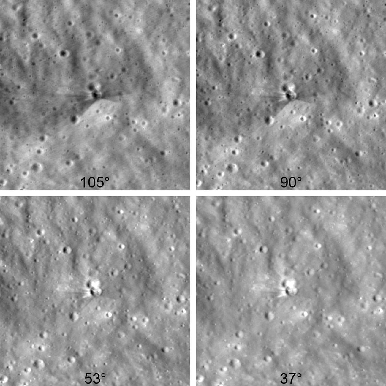
Because of the variety of viewing angles, scientists could see the crater under multiple lighting conditions that revealed unique features. In images where the crater rim stood out, scientists measured its 60‑foot width. Scientists also determined the crater is less than 10 feet deep based on the length of its shadow.
To capture these details, LRO used its Narrow-Angle Camera, which can spot features as small as 3 feet wide.
Collected between Aug. 11 and 12 by NASA’s Lunar Reconnaissance Orbiter, six days after a Falcon 9 upper-stage booster impacted the Moon, these images were taken from different viewing angles, bringing out different features. The darker area that fans around the crater in the upper-left image is rougher than the surroundings, as this surface material has been altered over a long time by solar wind, galactic cosmic rays, and micrometeorite impacts. The brighter rays and splotch above the crater in the lower-right image is fresher material that was excavated from deeper below the surface. The pictures are arranged in the order they were taken, starting at the top left and moving toward the bottom right, with the lighting angle from the Sun gradually changing from one image to the next. Each image is enlarged two times and shows an area of the Moon about 1,000 feet wide.
NASA Goddard/Intuitive Machines
The images above show bright and dark rays stretching out from the crater. The darker streaks are made of surface dust and rocks altered over a long time by solar wind, galactic cosmic rays, and micrometeorite impacts. This weathered material was excavated by the collision from 1.5 feet into the lunar surface. The brighter streaks near the crater rim are made of fresh material excavated from deeper underground.
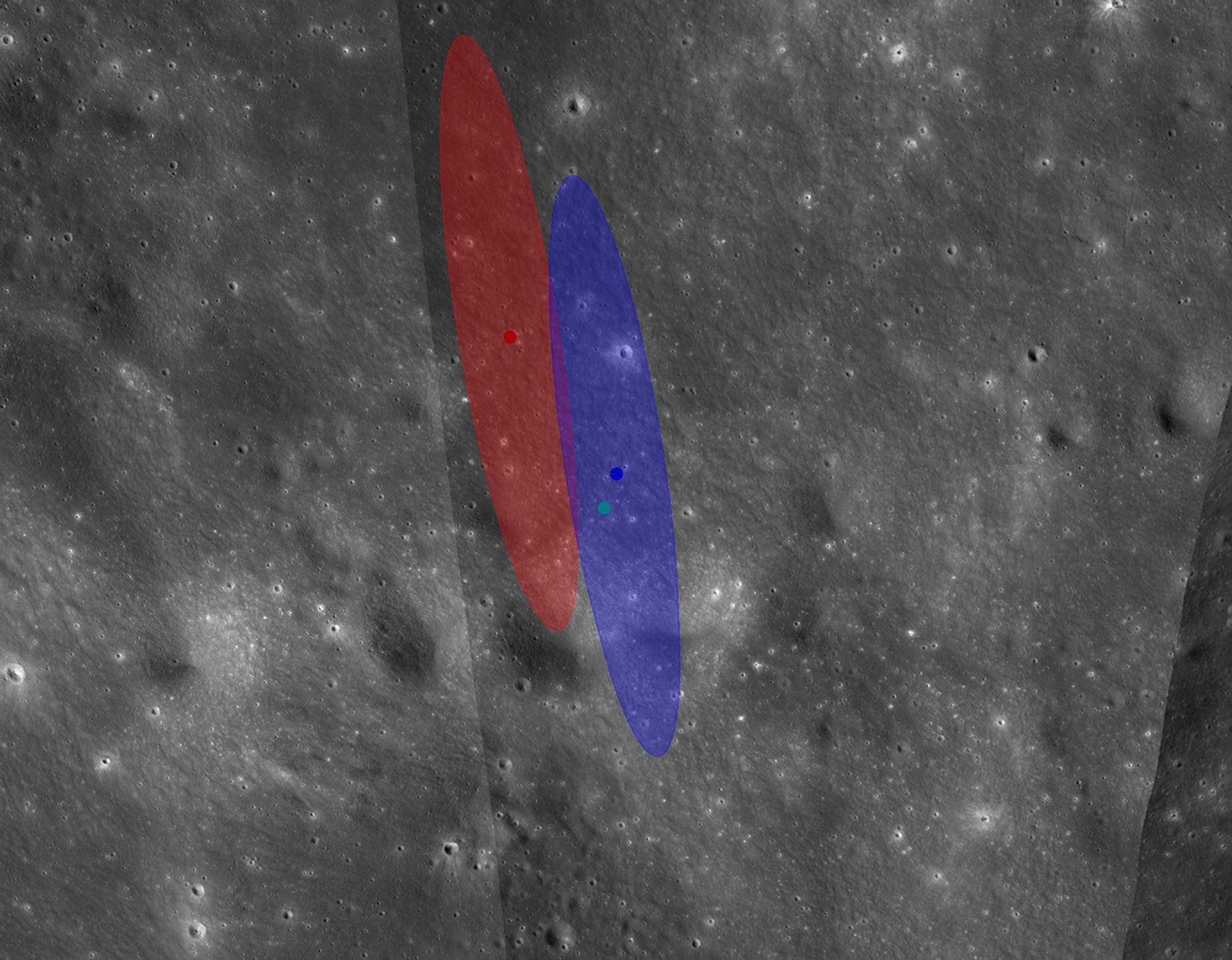
This image from NASA’s Lunar Reconnaissance Orbiter shows two oval regions where the Falcon 9 upper stage was likely to impact the Moon, based on calculations by engineers with NASA’s Center for Near Earth Object Studies. Both ellipses are 2.1 miles long and 0.4 miles wide. Both predictions use the same booster-trajectory calculations, but only the blue ellipse takes into account the lunar terrain. The red and blue dots show predicted impact locations, whereas the cyan dot shows the actual impact site.
NASA/JPL-Caltech
Finding the impact site took global coordination among experts and hobbyists. Independent astronomers first identified the rocket’s trajectory using publicly available data. NASA’s Center for Near Earth Object Studies, which tracks natural objects that could pose hazards to Earth for the agency’s Planetary Defense program, used this opportunity to test and validate tools and techniques for predicting impacts.
Based at NASA’s Jet Propulsion Laboratory in Southern California, the center incrementally refined the trajectory until identifying the location of impact, which it provided to the Republic of Korea for their Korea Pathfinder Lunar Orbiter (Danuri) team. The team used the high-resolution LUTI camera on Danuri a few hours later to image the crater, finding the prediction was accurate to about 0.6 miles.
After capturing images of the crater, the Danuri mission sent coordinates to NASA’s LRO team to help refine their follow-up imaging sequence. Comparing their new crater images with the pre-impact images, the LRO team updated the crater center coordinates: 19.4759°N, 266.7138°E, 511 meters elevation.

 Login
Login