❌

Normal view

There are new articles available, click to refresh the page.
Today — 29 October 2026Main stream

Arnab Strikes India

29 October 2026 at 00:01
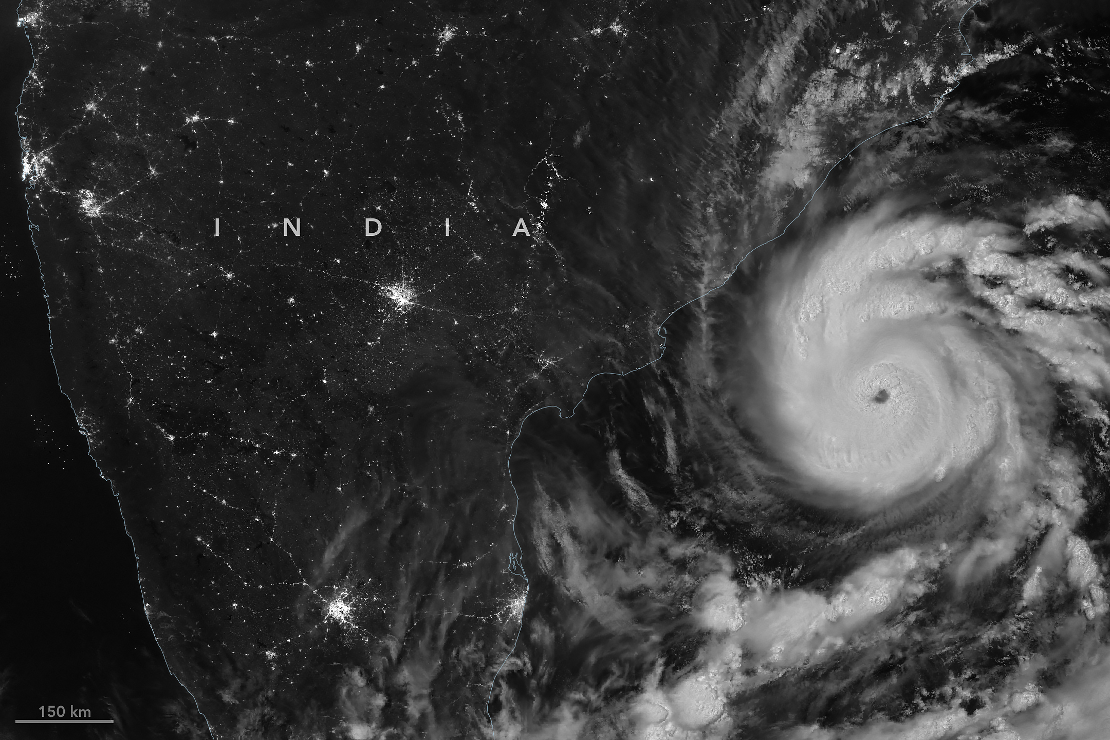
A nighttime satellite image shows Arnab's circular structure with bright white clouds as the storm approaches India's east coast. City lights are visible on darkened land surfaces on the left side of the image.

The first named storm of the 2026 North Indian Ocean cyclone season—Arnab (pronounced Or-nab)—emerged in the Bay of Bengal on October 25, a rather late start for a basin that typically produces named cyclones in April or May.

When the VIIRS (Visible Infrared Imaging Radiometer Suite) on NOAA-20 captured this nighttime image at 20:12 Universal Time on October 26 (1:42 a.m. India Standard Time on October 27), the storm had sustained winds of about 140 kilometers (85 miles) per hour, according to the India Meteorological Department (IMD).

When Arnab made landfall on the Andhra Pradesh and Yanam coast early on October 28, sustained winds were 130 kilometers per hour. IMD categorizes a storm that strength as a “very severe cyclonic storm,” which is similar to a Category 1 storm on the Saffir-Simpson hurricane wind scale. It made landfall between Bapatla and Visakhapatnam, a heavily settled area home to large cities, farmland, and fishing communities.

Arnab caused extensive damage, uprooting trees, inundating crops and homes, limiting fishing operations, and disrupting transportation and power networks, according to news reports. Prior to landfall, Indian authorities had evacuated tens of thousands of people from vulnerable coastal areas. 

The storm comes in the midst of an El Niño, a climate pattern marked by warmer-than-normal water temperatures in parts of the equatorial Pacific that emerges roughly every two to seven years. The changed ocean conditions can influence the atmosphere in ways that alter global weather patterns and change the distribution of rainfall, winds, tropical cyclones, fires, floods, and other phenomena.

In the Bay of Bengal, for instance, some research indicates that altered environmental conditions during an El Niño are associated with a reduction in tropical cyclone activity. The ocean basin sees both less frequent and less intense tropical cyclones during El Niño years, researchers have found.

NASA Earth Observatory image by Michala Garrison, using VIIRS day-night band data from NASA EOSDIS LANCE, GIBS/Worldview, and the Joint Polar Satellite System (JPSS). Story by Adam Voiland.

Downloads

A nighttime satellite image shows Arnab's circular structure with bright white clouds as the storm approaches India's east coast. City lights are visible on darkened land surfaces on the left side of the image.

October 26, 2026

JPEG (1.62 MB)

References & Resources

You may also be interested in:

Stay up-to-date with the latest content from NASA as we explore the universe and discover more about our home planet.

Explosive Intensification for Hurricane Polo

5 min read

Several ingredients came together off the Pacific coast of Mexico to generate one of the strongest storms the eastern Pacific…

Article

Lala Batters Hawaii

3 min read

The powerful storm delivered extreme rainfall and damaging winds to the state, passing the Island of Hawaiʻi as a category…

Article

Powerful Storms Continue to Prowl the Pacific

4 min read

Hurricanes Polo and Nolo sent destructive effects ashore amid an active season in the northeastern and central Pacific.

Article
Before yesterdayMain stream

Hurricane Simon Lurks Off the Mexican Coast

14 October 2026 at 00:01
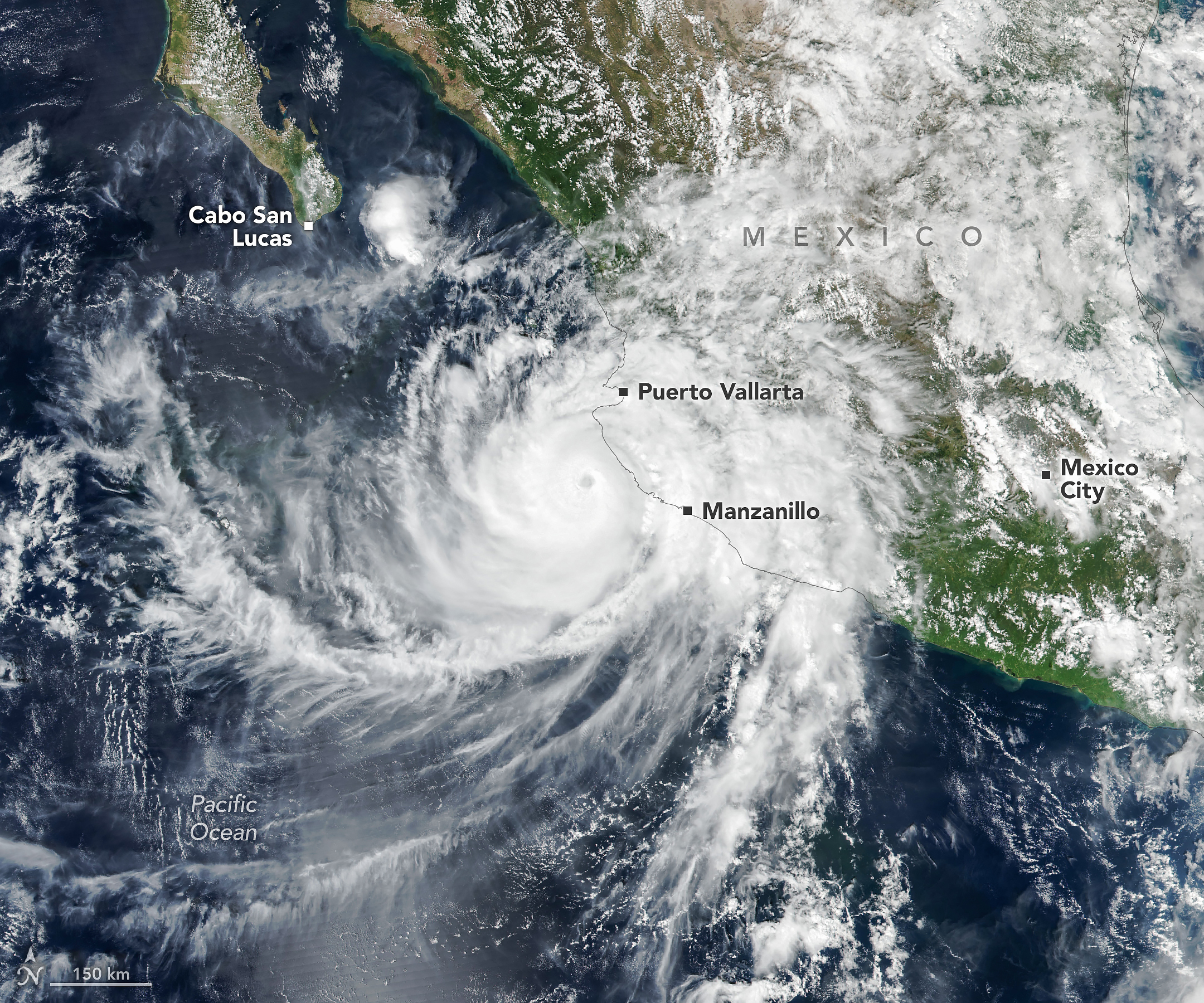
The well-defined eye of Hurricane Simon lies just off Mexico’s Pacific coast. Some outer cloud bands of the spiraling storm extend over land.
Hurricane Simon churns off Mexico’s Pacific coast in this image acquired with the VIIRS (Visible Infrared Imaging Radiometer Suite) on the Suomi NPP satellite on October 11, 2026.
NASA Earth Observatory/Michala Garrison

Hurricane Simon, the latest in a long progression of tropical cyclones in the Eastern Pacific this season, passed close to the Mexican coast as a category 4 storm on October 11, 2026. Sustained winds reached 250 kilometers (155 miles) per hour as it crept north-northwest.

Simon’s eye was about 50 kilometers (30 miles) offshore, between Manzanillo and Puerto Vallarta, when the VIIRS (Visible Infrared Imaging Radiometer Suite) on the Suomi NPP satellite acquired this image around 2:30 p.m. local time (20:30 Universal Time) on October 11.

By that time, sustained winds were about 210 kilometers (130 miles) per hour, according to the National Hurricane Center (NHC), and the storm’s inner core was brushing up against the coast. The topography of the Sierra Madre mountains appeared to temper the storm’s intensity somewhat and shrink the size of its wind field, the NHC noted. Still, the major hurricane delivered heavy rain and flooding to coastal areas, including the port city of Manzanillo, and raised the risk of mudslides in mountainous areas, according to news reports.

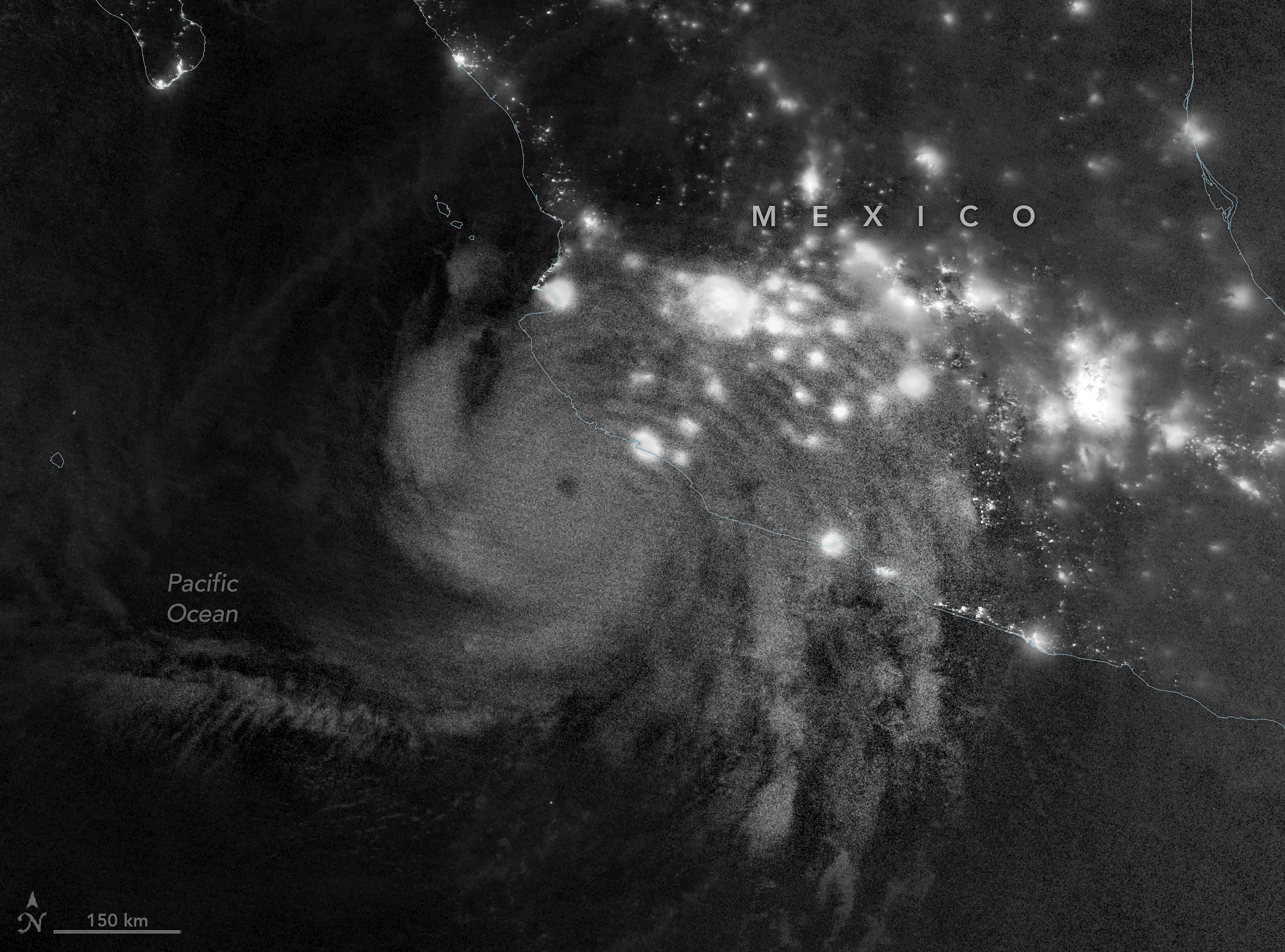
Gravity waves in the upper atmosphere appear as a semicircle of ripples in a nighttime, grayscale satellite image. Hurricane clouds and city lights in Mexico are also visible.
Atmospheric gravity waves generated by Hurricane Simon are visible via mesospheric airglow in this nighttime image acquired with the VIIRS (Visible Infrared Imaging Radiometer Suite) on the NOAA-21 satellite on October 11, 2026.
NASA Earth Observatory/Michala Garrison

In the early morning hours of October 11, satellites captured the storm’s effects extending into the upper atmosphere. This nighttime image (above), acquired with VIIRS on the NOAA-21 satellite, shows atmospheric gravity waves radiating from the hurricane. These ripples form when latent heat released near the tropical cyclone’s eyewall drives strong convection, building tall cumulonimbus clouds with updrafts that can send waves into the stratosphere and mesosphere.

But these waves are not always observable. Winds in the upper atmosphere can dissipate them before they reach the mesosphere, where they show up as ripples in airglow—faint light emitted by gases at those high altitudes. The VIIRS day-night band is sensitive to airglow but also detects reflected moonlight, which can wash it out. On the night this image was acquired, minimal illumination from the Moon helped the airglow stand out.

On the morning of October 13, forecasts of Simon’s intensity and path remained “very low confidence,” as the storm’s evolution continued to defy meteorologists’ expectations. The system may steer north and enter the Gulf of California before making landfall. Large swells causing dangerous nearshore conditions were expected along portions of the southwestern and west-central coasts of Mexico in the coming days.

NASA Earth Observatory images by Michala Garrison, using VIIRS data from NASA EOSDIS LANCE, GIBS/Worldview, the Suomi National Polar-orbiting Partnership, and the Joint Polar Satellite System (JPSS). Story by Lindsey Doermann.

Downloads

The well-defined eye of Hurricane Simon lies just off Mexico’s Pacific coast. Some outer cloud bands of the spiraling storm extend over land.

October 11, 2026: Suomi NPP

JPEG (3.05 MB)

Gravity waves in the upper atmosphere appear as a semicircle of ripples in a nighttime, grayscale satellite image. Hurricane clouds and city lights in Mexico are also visible.

October 11, 2026: NOAA-21

JPEG (1.86 MB)

References & Resources

You may also be interested in:

Stay up-to-date with the latest content from NASA as we explore the universe and discover more about our home planet.

Powerful Storms Continue to Prowl the Pacific

4 min read

Hurricanes Polo and Nolo sent destructive effects ashore amid an active season in the northeastern and central Pacific.

Article

Lala Batters Hawaii

3 min read

The powerful storm delivered extreme rainfall and damaging winds to the state, passing the Island of Hawaiʻi as a category…

Article

Tropical Storm Arthur

2 min read

The first named storm of the 2026 Atlantic hurricane season brought intense rainfall and the threat of flash flooding to…

Article

Powerful Storms Continue to Prowl the Pacific

30 September 2026 at 00:01
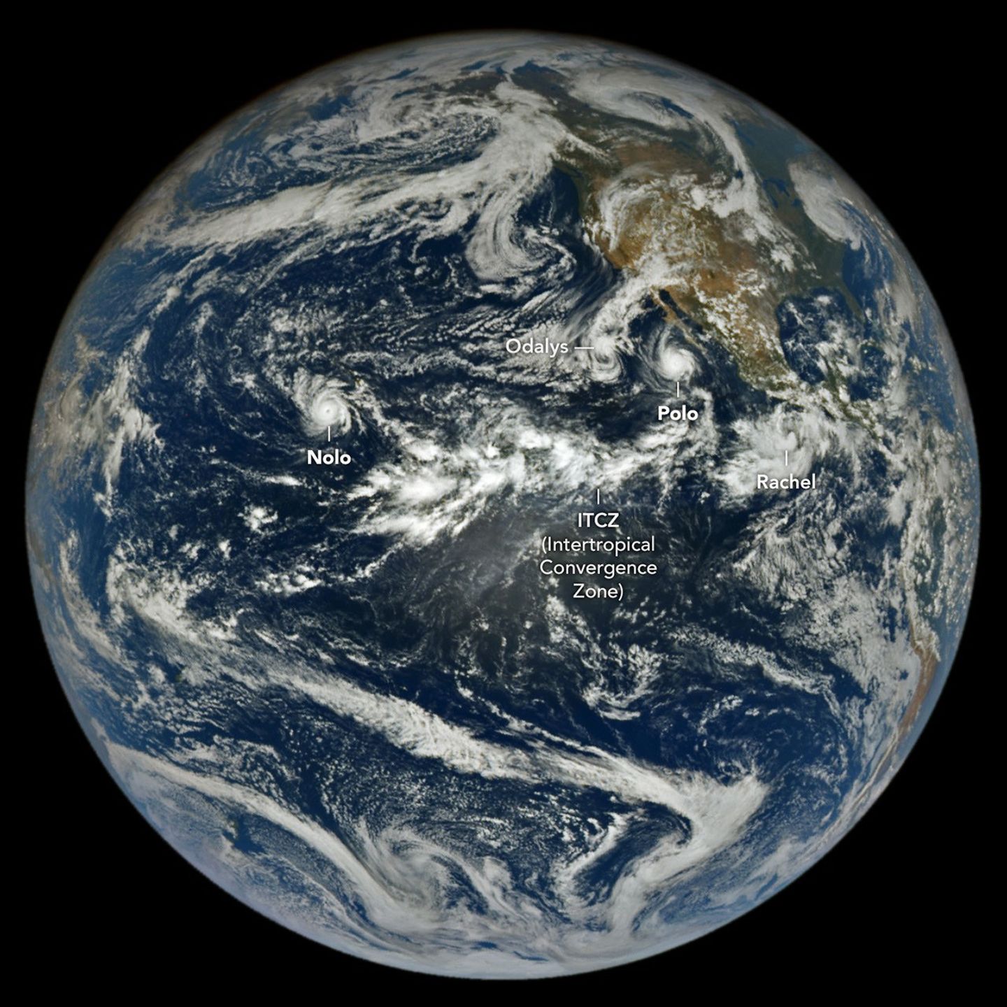
In a full-disk satellite view of Earth, several tropical cyclones swirl above the blue waters of the Pacific Ocean.
The northeastern and central Pacific basins are busy with tropical cyclone activity in this image acquired with NASA’s EPIC (Earth Polychromatic Imaging Camera) on the DSCOVR (Deep Space Climate Observatory) satellite on September 27, 2026. A band of clouds and thunderstorms associated with the Intertropical Convergence Zone (ITCZ) is visible near the center of the image.
NASA Earth Observatory/Lauren Dauphin

The 2026 tropical cyclone season in the northeastern and central Pacific basins has been busy. By September 28, the number of named storms in the region had grown to 20, of which nine had reached hurricane strength. For comparison, the 1991-2020 average by that date is 13.5 named storms with 7.4 hurricanes.

An image from NASA’s EPIC (Earth Polychromatic Imaging Camera) on the DSCOVR (Deep Space Climate Observatory) satellite, acquired on September 27, shows the basin again rife with powerful storms. Hurricane Nolo near Hawaii and Hurricane Polo off the Baja California peninsula were lashing land with high winds, storm surge, and heavy rain. On either side of Polo, Tropical Storm Rachel and Post-Tropical Cyclone Odalys were contributing to treacherous conditions along the Mexican coast and in the southwestern U.S., respectively.

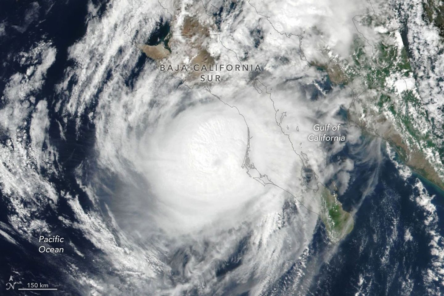
Hurricane Polo (below) made landfall in Baja California Sur around 11 p.m. local time on September 28 (06:00 Universal Time on September 29). Before encountering land, the storm had undergone extreme rapid intensification while churning over the unusually warm ocean surface, catapulting to category 5 status on September 22. Polo waned in intensity on its approach to the coast and likely made landfall as a category 2 storm, according to the National Hurricane Center (NHC).

Hurricane Polo’s clouds spiral over the Pacific Ocean and the Baja California peninsula. The storm’s faint eye is just off the west coast of the peninsula.
Hurricane Polo approaches the coast of Baja California Sur in this image acquired with the VIIRS (Visible Infrared Imaging Radiometer Suite) on the Suomi NPP satellite at 2:20 p.m. local time (21:20 Universal Time) on September 28, 2026.
NASA Earth Observatory/Lauren Dauphin

Polo then continued across the peninsula and the Gulf of California and made a second landfall, near Guaymas, as a further weakened system around midday on September 29. The NHC warned of dangerous winds and storm surge, as well as heavy rains capable of triggering flooding and mudslides in parts of Baja California Sur and Sonora.

The hurricane’s effects were expected to be even more widespread. Polo and its remnants, combined with moisture from Post-Tropical Cyclone Odalys, were likely to push over the southwestern U.S. and southern Plains over several days, forecasters said, fueling yet more heavy rain and flood risk. Next in the train of storms, Tropical Storm Rachel was tracking parallel to the southwest Mexico coast, where the NHC forecast strong winds and dangerous surf and rip current conditions.

Meanwhile, the third hurricane of the season to pass close to Hawaii was delivering yet another deluge to the islands. Hurricane Nolo, though it did not make landfall, dropped more than 12 inches (30 centimeters) of rain on parts of Maui and the Island of Hawaiʻi. The storm flooded roads, toppled trees, and triggered landslides, according to news reports, but the Island of Hawaiʻi was spared some of the more severe effects wrought by Hurricane Lala in mid-August.

As of September 28, the accumulated cyclone energy in the Northeast Pacific was more than twice the norm, according to data from Colorado State University. Scientists expect an increase in tropical cyclone activity in this ocean basin during an El Niño, which has been underway since June. Warm water in the equatorial Pacific and low wind shear in the region, both typical El Niño patterns, encourage tropical storms to develop and strengthen.

The NASA Disasters Program, in coordination with FEMA, is supporting the State of Hawaii’s response to Hurricane Nolo. The team will be posting maps and data products on its open-access mapping portal as new information becomes available.

NASA Earth Observatory images by Lauren Dauphin, using data from DSCOVR EPIC and VIIRS data from NASA EOSDIS LANCE, GIBS/Worldview, and the Suomi National Polar-orbiting Partnership. Story by Lindsey Doermann.

Downloads

In a full-disk satellite view of Earth, several tropical cyclones swirl above the blue waters of the Pacific Ocean.

September 27, 2026

JPEG (1.58 MB)

Hurricane Polo’s clouds spiral over the Pacific Ocean and the Baja California peninsula. The storm’s faint eye is just off the west coast of the peninsula.

September 28, 2026

JPEG (1.07 MB)

References & Resources

You may also be interested in:

Stay up-to-date with the latest content from NASA as we explore the universe and discover more about our home planet.

Lala Batters Hawaii

3 min read

The powerful storm delivered extreme rainfall and damaging winds to the state, passing the Island of Hawaiʻi as a category…

Article

Explosive Intensification for Hurricane Polo

5 min read

Several ingredients came together off the Pacific coast of Mexico to generate one of the strongest storms the eastern Pacific…

Article

A Trio of Tropical Cyclones in the Pacific

4 min read

The Pacific was buzzing with storms while the Atlantic was notably quiet.

Article
❌
❌